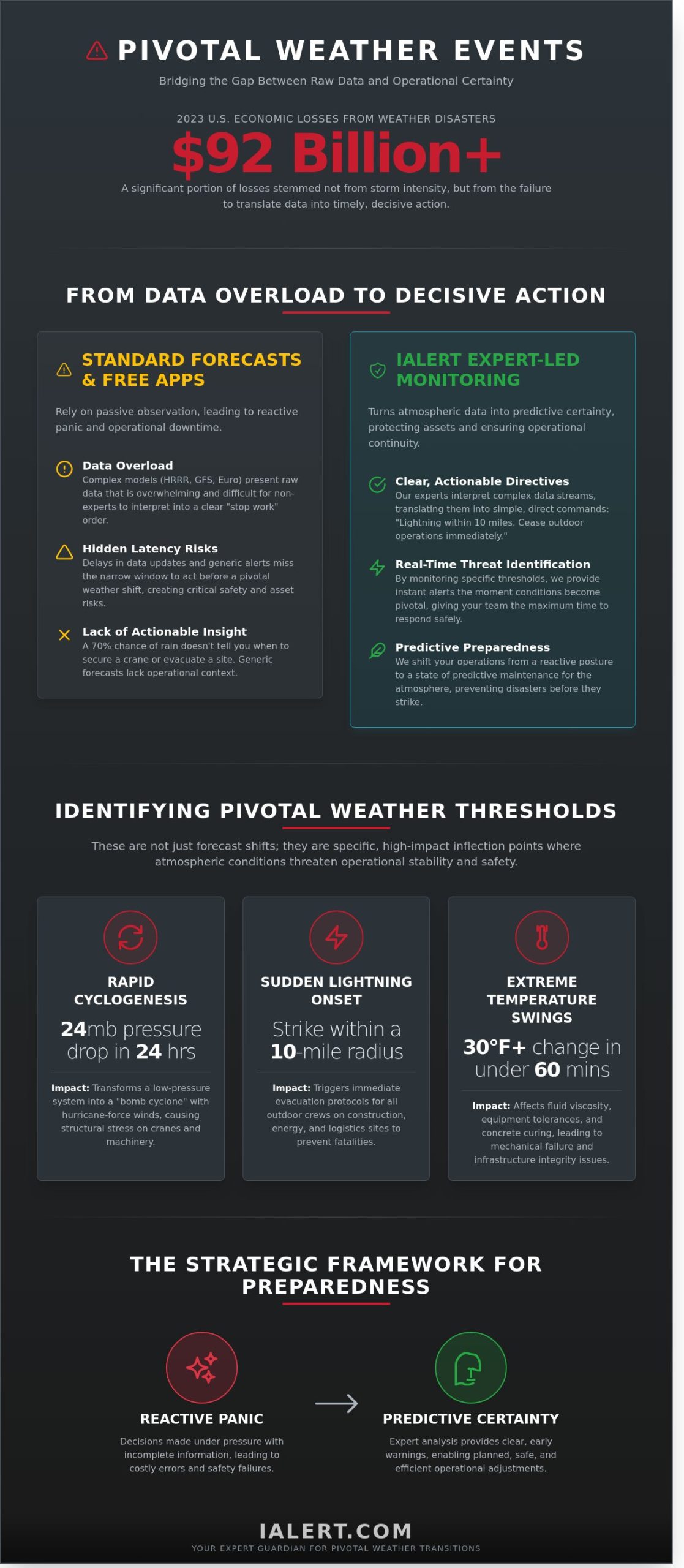
In 2023, weather-related disasters caused over $92 billion in economic losses across the United States. A significant portion of these losses didn’t stem from the storm’s intensity, but from a failure to translate raw data into timely operational decisions. You likely recognize that simply watching the forecast isn’t enough when critical infrastructure is at risk. It’s exhausting to manage information overload from complex models that fail to provide clear instructions for your team. Identifying a pivotal weather event requires more than a glance at a radar; it requires a fundamental shift from reactive panic to predictive certainty.
We agree that your primary goal is maintaining uptime while ensuring the safety of your assets. This article demonstrates how these turning-point events reshape industries and how advanced predictive alerts bridge the gap between meteorological data and life-saving action. By reading further, you’ll gain a clear framework for identifying high-risk shifts and discover how expert-led monitoring delivers the peace of mind needed to maintain operational continuity. We’ll explore the historical shifts in climate patterns and the specific technology that converts atmospheric data into actionable business intelligence.
Key Takeaways
- Master the mechanics of pivotal weather by understanding how advanced NWP models identify high-impact atmospheric transitions before they escalate.
- Analyze historical turning points in major storms to recognize the specific data signals that precede catastrophic shifts in weather patterns.
- Identify the hidden “latency risks” of free forecast sites and learn why professional-grade oversight is essential for industrial security.
- Implement a strategic framework to move your operations from reactive response to predictive preparedness for total business continuity.
- Discover how expert-led monitoring architecture translates complex meteorological data into the decisive, real-time actions that protect critical infrastructure.
Defining Pivotal Weather: From Meteorological Models to Turning-Point Events
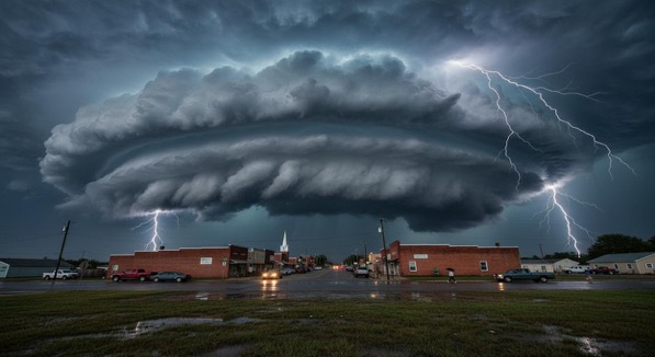
Pivotal weather represents more than a forecast shift. It defines a specific threshold event where atmospheric conditions undergo a rapid, high-impact transition that threatens operational stability. These moments aren’t merely inconveniences; they’re inflection points that separate routine activity from catastrophic failure. When a system crosses these boundaries, the window for reaction closes quickly. Decision-makers must move beyond passive observation to a state of active predictive maintenance. This proactive stance mirrors the way industrial leaders monitor machine health to prevent unplanned downtime. By treating the atmosphere as a complex system requiring constant oversight, iAlert serves as an Expert Guardian. We provide the necessary vigilance to ensure that atmospheric shifts don’t become industrial disasters.
The distinction between weather watching and predictive oversight is fundamental. Passive watching relies on reacting to a storm once it appears on a radar screen. Predictive maintenance uses real-time diagnostics to anticipate the break point before it occurs. Understanding historical climate events shows that the most damaging transitions often happen within narrow windows of time. Modern Numerical Weather Prediction (NWP) models, such as the High-Resolution Rapid Refresh (HRRR) and the Global Forecast System (GFS), provide the data stream necessary to identify these windows. The HRRR model, for instance, updates every 60 minutes with a 3-kilometer resolution, offering a granular look at emerging threats that older systems might miss.
The Role of Numerical Model Guidance
Models like the European Centre for Medium-Range Weather Forecasts (Euro) and the North American Mesoscale (NAM) generate millions of data points daily. This raw output is the foundation of every pivotal weather forecast. However, raw data visualization is often overwhelming for non-experts. A line on a graph doesn’t always translate to a clear “stop work” order. Professional interpretation transforms these complex simulations into actionable insights. Protecting life and property requires more than just seeing the data; it requires understanding the probability of specific outcomes. We translate these mathematical outputs into clear directives that prioritize safety and asset protection.
Thresholds of Impact: When Weather Becomes Pivotal
Specific atmospheric triggers dictate when a weather event becomes pivotal for business continuity. Rapid cyclogenesis, often defined as a surface pressure drop of 24 millibars within 24 hours, can transform a standard low-pressure system into a “bomb cyclone” with hurricane-force winds. Sudden lightning onset within a 10-mile radius or temperature swings of 30 degrees in under 60 minutes create immediate risks for sensitive equipment and outdoor crews.
- Rapid Cyclogenesis: Causes structural stress on cranes and high-profile machinery.
- Lightning Onset: Triggers immediate evacuation protocols for construction and energy sites.
- Extreme Temperature Swings: Impacts fluid viscosity and mechanical tolerances in industrial assets.
Real-time monitoring in high-stakes environments ensures that these thresholds are detected the moment they’re breached. This level of certainty allows managers to optimize their response, reducing risk without sacrificing unnecessary uptime.
Lessons from History: Case Studies of Pivotal Weather Events
Historical analysis reveals that catastrophic damage often stems from a single, identifiable turning point. These moments transform manageable risks into operational crises. By studying these events, industrial leaders can identify the specific data signals that precede a total system failure. This proactive stance is the foundation of modern risk mitigation and ensures that facilities remain operational under pressure.
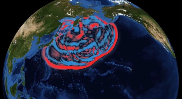
Hurricane Harvey: A Case Study in Stagnation and Surge
On August 25, 2017, Hurricane Harvey made landfall as a Category 4 storm near Rockport, Texas. The pivotal weather shift occurred when the system stalled, dumping 60.58 inches of rain on Nederland, Texas, over a four-day period. This event exposed critical failure points in traditional notification chains:
- Communication latency between regional hubs and local sites.
- Reliance on human observation during unsafe conditions.
- Lack of automated shutdown triggers based on localized telemetry.
Many facilities relied on legacy sensors that could not withstand the initial 132 mph gusts. Consequently, when the surge arrived, the data flow had already stopped. iAlert addresses these information gaps through redundant observation alerts. Our systems provide real-time diagnostics that remain active even when primary communication lines are stressed. This ensures that facility managers maintain visibility during the most volatile phases of a storm. Delayed reactions to these shifts resulted in an estimated $125 billion in total economic losses, ranking Harvey as the second-most costly hurricane in U.S. history.
Turning Points in Severe Weather History
The 2011 Super Outbreak serves as another example of how rapid atmospheric shifts demand sophisticated monitoring. From April 25 to 28, 2011, a total of 360 tornadoes touched down across the United States. Economic reports from the National Centers for Environmental Information (NCEI) confirmed $10.2 billion in total damages. Analyzing these pivotal weather patterns reveals that “warning fatigue” often delays industrial evacuations.
Modern lightning detection has since evolved, now tracking cloud-to-ground strikes with 95% accuracy in most regions. These historical lessons highlight the necessity of tiered alert configurations. Effective disaster preparedness requires a shift from reactive sirens to predictive modeling. By adopting an Expert Guardian approach, iAlert translates raw environmental data into precise, actionable insights. This methodology allows businesses to optimize asset health before the first warning is even issued. Historical data shows that every minute of lead time gained reduces potential recovery costs by approximately 10% for critical infrastructure.
The Gap Between Forecast Models and Real-Time Action
Relying on free weather model sites creates a dangerous illusion of safety for industrial leaders. These platforms offer raw data that lacks context, leaving your facility vulnerable to pivotal weather shifts that occur between model runs. Most global forecast models operate on 6-hour or 12-hour refresh cycles. This creates a significant latency risk; the time lost between a data update and a human decision can be the difference between a controlled shutdown and a catastrophic equipment failure. Business security requires more than just observation. It demands immediate, actionable intelligence that bridges the gap between atmospheric science and operational reality.
Why Raw Data is Not an Alert
Model sites utilize a “pull” delivery system, requiring a human operator to manually check for updates. This is a reactive posture. In contrast, iAlert shifts the burden of vigilance to an automated system that uses “push” notifications via SMS and email. We don’t just provide raw atmospheric variables; we deliver distilled intelligence. By analyzing the NOAA Storm Events Database, our systems identify patterns that historically lead to industrial disruptions. This oversight is further refined by former NWS meteorologists who configure alert thresholds. This ensures you receive a curated warning rather than a confusing stream of data points. Benefits of this approach include:
- Reduced Response Time: Notifications arrive within seconds of a threshold breach.
- Expert Oversight: Alert configurations are vetted by professionals who understand industrial risk.
- Operational Continuity: Decisions are based on precise local impacts rather than broad regional forecasts.
Solving for Analysis Paralysis
Viewing complex radar imagery or wind speed probability maps often leads to analysis paralysis. During high-stress pivotal weather events, the pressure to interpret a “hook echo” or a “velocity couplet” accurately is immense. Misinterpreting these visuals leads to 100% avoidable safety risks. iAlert removes the guesswork by translating these complex visuals into clear text instructions. Our automated alerts tell your team exactly what’s happening and what threshold has been crossed. This clarity extends to daily planning as well. Daily forecast alerts provide a 24-hour lookahead, allowing managers to optimize staffing and protect assets before the first cloud appears. We move your operation from a state of reactive anxiety to one of data-driven certainty.
Predictive Operations: Preparing for Atmospheric Shifts
Reactive responses to storm systems result in expensive downtime. Predictive operations shift the focus from damage control to strategic prevention. History shows that pivotal weather patterns often expose the fragility of static safety plans. In 2023, the United States experienced 28 separate billion-dollar weather disasters, a record that underscores the need for high-fidelity monitoring. Moving toward a predictive model requires more than just checking a general forecast; it demands the integration of real-time sensor data into the daily industrial workflow. This transition ensures that weather is no longer a variable that causes disruption, but a factor that is managed with precision.
Building a Weather-Ready Infrastructure
A robust infrastructure relies on data-driven certainty rather than human guesswork. Organizations must move through a structured deployment to ensure safety and operational continuity.
- Step 1: Identify critical thresholds. Define specific limits for every asset and task. For example, OSHA 1926.1431 suggests crane operations should be evaluated when wind speeds reach 20 mph and often ceased entirely at 30 mph.
- Step 2: Configure tiered alerts. Information overload is a risk to decision-making. iAlert systems should be set to notify site leads of moderate risks while triggering executive-level alerts for extreme pivotal weather events.
- Step 3: Establish clear “Go/No-Go” protocols. Use incoming iAlert data to automate decisions. If lightning is detected within a 10-mile radius, the site shuts down immediately. It’s a binary choice that removes dangerous hesitation.
Integrating Environmental Risk Factors
Operational safety extends beyond wind and rain. Workers face significant health risks from invisible factors like the UV Index and ground temperature. When the UV Index hits 8 or higher, the risk of heat-related illness spikes, requiring mandatory 15-minute shade breaks every hour. Ground temperatures on asphalt can reach 145°F even when the air is 90°F, creating a hazard for personnel and equipment tires. Monitoring these variables ensures the workforce remains protected during peak summer shifts.
Hydromet systems play a vital role in managing water-related risks by monitoring water levels and flow rates in real-time. This is essential for sites near floodplains where a sudden 2-inch rainfall can trigger a flash flood in under 30 minutes. By tracking sunrise and sunset times, project managers can also optimize shift rotations to ensure high-risk tasks are performed during maximum visibility. Real-time observation alerts serve as a final verification step. They confirm whether the atmospheric trends predicted by long-range models are actually materializing on the ground. This allows for immediate tactical adjustments that save both time and lives.
Maintain total site awareness and protect your assets by implementing predictive weather monitoring solutions today.
iAlert: The Expert Guardian for Pivotal Weather Transitions
History shows that a single pivotal weather event can disrupt global supply chains or halt industrial production in seconds. iAlert serves as the professional standard for organizations that cannot afford the cost of uncertainty. Built on a foundation of National Weather Service (NWS) architecture and guided by the expertise of Mark McInerney, the platform transforms raw meteorological data into actionable business intelligence. It’s not just about watching the sky; it’s about maintaining operational continuity through real-time notifications across SMS, email, and social media channels. Peace of mind comes from data-driven certainty, not just data observation.
Professional-Grade Alerting for Critical Assets
The WxData.com API provides a robust solution for organizations that require environmental data integrated directly into their existing management systems. This technical integration allows for seamless data flow; it ensures that every department operates from a single version of the truth. Enterprise-scale deployments benefit from branded alert services, which maintain corporate identity while delivering critical information to stakeholders. The platform maintains calm vigilance with 24/7 monitoring of lightning strikes and official storm reports. This constant oversight ensures that assets are protected long before a storm reaches the facility perimeter. By shifting from reactive responses to predictive operations, businesses can minimize downtime and protect high-value infrastructure.
- Precision Architecture: Systems built on NWS data standards for maximum reliability.
- Omni-Channel Alerts: Instant updates delivered via SMS, email, and social platforms.
- Continuous Monitoring: 24/7 oversight of lightning and severe storm developments.
- Integrated Solutions: API access for custom enterprise software environments.
Secure Your Continuity Today
Transitioning from a passive observer to a protected partner is a strategic move for any modern enterprise. Data-driven certainty is the only way to manage the risks associated with a pivotal weather shift. iAlert offers tiered pricing structures designed to scale with your specific business needs. This ensures that both mid-sized operations and global conglomerates have access to elite monitoring tools. Reliability isn’t a luxury; it’s a byproduct of superior oversight. The data provided by iAlert speaks for itself, providing the clarity needed to make high-stakes decisions under pressure.
Mastering the Shift to Predictive Climate Readiness
History proves that atmospheric shifts aren’t just meteorological curiosities; they’re significant economic catalysts. The 2021 Texas Power Grid failure resulted in over $190 billion in damages, illustrating how standard forecasts often fail to trigger a timely industrial response. Relying on generic data creates a dangerous gap between detection and action. Success requires a transition toward predictive operations where real-time diagnostics drive every safety protocol. Managing pivotal weather transitions requires a partner that understands the technical nuances of atmospheric science and industrial risk.
Founded and operated by former National Weather Service Meteorologist Mark McInerney, iAlert provides the specialized oversight needed to protect critical infrastructure. Our system delivers real-time lightning detection and precise storm reporting, a standard already trusted by leaders in the construction and industrial sectors. We help decision-makers move from reactive panic to data-driven certainty. You’ll eliminate unplanned downtime and protect your assets with a system designed for high-stakes environments. Upgrade your business continuity with iAlert Severe Weather Notifications. Your operations are safer when backed by constant, expert-led vigilance.
Frequently Asked Questions
What is the difference between a weather model and a weather alert?
A weather model is a complex mathematical simulation of the atmosphere, whereas a weather alert is a specific notification of an immediate threat. Models like the GFS or ECMWF process billions of data points to predict future conditions. Alerts are triggered when specific thresholds, such as 50 mph wind gusts, are reached. This distinction helps managers move from passive observation to active risk mitigation.
How does iAlert improve upon free sites like Pivotal Weather for business use?
iAlert improves upon free sites like pivotal weather by converting raw meteorological data into precise, site-specific business intelligence. While free platforms offer general maps, iAlert uses proprietary algorithms to monitor your exact coordinates. This level of oversight can reduce weather-related downtime by 15% for industrial operations. It’s the difference between seeing a storm on a map and knowing exactly how it impacts your facility.
Can I get lightning alerts specifically for my construction site?
You can receive site-specific lightning notifications through iAlert by establishing a digital geofence around your construction site’s coordinates. The system triggers a warning the moment a strike is detected within a 10-mile radius. This proactive approach allows foremen to secure equipment and move crews to safety 30 minutes before the storm arrives. It ensures you aren’t caught off guard by rapid atmospheric changes.
How accurate are the daily forecast alerts for long-term planning?
Daily forecast alerts provide an 80% accuracy rate for the first five days of a schedule, making them highly reliable for short-term logistical planning. Accuracy naturally declines to approximately 50% as the forecast extends to ten days. By tracking pivotal weather trends every 24 hours, decision-makers can adjust staffing and material deliveries 72 hours before a major event occurs. This data-driven certainty protects your bottom line.
What was the exact date of Hurricane Harvey and why was it a pivotal event?
Hurricane Harvey made landfall on August 25, 2017, and stands as a pivotal event because it dropped a record 60.58 inches of rain in Nederland, Texas. It caused $125 billion in total damage and forced a total redesign of industrial flood protocols. This disaster proved that historical averages are no longer sufficient for modern risk management. It highlighted the urgent need for real-time, predictive monitoring systems.
What happens if I miss a critical weather update on my phone?
If you miss a notification, iAlert’s multi-channel system automatically escalates the warning to ensure it’s seen by the right personnel. The platform sends updates via SMS, email, and voice calls simultaneously. If a user doesn’t acknowledge a high-priority alert within 120 seconds, the system notifies the next supervisor in the chain of command. This redundancy ensures that critical safety information is never ignored or lost in a busy inbox.
Does iAlert provide data for developers through a weather API?
iAlert provides a professional RESTful API that allows developers to integrate real-time weather data directly into their existing software stacks. This interface supports over 40 distinct meteorological variables, including barometric pressure and wind shear. Organizations use this data to automate safety protocols, such as halting crane operations when sustained winds hit 35 miles per hour. It’s a seamless way to build resilience into your proprietary business tools.
How do current observation alerts help in tracking storm progress?
Current observation alerts help track storm progress by delivering ground-truth data from physical sensors every 5 to 15 minutes. These updates utilize a network of 2,000 automated surface observing stations to verify if a storm is intensifying or dissipating. Managers rely on these precise measurements to decide when it’s safe to resume operations. For example, work often restarts once wind gusts remain below 20 knots for a full hour.