View All Articles

2015 U.S. Spring Flood Outlook

2015 U.S. Spring Flood Outlook Map

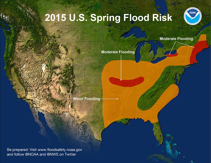
Record snowfall and unusually cold temperatures in February through early March retained a significant snowpack across eastern New England and western New York raising flood concerns. Significant river ice across northern New York and northern New England increase the risk of flooding related to ice jams and ice jam breakups. Rivers in these areas are expected to exceed moderate flood levels this spring if there is quick warm up with heavy rainfall.

There is a 50 percent chance of exceeding moderate flood levels in small streams and rivers in the lower Missouri River basin in Missouri and eastern Kansas which typically experience minor to moderate flooding during the spring. This flood potential will be driven by rain and thunderstorms.

Moderate flooding has occurred in portions of the Ohio River basin, including the Tennessee and Cumberland rivers from melting snow and recent heavy rains. This has primed soils and streams for flooding to persist in Kentucky, southern Illinois, and southwest Indiana with the typical heavy spring rains seen in this area.

Minor river flooding is possible from the Gulf Coast through the Ohio River Valley and into the Southeast from Texas eastward and up the coast to Virginia. The upper Midwest eastward to Michigan has a low risk of flooding thanks to below normal snowfall this winter. Though, heavy rainfall at any time can lead to flooding, even in areas where overall risk is considered low.

This entry was posted in Weather Articles and tagged , , , , , . Bookmark the permalink.

Leave a Reply

Read More

Mid-Atlantic severe thunderstorms wind risk map for July 4, 2026, showing SPC damaging wind probabilities up to 45 percent near Washington DC, Maryland, Virginia, and southern New Jersey

Mid-Atlantic Severe Thunderstorms Put Washington DC in Highest Wind Risk for July 4 Fireworks

Mid-Atlantic severe thunderstorms are the top weather threat on Independence Day, July 4, 2026, and Washington DC sits squarely inside the highest damaging wind risk in the country. The NOAA Storm Prediction Center has issued an…

Read More

Northern Plains severe thunderstorms wind risk map for July 2, 2026, showing a 30 percent damaging wind probability and significant severe area over the Dakotas and Minnesota

Northern Plains Severe Thunderstorms: Enhanced Risk Issued for July 2, 2026

Northern Plains severe thunderstorms are the top weather story on Thursday, July 2, 2026, as the NOAA Storm Prediction Center has placed portions of the northern Plains into the Upper Midwest under an Enhanced Risk, the…

Read More

Critical fire weather outlook from the SPC for July 1 and July 2, 2026, showing Elevated and Critical risk zones across the Southwest.

Critical Fire Weather Outlook: SPC Flags Dangerous Conditions June 30 Through July 2, 2026

Critical fire weather conditions are in place across portions of the United States from June 30 through July 2, 2026, according to a series of Day 1 and Day 2 Fire Weather Outlooks issued by the…

Read More

Leave a Reply