
View All Articles

NOAA Predicts “Above-Normal” 2025 Atlantic Hurricane Season: What You Need to Know

NOAA has released its 2025 Atlantic hurricane season outlook, predicting a 60% chance of an above-normal season, a 30% chance of a near-normal season, and only a 10% chance of below-normal activity. The season runs from June 1 through November 30. The forecast calls for 13 to 19 named storms (with winds of 39 mph or higher). Of those, 6 to 10 could become hurricanes (winds of 74 mph or higher), including 3 to 5 major hurricanes rated Category 3 or higher (winds of 111 mph or more). NOAA stated it has 70% confidence in these ranges.
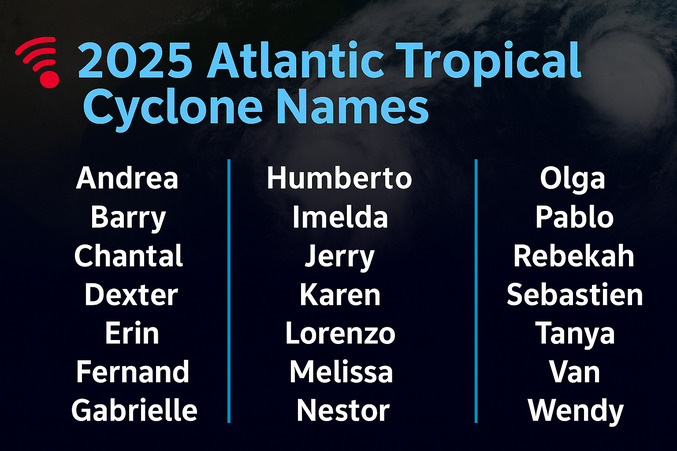
2025 Atlantic Hurricane Names: Andrea, Barry, Chantal, Dexter, Erin, Fernand, Gabrielle, Humberto, Imelda, Jerry, Karen, Lorenzo, Melissa, Nestor, Olga, Pablo, Rebekah, Sebastien, Tanya, Van, Wendy

2025 Atlantic Hurricane Names: Andrea, Barry, Chantal, Dexter, Erin, Fernand, Gabrielle, Humberto, Imelda, Jerry, Karen, Lorenzo, Melissa, Nestor, Olga, Pablo, Rebekah, Sebastien, Tanya, Van, Wendy

“NOAA and the National Weather Service are using the most advanced weather models and cutting-edge hurricane tracking systems to provide Americans with real-time storm forecasts and warnings,” said Commerce Secretary Howard Lutnick. “With these models and forecasting tools, we have never been more prepared for hurricane season.”
This season’s above-normal outlook is driven by several contributing factors, including ENSO-neutral conditions, warmer-than-average Atlantic Ocean temperatures, and forecasts for weak wind shear. NOAA also highlights the potential for increased activity from the West African Monsoon, which can produce tropical waves that often grow into long-lived storms. In addition, high ocean heat content and reduced Atlantic trade winds are expected to provide favorable fuel and atmospheric conditions for hurricane development and intensification. Acting NOAA Administrator Laura Grimm emphasized that hurricane threats extend well beyond coastal regions.
“As we witnessed last year with significant inland flooding from hurricanes Helene and Debby, the impacts of hurricanes can reach far beyond coastal communities,” said Grimm. “NOAA is critical for the delivery of early and accurate forecasts and warnings, and provides the scientific expertise needed to save lives and property.”
“In my 30 years at the National Weather Service, we’ve never had more advanced models and warning systems in place to monitor the weather,” said NOAA’s National Weather Service Director Ken Graham. “This outlook is a call to action: be prepared. Take proactive steps now to make a plan and gather supplies to ensure you’re ready before a storm threatens.”
For a deeper dive into the 2025 hurricane season forecast, listen to the WxWaves podcast episode, “2025 Hurricane Season Outlook“. The episode breaks down NOAA’s outlook, explains the science behind the predictions, and shares practical preparedness tips for individuals and communities. For the latest forecasts and storm updates, visit iAlert.com.


You May Also Find Interesting:

This entry was posted in Emergency Preparedness, News & Events and tagged , , , , . Bookmark the permalink.

Leave a Reply

Read More

Ohio Valley severe thunderstorms outlook August 1, 2026: SPC Slight Risk from Cincinnati through Kentucky to north Alabama

Ohio Valley Severe Thunderstorms: Damaging Wind and Tornado Threat From Kentucky to North Alabama, August 1, 2026

Ohio Valley severe thunderstorms are the primary concern for August 1, 2026, as the NOAA Storm Prediction Center has issued a Slight Risk outlook across parts of the Ohio and Tennessee Valleys. The risk corridor starts…

Read More

Extremely critical fire weather risk areas for Saturday, August 1, 2026. Elevated in orange, Critical in red, Extremely Critical in magenta. Source: NOAA Storm Prediction Center.

Extremely Critical Fire Weather Forecast for the Columbia Basin, August 1, 2026

Extremely critical fire weather risk areas for Saturday, August 1, 2026. Elevated in orange, Critical in red, Extremely Critical in magenta. Source: NOAA Storm Prediction Center Day 2 Fire Weather Outlook, mapped by iAlert.com. Extremely critical…

Read More

Ozarks severe thunderstorms Slight Risk area on the NOAA Storm Prediction Center Day 1 categorical outlook map for July 31, 2026

Ozarks Severe Thunderstorms: Slight Risk of Damaging Wind and Hail July 31, 2026

Ozarks severe thunderstorms are the headline hazard for July 31, 2026, as the NOAA Storm Prediction Center has issued a Slight Risk covering parts of the Ozarks and mid Mississippi Valley, with damaging wind gusts and…

Read More

Leave a Reply
