View All Articles

Drought Defined

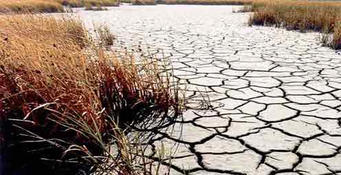
Drought ImageA drought is a period of drier-than-normal conditions that results in water-related problems. When rainfall is less than normal for several weeks, months, or years, the flow of streams and rivers declines, water levels in lakes and reservoirs fall, and the depth to water in wells increases. If dry weather persists and water-supply problems develop, the dry period can become a drought. The term “drought” can have different meanings to different people, depending on how a water deficiency affects them. Droughts have been classified into different types such as:
  • meteorological drought – lack of precipitation
  • agricultural drought – lack of soil moisture, or
  • hydrologic drought -reduced streamflow or groundwater levels
It is not unusual for a given period of water deficiency to represent a more severe drought of one type than another type. For example, a prolonged dry period during the summer may substantially lower the yield of crops due to a shortage of soil moisture in the plant root zone but have little effect on groundwater storage replenished the previous spring. Source: usgs.gov

This entry was posted in Weather Glossary and tagged , , , , , , , . Bookmark the permalink.

Leave a Reply

Read More

Southern Plains severe storms SPC Day 1 outlook for October 14, 2026, with a Slight Risk over Oklahoma and West Texas and Marginal Risk areas fromTulsa to the Mid-Atlantic

Southern Plains Severe Storms: SPC Slight Risk for Oklahoma and West Texas on October 14, 2026

Southern Plains severe storms are the main severe weather concern across the country on Wednesday, October 14, 2026, with the NOAA Storm Prediction Center placing Oklahoma City, Lawton and Ardmore in Oklahoma, along with Midland, Odessa…

Read More

Panama earthquake USGS ShakeMap showing M7.7 epicenter near Pitaloza Arriba on the Azuero Peninsula, October 9, 2026

Panama Earthquake: Magnitude 7.7 Strikes Near Pitaloza Arriba, USGS Issues RED Alert

USGS ShakeMap of the M7.7 Panama earthquake. The star marks the epicenter; red and orange contours show the strongest estimated shaking. Source: U.S. Geological Survey. A powerful Panama earthquake struck the Azuero Peninsula on Friday, October…

Read More

Hurricane Isaias landfall forecast track map showing the NHC cone from the Gulf of Mexico to the Alabama and Florida Panhandle coast with Gulf Coast warnings, October 9, 2026

Hurricane Isaias Landfall Expected Tonight on the Northern Gulf Coast as Storm Nears Major Hurricane Strength

Hurricane Isaias position at 7 AM CDT Friday, October 9, 2026, with the NHC forecast track and cone toward the northern Gulf Coast and active coastal and inland warnings. Map: iAlert.com Hurricane Isaias landfall is expected…

Read More

Leave a Reply


