The simple answer is, you’re not receiving duplicate alerts. Let me explain….
The official source of severe thunderstorm warnings and tornado warnings is the National Weather Service (NWS) and is the source used by iAlert.com. There are two scenarios which may cause iAlert users to feel duplicate warnings are received: 1) The life cycle a warning once issued and 2) warnings are issued on individual storm cells….
Life Cycle of a Severe Thunderstorm Warning and Tornado Warning Message:
- Initial Warning Issued: NWS issues severe thunderstorm or tornado warning with location, time duration, and other storm related information.
- Mid-point statement: As the storm progresses NWS forecasters update the initial warning with the latest details of the event, typically at the halfway point of the warning duration time. It is possible to have multiple midpoint statements updating storm information as the situation warrants.
- Corrections of Warning (Optional): Sometimes the NWS discovers information in the warning message that requires a correction to be sent and as corrections are issued you receive as an iAlert subscriber.
- Extension of Warning (Optional): Sometimes storms continue longer than first anticipated in the initial warning and the NWS issues an extension of the warning time. If an extension is sent by the NWS as an iAlert subscriber you will receive.
- Expired Message: Dangerous event has passed and so warning has been expired
Severe Thunderstorm Warning and Tornado Warning Message Issued on Individual Storm Cells:
- As the title suggests the NWS will issue a severe thunderstorm warning or tornado warning by storm “cell”, multiple “cells” can occur in a single storm, and near your location so you receive multiple warnings because of multiple occurrences.
- The example radar image shows 9 different thunderstorm “cells” 5 of which are severe thunderstorm warnings highlighted by the green triangle and yellow box showing direction. See the close proximity and potential for you to receive multiple warnings on different storm cells?
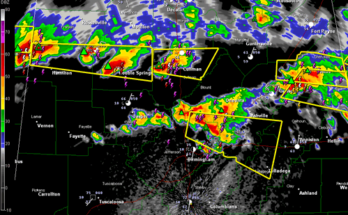
So, in a large scale outbreak it is possible to receive multiple severe thunderstorm warnings and tornado warnings at your location, in combination with multiple alert messages received for each warning as part of the storm life cycle.
Finally, consider what it is we are talking about. If you find yourself receiving multiple severe thunderstorm warnings or tornado warnings don’t get frustrated these are life threatening situations and so heed the alerts and take cover!



