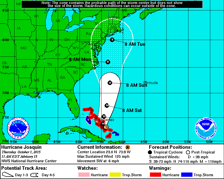
Hurricane Joaquin Track Forecast as of 11am October 1 2015 (click to enlarge)
At 1100 AM EDT (1500 UTC), the center of Hurricane Joaquin was
located near latitude 23.0 North, longitude 73.9 West. A turn
toward the northwest and north is expected on Friday, and a faster
motion toward the north is expected Friday night and Saturday. On
the forecast track, the center of Joaquin will move near or over
portions of the central Bahamas today and tonight and pass near or
over portions of the northwestern Bahamas on Friday.
Reports from an Air Force Reserve Hurricane Hunter aircraft indicate
that maximum sustained winds have increased to near 125 mph (205
km/h) with higher gusts. Joaquin is a category 3 hurricane on the
Saffir-Simpson Hurricane Wind Scale. Some additional strengthening
is possible during the next 24 hours, with some fluctuations in
intensity possible Friday night and Saturday.
Hurricane force winds extend outward up to 45 miles (75 km) from the
center and tropical storm force winds extend outward up to 140 miles
(220 km).
The latest minimum central pressure reported by the Hurricane
Hunter aircraft is 942 mb (27.82 inches).
HAZARDS AFFECTING LAND
WIND: Hurricane conditions are expected to continue in portions of
the central and southeastern Bahamas through Friday. Hurricane
conditions are expected over portions of the northwestern Bahamas on
Friday. Tropical storm conditions will affect other portions of the
southeastern Bahamas through tonight.
STORM SURGE: A very dangerous and life-threatening storm surge will
raise water levels by as much as 5 to 10 feet above normal tide
levels in the central Bahamas in areas of onshore flow. A storm
surge of 2 to 4 feet above normal tide levels is expected in the
remainder of the Bahamas within the hurricane warning area. Near
the coast, the surge will be accompanied by large and dangerous
waves.
RAINFALL: Joaquin is expected to produce total rain accumulations
of 10 to 15 inches over the central Bahamas with isolated maximum
amounts of 20 inches are possible. Rainfall amounts of 5 to 10
inches are expected over the southeastern Bahamas with 2 to 4 inches
over the northwestern Bahamas. This rainfall could result in
life-threatening flash floods. Outer rain bands of Joaquin may
affect portions of eastern Cuba, Haiti, and the Dominican Republic
today and tonight.
SURF: Swells generated by Joaquin will affect portions of the
Bahamas during the next few days, and will begin to affect portions
of the southeastern coast of the United States today and spread
northward through the weekend. These swells are likely to cause
life-threatening surf and rip current conditions. Regardless of
Joaquin’s track, a prolonged period of elevated water levels and
large waves will affect the mid-Atlantic region, causing
significant beach and dune erosion with moderate coastal flooding
likely. Please consult products from your local weather office.
Related Information: