Author Archives: iAlert.com
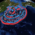
Tsunami Animation: Northern Chile, April 1 2014
Tsunami animation resulting from the April 1, 2014 earthquake off northern Chile.Source: NOAA Video is a NOAA NWS Pacific Tsunami Warning Center animation of the tsunami generated from an offshore 8.2 magnitude earthquake near northern Chile April 1, 2014
NOAA predicts moderate flood potential in Midwest, ice jams; California and Southwest remain in drought conditions
According to NOAA’s Spring Outlook released today, rivers in half of the continental United States are at minor or moderate risk of exceeding flood levels this spring with the highest threat in the southern Great Lakes region due to above-average snowpack and a … Read More…
“Turn Around Don’t Drown” Program turns 10 years old in 2014
Flooding remains one of the top weather killers in the U.S., with the average number of annual fatalities totaling near 90. More than half of these fatalities are vehicle-related. The National Weather Service has been working to bring those numbers down and, for … Read More…
How is wind chill calculated (wind chill formula)
The wind chill temperature is calculated using the following formula: Windchill (F) = 35.74 + 0.6215T – 35.75(V^0.16) + 0.4275T(V^0.16) Where: T = Air Temperature (F) V = Wind Speed (mph) ^ = raised to a power (exponential) More about wind chill: Download … Read More…
What is Hypothermia?
Hypothermia occurs when body temperature falls below 95 degrees Fahrenheit. Visible warning signs include uncontrollable shivering, memory loss, disorientation, incoherence, slurred speech, drowsiness, and exhaustion. The U.S. governments Occupational Safety & Health Administration (OSHA) recommended steps for a person suffering from hypothermia: Call … Read More…
What is frostbite?
Frostbite is freezing of the skin and underlying tissues. The lower the temperature, the quicker frostbite will occur. Frostbite typically affects the extremities, particularly the feet, toes, hands, fingers, ear lobes, or tip of the nose. The U.S. government’s Occupational Safety & Health … Read More…
Premium Membership Rate Increase Notice
Premium membership allows full access to all iAlert.com services at a locked-in rate. For the last two years this rate has remained flat at $15 per year helping cover high operating costs of this member supported service. However, as our services grow so … Read More…
Real-Time Local Weather Conditions for the U.S.
iAlert.com introduces Real-Time Local Weather Conditions for the U.S. This service offers search and display of current and historic weather conditions throughout the U.S. directly from our website. These weather observations can be accessed from the main iAlert.com web page under “Current Weather … Read More…
-

-
Thunderstorm Basics: Structure, Types, and Forecasting Methods
August 29, 2025
-

-
Saffir-Simpson Hurricane Wind Scale
June 9, 2025

