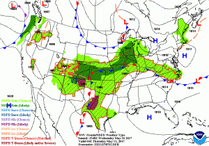
 ..Unsettled conditions from the Rockies to the Ohio Valley, and mainly
dry for the Southeast states…
The weather pattern through the middle to end of the week will evolve from
an omega block pattern, with upper level lows over the Desert Southwest
and New England, to a more progressive pattern by Friday. The upper low
is forecast to reach the central Plains by Thursday morning and become
weaker aloft while sustaining a frontal boundary across the Ohio Valley
and central Plains.
In terms of sensible weather impacts, expect scattered to numerous showers
and thunderstorms from the central Rockies eastward to the Ohio Valley and
central Appalachians, with the greatest rainfall amounts likely across
Kansas and also for parts of West Virginia. Severe weather will be
possible from Texas to Indiana over the next two days with moisture
returning northward from the Gulf of Mexico, and the Storm Prediction
Center has additional details on that. Temperatures are forecast to warm
up for the Desert Southwest and southern Rockies, which had been cooler
with the upper level low in place early in the week.
Across the eastern U.S., temperatures are also expected to be below
average through mid-week compared to early May standards. This will
especially be the case across the Northeast U.S. and the Great Lakes
region. Rain chances will increase by the end of the week as moisture
returns from the west.
..Unsettled conditions from the Rockies to the Ohio Valley, and mainly
dry for the Southeast states…
The weather pattern through the middle to end of the week will evolve from
an omega block pattern, with upper level lows over the Desert Southwest
and New England, to a more progressive pattern by Friday. The upper low
is forecast to reach the central Plains by Thursday morning and become
weaker aloft while sustaining a frontal boundary across the Ohio Valley
and central Plains.
In terms of sensible weather impacts, expect scattered to numerous showers
and thunderstorms from the central Rockies eastward to the Ohio Valley and
central Appalachians, with the greatest rainfall amounts likely across
Kansas and also for parts of West Virginia. Severe weather will be
possible from Texas to Indiana over the next two days with moisture
returning northward from the Gulf of Mexico, and the Storm Prediction
Center has additional details on that. Temperatures are forecast to warm
up for the Desert Southwest and southern Rockies, which had been cooler
with the upper level low in place early in the week.
Across the eastern U.S., temperatures are also expected to be below
average through mid-week compared to early May standards. This will
especially be the case across the Northeast U.S. and the Great Lakes
region. Rain chances will increase by the end of the week as moisture
returns from the west. Heavy Rains and the Threat of Flash Flooding across the Central U.S.
..Unsettled conditions from the Rockies to the Ohio Valley, and mainly
dry for the Southeast states…
The weather pattern through the middle to end of the week will evolve from
an omega block pattern, with upper level lows over the Desert Southwest
and New England, to a more progressive pattern by Friday. The upper low
is forecast to reach the central Plains by Thursday morning and become
weaker aloft while sustaining a frontal boundary across the Ohio Valley
and central Plains.
In terms of sensible weather impacts, expect scattered to numerous showers
and thunderstorms from the central Rockies eastward to the Ohio Valley and
central Appalachians, with the greatest rainfall amounts likely across
Kansas and also for parts of West Virginia. Severe weather will be
possible from Texas to Indiana over the next two days with moisture
returning northward from the Gulf of Mexico, and the Storm Prediction
Center has additional details on that. Temperatures are forecast to warm
up for the Desert Southwest and southern Rockies, which had been cooler
with the upper level low in place early in the week.
Across the eastern U.S., temperatures are also expected to be below
average through mid-week compared to early May standards. This will
especially be the case across the Northeast U.S. and the Great Lakes
region. Rain chances will increase by the end of the week as moisture
returns from the west.
This entry was posted in Weather Articles and tagged central US, flash flooding, flooding, flooding event, short term forecast. Bookmark the permalink.
Read More

Mid-Atlantic Severe Thunderstorms Put Washington DC in Highest Wind Risk for July 4 Fireworks
Mid-Atlantic severe thunderstorms are the top weather threat on Independence Day, July 4, 2026, and Washington DC sits squarely inside the highest damaging wind risk in the country. The NOAA Storm Prediction Center has issued an…

Northern Plains Severe Thunderstorms: Enhanced Risk Issued for July 2, 2026
Northern Plains severe thunderstorms are the top weather story on Thursday, July 2, 2026, as the NOAA Storm Prediction Center has placed portions of the northern Plains into the Upper Midwest under an Enhanced Risk, the…
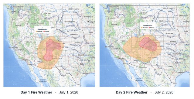
Critical Fire Weather Outlook: SPC Flags Dangerous Conditions June 30 Through July 2, 2026
Critical fire weather conditions are in place across portions of the United States from June 30 through July 2, 2026, according to a series of Day 1 and Day 2 Fire Weather Outlooks issued by the…