View All Articles

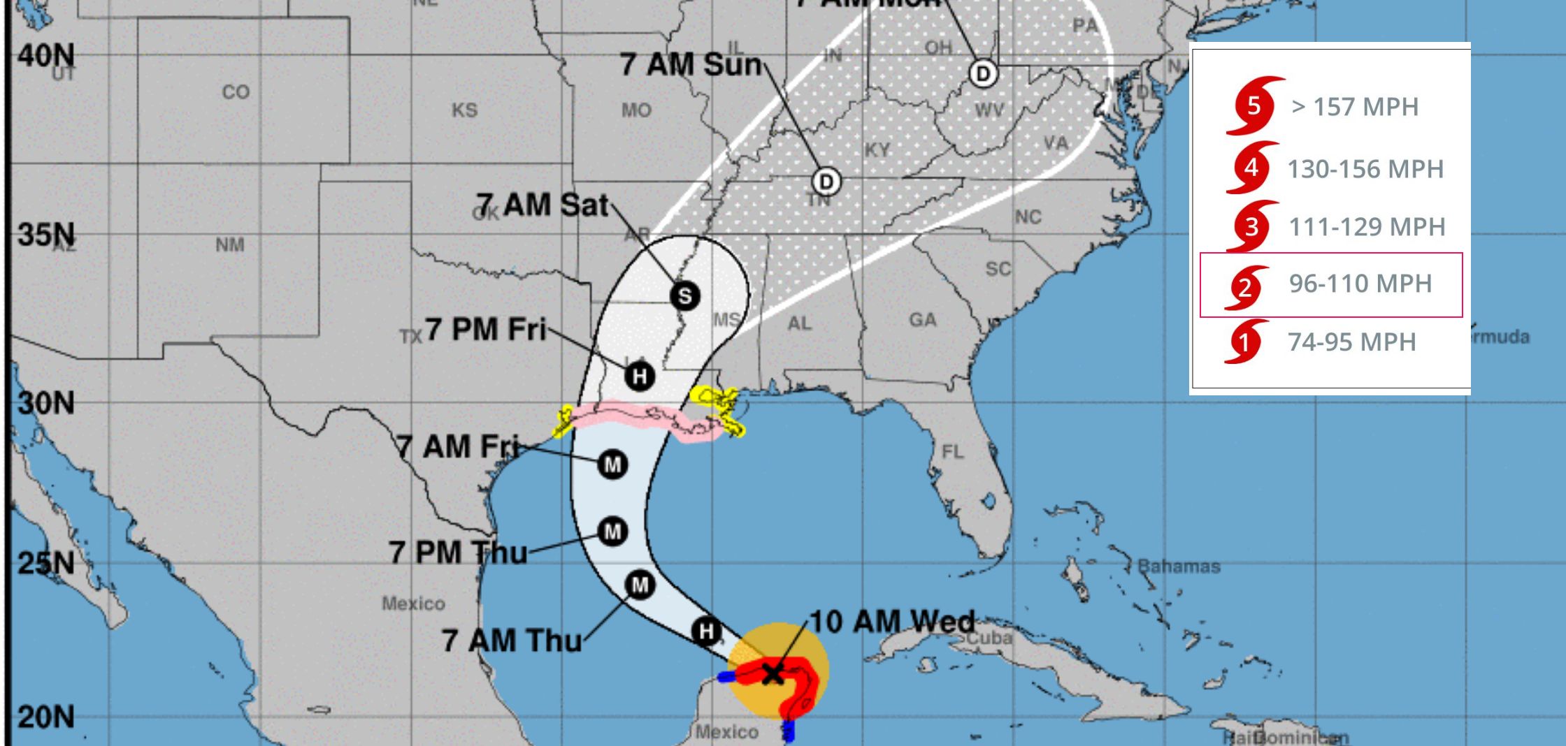
Hurricane Delta 11:00 am October 7, 2020 Advisory 12 Update

Advisory 12 for Hurricane Delta updated at 11:00 am EDT Wednesday October 7, 2020:

As of 11:00 am EDT Hurricane Delta was strong category 2 hurricane with sustained winds of 105 MPH and was located 65 Miles WSW of Cabo Catoche Mexico.

Key Forecast Information:

Life-threatening storm surge and dangerous winds will continue within portions of the northern Yucatan peninsula of Mexico into early afternoon.  Heavy rainfall, which could lead to significant flash flooding, will affect northern Yucatan Peninsula through early Thursday. Delta is expected to grow in size as it approaches the northern Gulf Coast, where there is an increasing likelihood of life-threatening storm surge and dangerous hurricane-force winds beginning Friday, particularly for portions of the Louisiana coast.  Storm Surge and Hurricane Watches are in effect, and residents in these areas should follow advice given by local officials. Flash, urban, small stream, and river flooding is likely Friday through Saturday from portions of the central Gulf Coast northward into portions of Lower middle Mississippi Valley. As Hurricane Delta moves farther inland, additional heavy rainfall is expected in the Ohio Valley and Mid Atlantic this weekend. To view local forecast and severe weather warnings in your area click here.

Related Articles:

This entry was posted in Weather Articles and tagged , , , . Bookmark the permalink.

Leave a Reply

Read More

Hawaii tropical storm forecast track for Potential Tropical Cyclone One-C on August 13, 2026, showing the National Hurricane Center forecast cone crossing the Hawaiian Islands from Friday night into Monday with the center passing near Hilo and Honolulu

Hawaii Tropical Storm Threat: Potential Tropical Cyclone One-C Targets the Islands

Forecast track and cone for Potential Tropical Cyclone One-C, valid 12:00 UTC August 13, 2026 (2 a.m. HST). The track carries the center from east-southeast of the Big Island on Thursday to near or over the…

Read More

Iowa Illinois severe thunderstorms SPC Day 1 categorical risk map for August 13, 2026, showing a Slight Risk from Des Moines across Cedar Rapids, Davenport, Peoria, and Champaign, with a Marginal Risk wrapping from the central Plains into Indiana, Ohio, and Kentucky

Iowa Illinois Severe Thunderstorms: Slight Risk of Damaging Wind and Hail August 13, 2026

Iowa Illinois severe thunderstorms are the top convective concern in the NOAA Storm Prediction Center's Day 1 Outlook issued at 05:58 UTC on August 13, 2026. The SPC has drawn a Slight Risk, the second of…

Read More

Plains severe thunderstorms SPC categorical risk map for August 12, 2026, showing a Slight Risk from the northern and central High Plains across Nebraska and Iowa into Illinois, Indiana, and the lower Ohio Valley

Plains Severe Thunderstorms: Slight Risk of Large Hail and Damaging Wind From Iowa to the High Plains, August 12, 2026

Plains severe thunderstorms are the top weather story for Wednesday, August 12, 2026. The NOAA Storm Prediction Center has issued a Slight Risk, the second of five severe categories, from the central and northern High Plains…

Read More

Leave a Reply


