View All Articles

Hurricane Delta 5:00 pm October 8, 2020 Advisory 17 Update

Advisory 17 for Hurricane Delta updated at 5:00 pm EDT Thursday October 8, 2020:

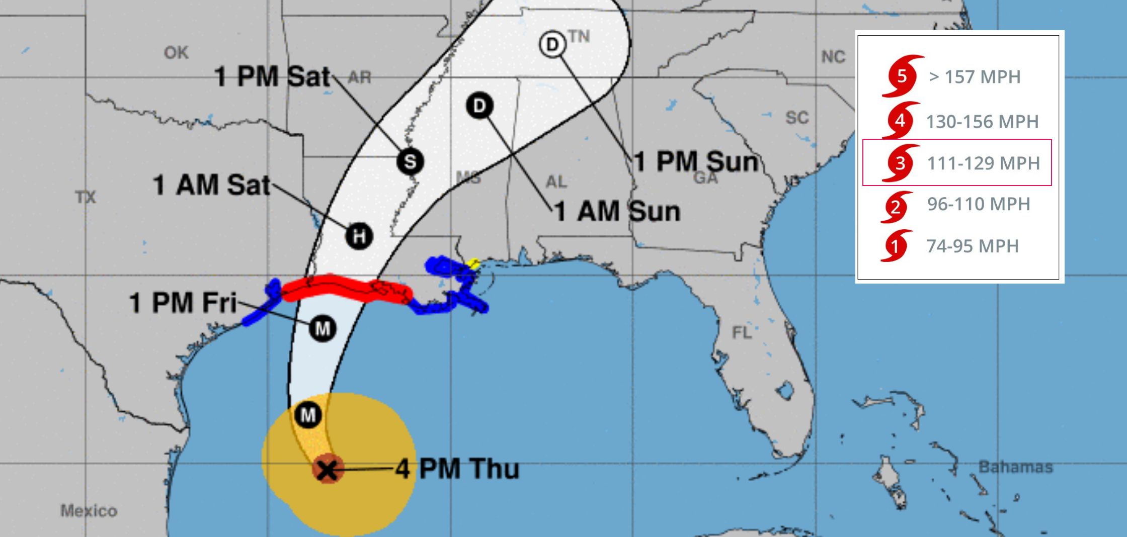
As of 5:00 pm EDT Hurricane Delta was a major category 3 hurricane with sustained winds of 115 MPH (185 KMH) and was located 345 miles S of Cameron Louisiana.  Landfall is currently forecast along Louisiana coast  sometime Friday afternoon.  For the latest hurricane warnings click here and enter desired location.

Key Forecast Information:

Life-threatening storm surge is expected near and east of where Delta makes landfall Friday, and a Storm Surge Warning is in effect from High Island, Texas, to Ocean Springs, Mississippi  The highest inundation of 7 to 11 ft is expected somewhere between Rockefeller Wildlife Refuge and Morgan City, Louisiana.  Residents in the warning area should promptly follow advise given by local officials.  The storm surge risk remains high despite the forecast decrease in intensity before land fall since Delta is expected to grow in size. Hurricane-force winds are expected Friday afternoon and evening somewhere within the Hurricane Warning area between High Island, Texas, and Morgan City Louisiana.  Hurricane force winds will also spread inland across portions of southern Louisiana near the path of Delta’s center Friday evening and Friday night. Heavy rain will lead to significant flash flooding and minor to major river flooding in parts of Louisiana Friday and Saturday.  Additional flooding is expected across potions of the central Gulf Coast into the Lower Mississippi Valley. To view local forecast and severe weather warnings in your area click here.

Related Articles:

This entry was posted in Weather Articles and tagged , , , . Bookmark the permalink.

Leave a Reply

Read More

NOAA Storm Prediction Center categorical severe weather outlook for July 21, 2026, showing an Enhanced Risk (orange) over the Upper Ohio Valley into the Mid-Atlantic, ringed by Slight (yellow) and Marginal (green) risk areas across the eastern United States.

Upper Ohio Valley Severe Weather: Enhanced Risk July 21, 2026

Upper Ohio Valley severe weather is the headline threat on July 21, 2026, as the NOAA Storm Prediction Center (SPC) has issued an Enhanced Risk stretching from the Ohio Valley through the Mid-Atlantic and into the…

Read More

Upper Midwest severe thunderstorms categorical risk map for July 20, 2026, showing an SPC Enhanced Risk from Minnesota and Iowa across Wisconsin to the Great Lakes.

Upper Midwest Severe Thunderstorms: Enhanced Risk July 20, 2026

Upper Midwest severe thunderstorms are threatening Minnesota, Wisconsin, Iowa, Upper Michigan, and the broader Great Lakes region today, July 20, 2026, with the NOAA Storm Prediction Center placing the area under an Enhanced Risk, the third…

Read More

SPC Day 1 categorical severe weather outlook for July 19, 2026, showing Slight Risk areas for Southeast severe thunderstorms across the Carolinas, north Georgia, and southern Virginia, plus the Dakotas and western Minnesota.

Southeast Severe Thunderstorms and Dakotas Hail Threat: SPC Outlook for July 19, 2026

Southeast severe thunderstorms are the lead hazard in today's Storm Prediction Center Day 1 Convective Outlook, issued July 19, 2026, with the SPC placing a Slight Risk, the second of five severe categories (level 2 of…

Read More

Leave a Reply


