
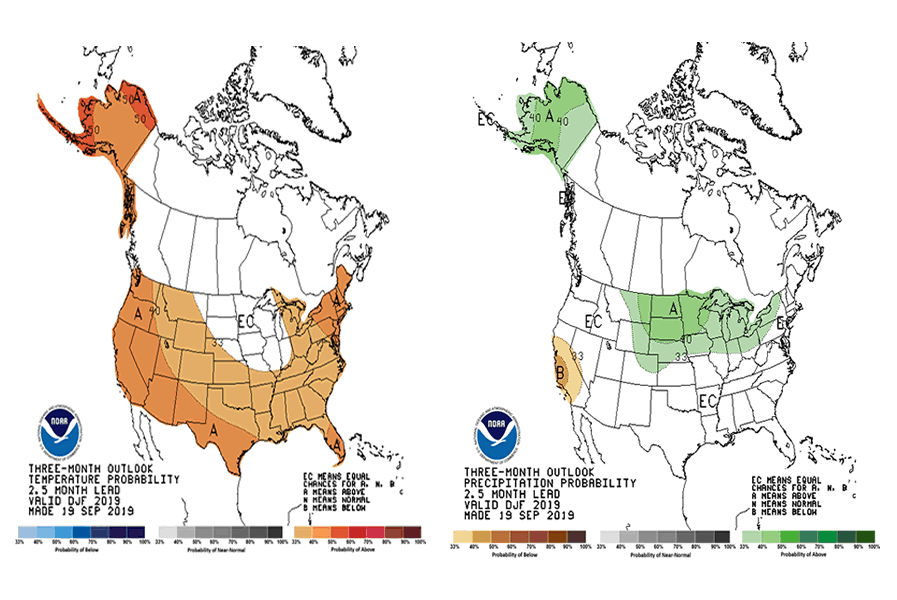
 NOAA: The October-November-December (OND) 2019 temperature outlook favors above normal temperatures throughout the entire forecast domain, although
probabilities vary. The highest regional probabilities for above normal temperatures are forecast across parts of the Southwest, the Northeast, and the North Slope of Alaska. Probabilities for above normal temperatures are lowest from the northern Great Plains and Upper Mississippi Valley to interior portions of the east-central Gulf Coast region, and for interior parts of southern Alaska.
The OND 2019 precipitation outlook indicates that above normal seasonal total precipitation is favored near the Atlantic Coast from Florida to New Jersey, much of the west-central and central CONUS, and Alaska (excluding the Panhandle). Below normal precipitation is favored over the north-central portion of the West Coast.
Equal chances (EC; white areas) of below, near, and above normal are forecast in areas where the likelihood of seasonal mean temperatures or seasonal total precipitation amounts are expected to be similar to their climatological probabilities.
Related Articles:
NOAA: The October-November-December (OND) 2019 temperature outlook favors above normal temperatures throughout the entire forecast domain, although
probabilities vary. The highest regional probabilities for above normal temperatures are forecast across parts of the Southwest, the Northeast, and the North Slope of Alaska. Probabilities for above normal temperatures are lowest from the northern Great Plains and Upper Mississippi Valley to interior portions of the east-central Gulf Coast region, and for interior parts of southern Alaska.
The OND 2019 precipitation outlook indicates that above normal seasonal total precipitation is favored near the Atlantic Coast from Florida to New Jersey, much of the west-central and central CONUS, and Alaska (excluding the Panhandle). Below normal precipitation is favored over the north-central portion of the West Coast.
Equal chances (EC; white areas) of below, near, and above normal are forecast in areas where the likelihood of seasonal mean temperatures or seasonal total precipitation amounts are expected to be similar to their climatological probabilities.
Related Articles:
NOAA: Early Winter Weather Forecast For 2019 / 2020
NOAA: The October-November-December (OND) 2019 temperature outlook favors above normal temperatures throughout the entire forecast domain, although
probabilities vary. The highest regional probabilities for above normal temperatures are forecast across parts of the Southwest, the Northeast, and the North Slope of Alaska. Probabilities for above normal temperatures are lowest from the northern Great Plains and Upper Mississippi Valley to interior portions of the east-central Gulf Coast region, and for interior parts of southern Alaska.
The OND 2019 precipitation outlook indicates that above normal seasonal total precipitation is favored near the Atlantic Coast from Florida to New Jersey, much of the west-central and central CONUS, and Alaska (excluding the Panhandle). Below normal precipitation is favored over the north-central portion of the West Coast.
Equal chances (EC; white areas) of below, near, and above normal are forecast in areas where the likelihood of seasonal mean temperatures or seasonal total precipitation amounts are expected to be similar to their climatological probabilities.
Related Articles:
Read More

Panama Earthquake: Magnitude 7.7 Strikes Near Pitaloza Arriba, USGS Issues RED Alert
USGS ShakeMap of the M7.7 Panama earthquake. The star marks the epicenter; red and orange contours show the strongest estimated shaking. Source: U.S. Geological Survey. A powerful Panama earthquake struck the Azuero Peninsula on Friday, October…

Hurricane Isaias Landfall Expected Tonight on the Northern Gulf Coast as Storm Nears Major Hurricane Strength
Hurricane Isaias position at 7 AM CDT Friday, October 9, 2026, with the NHC forecast track and cone toward the northern Gulf Coast and active coastal and inland warnings. Map: iAlert.com Hurricane Isaias landfall is expected…

Florida Panhandle Tornado Risk: SPC Slight Risk as Hurricane Isaias Nears Pensacola, Oct 9, 2026
Florida Panhandle tornado risk headlines the NOAA Storm Prediction Center Day 1 Convective Outlook valid Friday, October 9, 2026, issued 05:37 UTC (1:37 am EDT / 12:37 am CDT). It places a Slight Risk, level 2…