
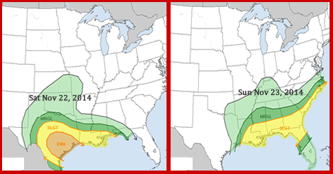
 A low pressure system will move east from the Plains bringing with it warmer air and likely trigger severe thunderstorms and possible tornadoes over the Thanksgiving travel weekend November 22 & 23rd.
High risk areas for severe weather will be from Texas into the Lower Mississippi Valley Saturday before moving into southeastern states Sunday. Damaging winds, large hail, locally heavy rain, and tornadoes are possible.
Stay ahead of severe weather and sign-up for email and/or text message alerts from iAlert.com.
A low pressure system will move east from the Plains bringing with it warmer air and likely trigger severe thunderstorms and possible tornadoes over the Thanksgiving travel weekend November 22 & 23rd.
High risk areas for severe weather will be from Texas into the Lower Mississippi Valley Saturday before moving into southeastern states Sunday. Damaging winds, large hail, locally heavy rain, and tornadoes are possible.
Stay ahead of severe weather and sign-up for email and/or text message alerts from iAlert.com.
Severe Weather Likely for Southeast and Gulf States This weekend; Texas, Louisiana, Mississippi at High Risk
Severe Weather Likely for Southeast and Gulf States This weekend; Texas, Louisiana, Mississippi at High Risk. Map below shows areas of risk below….
A low pressure system will move east from the Plains bringing with it warmer air and likely trigger severe thunderstorms and possible tornadoes over the Thanksgiving travel weekend November 22 & 23rd.
High risk areas for severe weather will be from Texas into the Lower Mississippi Valley Saturday before moving into southeastern states Sunday. Damaging winds, large hail, locally heavy rain, and tornadoes are possible.
Stay ahead of severe weather and sign-up for email and/or text message alerts from iAlert.com.
A low pressure system will move east from the Plains bringing with it warmer air and likely trigger severe thunderstorms and possible tornadoes over the Thanksgiving travel weekend November 22 & 23rd.
High risk areas for severe weather will be from Texas into the Lower Mississippi Valley Saturday before moving into southeastern states Sunday. Damaging winds, large hail, locally heavy rain, and tornadoes are possible.
Stay ahead of severe weather and sign-up for email and/or text message alerts from iAlert.com.
This entry was posted in Weather Articles and tagged Gulf states, louisiana, louisiana weather, mississippi, mississippi weather, risk, severe thunderstorm, Severe Thunderstorm Warning, severe thunderstorms, severe weather, severe weather alerts, severe weather alerts by email, severe weather threat, Texas, Texas weather, Tornado, Tornado Warning, tornadoes. Bookmark the permalink.
Read More
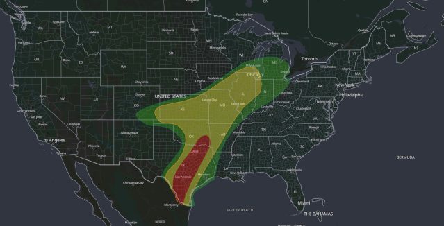
Moderate Risk Flash Flood: Dangerous Rain for Texas, Oct 1
iAlert weather analysis view of the WPC Day 1 Excessive Rainfall Outlook valid 7:00 am CDT Thursday, October 1, 2026, to 7:00 am CDT Friday, October 2. The innermost area is the Level 3 of 4…
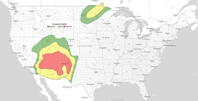
Moderate Risk Flash Flooding in the Southwest: WPC Level 3 of 4 Excessive Rainfall Outlook for September 28, 2026
WPC Day 1 Excessive Rainfall Outlook, 16Z update issued 11:33 am EDT Monday, September 28, 2026. Red marks the Moderate Risk flash flooding area (level 3 of 4) across the Four Corners, yellow the Slight Risk…
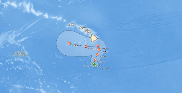
Big Island Hurricane Threat: Tropical Depression Fifteen-E Forecast to Reach Major Hurricane Strength by Saturday
Forecast cone for the Big Island hurricane threat: Tropical Depression Fifteen-E is forecast to pass about 80 miles southeast of South Point as a Category 3 hurricane early Saturday. Source: NOAA National Hurricane Center, Advisory 12,…