The June 2012 Derecho: Chicago to Washington DC
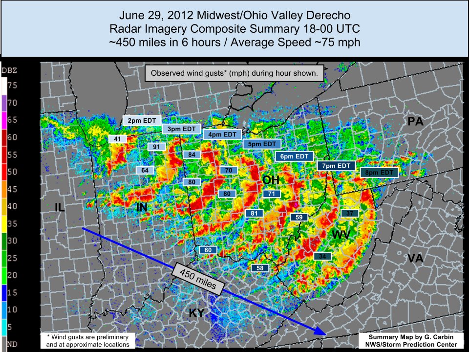
The June 29, 2012 radar imagery composite below shows an actual derecho that started near Chicago and pushed into Washington DC in about 12 hours. Notice the largest width of the storm is over 240 miles, the storm path in the image covers nearly 450 miles (the full path extended 700 miles into DC), and the signature bow echo is clearly visible. That storm killed 22 people and left more than 4 million customers without power across 10 states, with many outages lasting a week during a record heat wave.Official Derecho Criteria
- Fast-moving, long-lived windstorm
- Violent thunderstorms coupled together in a continuous line or cluster
- Wind gusts of 58 mph or greater along most of the path
- Wind damage extending more than 240 miles
How a Derecho Forms
Derechos develop from organized complexes of thunderstorms known as mesoscale convective systems. As storms mature, rain-cooled air descends and spreads out along the ground, forcing new storms to fire continuously along the leading edge. A channel of fast-moving air behind the line, the rear-inflow jet, descends to the surface and drives the damaging winds. When this process sustains itself for hours, the result is a derecho. Most derechos occur from May through August, favoring the Corn Belt, Ohio Valley, and Mid-Atlantic. The August 2020 derecho that struck Iowa produced estimated gusts to 140 mph near Cedar Rapids and became the costliest thunderstorm event in U.S. history at over $11 billion in damage, proof that straight-line winds can rival a hurricane. Meteorologists recognize two types. Progressive derechos are summer events: a relatively narrow line racing along the northern edge of a hot, humid air mass, like the 2012 and 2020 events. Serial derechos are broader, multi-bow systems driven by strong spring or fall low-pressure systems, and they more often come with embedded tornadoes.Derecho vs. Tornado: How the Damage Differs
Derecho damage is straight-line wind damage: trees, crops, and debris all fall in the same direction, pushed by winds moving one way. Tornado damage is rotational, with debris scattered in converging or swirling patterns. NWS survey teams use this distinction on the ground to determine whether damage came from a tornado or from a derecho’s straight-line winds, which are often just as destructive.| Wind Event | Typical Winds |
|---|---|
| Severe thunderstorm threshold | 58 mph |
| Strong derecho | 75–100+ mph (gusts to 140 mph recorded in 2020) |
| Category 1–2 hurricane | 74–110 mph |
| EF1–EF2 tornado | 86–135 mph |
Derecho Warnings: What You Will Actually Receive
There is no dedicated derecho watch, warning, or advisory. Derecho warnings are embedded in Severe Thunderstorm Warnings. In your iAlert.com member account, if you have selected to receive Severe Weather alerts by email or text message, you will be notified of an approaching derecho. To learn more about the alert types iAlert offers, see what alerts you can receive with iAlert. Treat a Severe Thunderstorm Warning during a derecho event with the same urgency as a tornado warning: get indoors, away from windows, and expect extended power outages.Derecho FAQ
How often do derechos occur?
The Corn Belt and Ohio Valley average one to two derechos per year. Roughly 70% occur from May through August.Is a derecho as dangerous as a tornado?
A strong derecho produces hurricane-force winds over an area hundreds of miles long, far larger than any tornado path. Total damage and power outages from a major derecho routinely exceed those of most tornado events.How much warning will I get before a derecho?
Often 1 to 3 hours as Severe Thunderstorm Warnings are issued ahead of the advancing line, and the SPC’s severe weather outlook frequently flags the threat a day or more out. That is enough time to act if the alert reaches you immediately, which is exactly what email and text alerts are for.Get Severe Weather Alerts by Text, Email, Phone-call
Receive real-time email, text, and voice call notifications when a Severe
Thunderstorm Watch or Warning, the alerts that carry derecho events, is issued for your area.
Sign Up Free ›


