View All Articles

Eastern U.S. Flooding Potential with Tropical Storm Andrea

4:00 PM Thursday June 6, 2013:  Tropical Storm Andrea is forecast to be a major rain maker over the entire eastern U.S. and people in the path of this tropical storm, especially those in flood prone areas, need to take action now to prepare for flooding from Tropical Storm Andrea. Below is the most recent 5 day precipitation map issued by NOAA’s National Weather Service which will correlate closely with those areas of highest potential for flooding, as shown by the higher amounts on the map.  
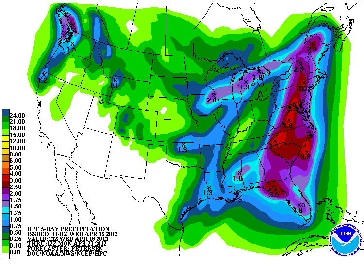
Tropical Storm Andrea 5 Day Precipitation Totals (click to enlarge)

Please monitor this evolving situation at iAlert.com, by watching local news reports, or by listening to NOAA Weather Radio.

If you have captured pictures of this or any other weather related events please consider sharing them and your story as an iAlert News Reporter….

More About iAlert News Reporter | Sign-up For iAlert News Reporter

This entry was posted in Weather Articles and tagged , , , , , , . Bookmark the permalink.

Leave a Reply

Read More

NOAA Storm Prediction Center categorical severe weather outlook for July 21, 2026, showing an Enhanced Risk (orange) over the Upper Ohio Valley into the Mid-Atlantic, ringed by Slight (yellow) and Marginal (green) risk areas across the eastern United States.

Upper Ohio Valley Severe Weather: Enhanced Risk July 21, 2026

Upper Ohio Valley severe weather is the headline threat on July 21, 2026, as the NOAA Storm Prediction Center (SPC) has issued an Enhanced Risk stretching from the Ohio Valley through the Mid-Atlantic and into the…

Read More

Upper Midwest severe thunderstorms categorical risk map for July 20, 2026, showing an SPC Enhanced Risk from Minnesota and Iowa across Wisconsin to the Great Lakes.

Upper Midwest Severe Thunderstorms: Enhanced Risk July 20, 2026

Upper Midwest severe thunderstorms are threatening Minnesota, Wisconsin, Iowa, Upper Michigan, and the broader Great Lakes region today, July 20, 2026, with the NOAA Storm Prediction Center placing the area under an Enhanced Risk, the third…

Read More

SPC Day 1 categorical severe weather outlook for July 19, 2026, showing Slight Risk areas for Southeast severe thunderstorms across the Carolinas, north Georgia, and southern Virginia, plus the Dakotas and western Minnesota.

Southeast Severe Thunderstorms and Dakotas Hail Threat: SPC Outlook for July 19, 2026

Southeast severe thunderstorms are the lead hazard in today's Storm Prediction Center Day 1 Convective Outlook, issued July 19, 2026, with the SPC placing a Slight Risk, the second of five severe categories (level 2 of…

Read More

Leave a Reply


