| Category | Wind Speed | Description |
|---|---|---|
| Category 1 | 74–95 mph (119–153 km/h) | Some damage to roofing, siding, and trees. Power outages likely. |
| Category 2 | 96–110 mph (154–177 km/h) | Extensive roof and siding damage. Widespread power loss expected. |
| Category 3 (Major) | 111–129 mph (178–208 km/h) | Devastating damage. Many trees down. Water and power out for days to weeks. |
| Category 4 (Major) | 130–156 mph (209–251 km/h) | Catastrophic damage. Most trees and power poles down. Long outages likely. |
| Category 5 (Major) | 157+ mph (252+ km/h) | Catastrophic. Homes destroyed. Area may be uninhabitable for weeks or months. |
Saffir-Simpson Hurricane Wind Scale
The Saffir-Simpson Hurricane Wind Scale is a 1 to 5 rating based on a hurricane’s sustained wind speed. This scale estimates potential property damage. Hurricanes reaching Category 3 and higher are considered major hurricanes because of their potential for significant loss of life and damage. Category 1 and 2 storms are still dangerous, however, and require preventative measures. In the western North Pacific, the term “super typhoon” is used for tropical cyclones with sustained winds exceeding 150 mph.
Understanding the Saffir-Simpson Hurricane Wind Scale can help you, your community and, emergency planners better prepare for the impacts of tropical cyclones.. Keep in mind that wind speed is just one factor storm surge, heavy rainfall, and inland flooding can be just as dangerous, this wind scale offers a helpful a framework for anticipating structure damage and taking necessary precautions. Regardless of category, all hurricanes have the potential to disrupt lives and property. Staying informed, having an emergency plan in place before a storm threatens, and following official warnings can make all the difference.
This entry was posted in Basic Meteorology, Weather Articles and tagged Cyclone, hurricanes, Saffir-Simpson, Tropical, tropical cyclone, typhoon, wind, Wind Scale. Bookmark the permalink.
Read More
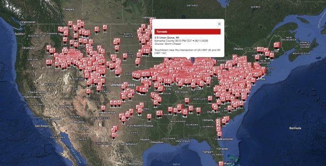
2,392 Storm Reports: A Dangerous 3-Day U.S. Outbreak
From June 10 to 12, 2026, the U.S. recorded 2,392 storm reports across 41 states, one of the busier three-day spans of the season, alongside more than 1,400 National Weather Service watches, warnings, and advisories. The…

El Nino Forecast: NOAA Declares El Nino Has Formed and May Strengthen This Fall
El Nino forecast updates from NOAA confirm that El Nino has officially developed in the tropical Pacific Ocean, and federal forecasters expect it to intensify through the coming months. NOAA issued a formal El Nino Advisory…
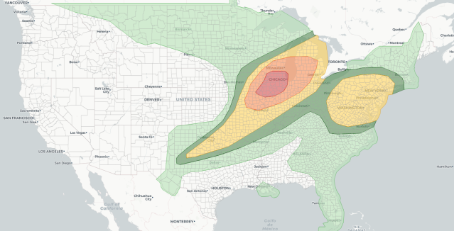
Midwest Severe Thunderstorms Outbreak: Tornadoes, Hurricane-Force Winds, and 400K Without Power
Midwest severe thunderstorms are producing a significant outbreak across a multistate region today, June 11, 2026, with the Storm Prediction Center declaring a Moderate Risk for parts of eastern Iowa and northern Illinois, one of the…