 Midwest severe thunderstorms are producing a significant outbreak across a multistate region today, June 11, 2026, with the Storm Prediction Center declaring a Moderate Risk for parts of eastern Iowa and northern Illinois, one of the higher threat
categories the SPC issues. The event has already resulted in a destructive derecho, widespread power outages exceeding 400,000 customers, reported tornadoes, and large hail reported up to baseball size.
Midwest severe thunderstorms are producing a significant outbreak across a multistate region today, June 11, 2026, with the Storm Prediction Center declaring a Moderate Risk for parts of eastern Iowa and northern Illinois, one of the higher threat
categories the SPC issues. The event has already resulted in a destructive derecho, widespread power outages exceeding 400,000 customers, reported tornadoes, and large hail reported up to baseball size.
What the SPC Is Warning: Outbreak-Level Midwest Severe Thunderstorms
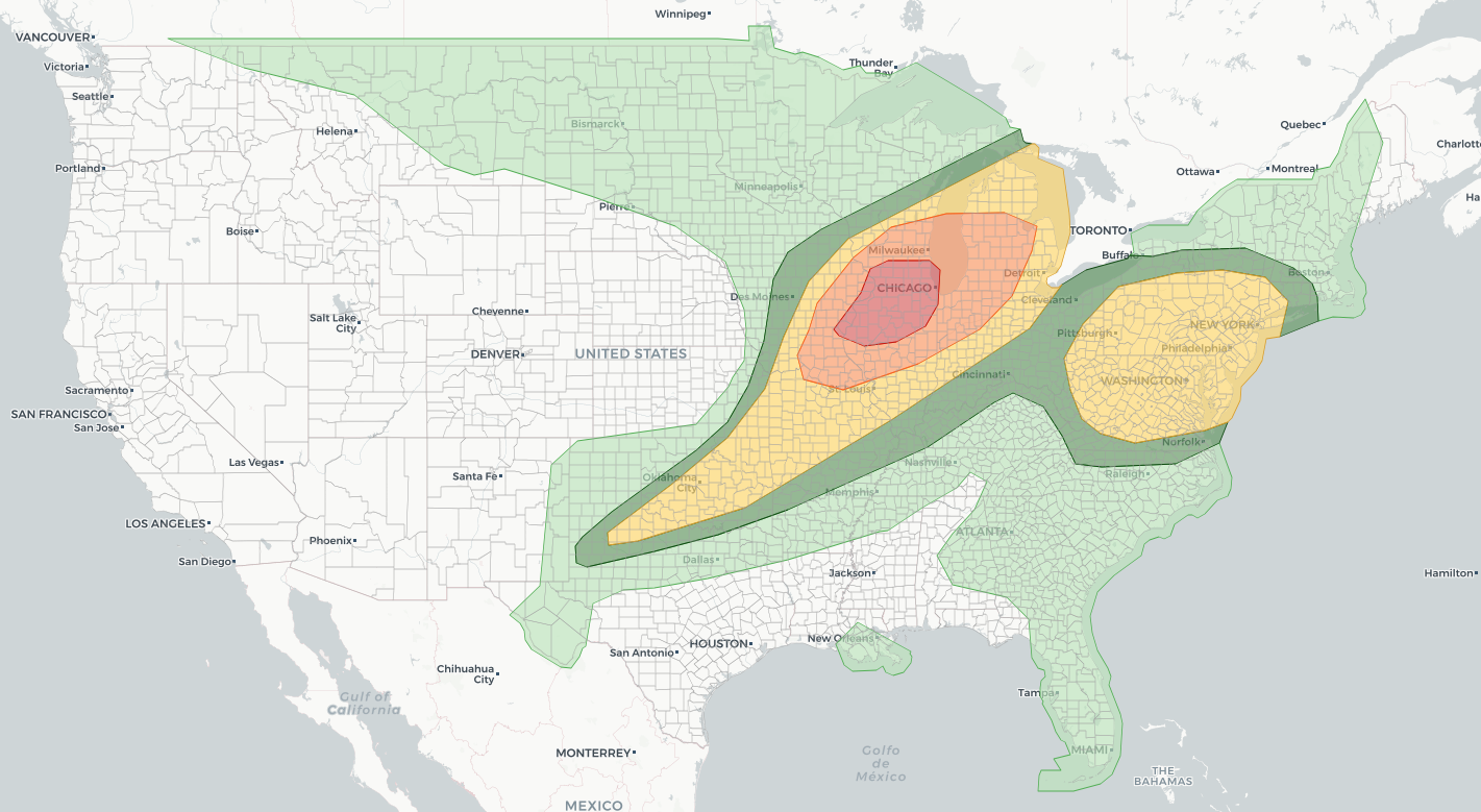
The SPC issued a formal Public Severe Weather Outlook early Thursday morning, using the word “outbreak” to describe the expected threat. The primary hazards identified by forecasters include widespread damaging winds, with some gusts potentially reaching hurricane force, defined as 74 mph or greater. Several tornadoes are anticipated, with a couple expected to be intense. Isolated large hail up to baseball size, roughly 2.75 inches in diameter, rounds out the threat. The areas most at risk span northern and central Illinois, northern and eastern Missouri, eastern Iowa, southern and eastern Wisconsin, northwest Indiana, and lower Michigan. The SPC’s Day 1 Convective Outlook placed the Moderate Risk corridor specifically over eastern Iowa and northern Illinois, with a broader Slight Risk extending into the Northeast and Mid-Atlantic states as the system tracks eastward. A Tornado Watch covering portions of Iowa, Illinois, and Missouri was issued Thursday morning and remained active into the afternoon. The SPC issued Tornado Watch, initially covering ten counties in central and south-central Iowa through 3:00 PM CDT. A subsequent SPC Mesoscale Discussion noted that severe wind gusts remained likely across eastern Iowa, northwest Illinois, and northeast Missouri, and flagged a developing tornado risk from northeast Missouri into west-central Illinois as the mesoscale convective system evolved.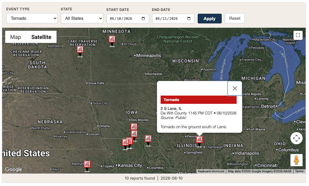
Derecho Damage and Power Outages Across the Region
The fast-moving wind-damage event has already been characterized as a derecho, a term that describes a widespread, long-lived wind storm associated with a line of severe thunderstorms. According to reporting from FOX Weather, more than 400,000 residents across the Midwest lost power as a result of the destructive winds. Derechos can produce damage swaths hundreds of miles long, and their straight-line wind damage is often mistaken for tornado damage on the ground. About 40 million people were in the path of the severe weather threat heading into Thursday, according to ABC News, reflecting how broad the outbreak footprint is across the central United States. NBC News reported that the severe, humid conditions extended into the Northeast as the storm system pushed east.Meteorologist’s take
This event has the classic signature of a high-end early-summer outbreak in the Midwest. A strong mid-level jet combined with substantial low-level wind shear and abundant moisture creates an environment where storms can organize quickly into long-lived mesoscale convective systems capable of producing all three major hazard types simultaneously: tornadoes, damaging straight-line winds, and large hail. The SPC’s decision to issue a Public Severe Weather Outlook using the word “outbreak” is significant. The agency reserves that language for events where widespread severe weather is expected over a large area, not just isolated strong storms. The SPC’s decision to hoist a Tornado Watch over the corridor signals that storm-scale rotation is increasing beyond initial expectations. Residents in the watch area should treat any Tornado Warning with maximum urgency.How to Stay Safe During a Midwest Severe Thunderstorms Outbreak
- Move to an interior room on the lowest floor of a sturdy building immediately upon hearing a tornado siren or receiving a Tornado Warning.
- Stay away from windows during any phase of a severe thunderstorm. Flying debris and large hail can shatter glass without warning.
- If a derecho or wind event is occurring, treat downed power lines as energized and keep your distance. Report outages to your utility provider but do not approach lines.
- Have a battery-powered or hand-crank weather radio available as a backup alert source if power fails.
- Check active weather alerts for your area on iAlert so you know exactly which watches and warnings apply to your specific location before and during the storm.
Sources:
- NOAA Storm Prediction Center: Public Severe Weather Outlook, June 11, 2026
- NOAA SPC: Day 1 Convective Outlook, 1300 UTC June 11, 2026
- NOAA SPC: Tornado Watch 311 Status Reports
- NOAA SPC: Mesoscale Discussion 1086, June 11, 2026
- FOX Weather via Google News: Over 400K residents without power after destructive derecho, June 11, 2026
- ABC News via Google News: 40 million people in the Midwest in path of severe weather, possible tornadoes
- NBC News via Google News: Severe thunderstorms and humid weather rip through the Northeast and Midwest
This article summarizes reported conditions as of the time of writing and may not reflect the latest watches, warnings, or storm reports. For official, real-time alerts for your location, always rely on the National Weather Service and iAlert.


