 From June 10 to 12, 2026, the U.S. recorded 2,392 storm reports across 41 states, one of the busier three-day spans of the season, alongside more than 1,400
National Weather Service watches, warnings, and advisories. The standout was a severe thunderstorm outbreak across the Midwest, Great Lakes, and Ohio Valley, which
drove most of the tornadoes, wind damage, and large hail. Separate weather systems were active elsewhere at the same time, so the nationwide totals below capture more than the
Midwest event alone.
The figures come straight from iAlert’s storm reports database, sourced from NWS storm reports, which log spotter, public, emergency manager, and survey reports as they arrive. For the full account of the Midwest event, see our coverage of the Midwest severe
thunderstorms outbreak.
From June 10 to 12, 2026, the U.S. recorded 2,392 storm reports across 41 states, one of the busier three-day spans of the season, alongside more than 1,400
National Weather Service watches, warnings, and advisories. The standout was a severe thunderstorm outbreak across the Midwest, Great Lakes, and Ohio Valley, which
drove most of the tornadoes, wind damage, and large hail. Separate weather systems were active elsewhere at the same time, so the nationwide totals below capture more than the
Midwest event alone.
The figures come straight from iAlert’s storm reports database, sourced from NWS storm reports, which log spotter, public, emergency manager, and survey reports as they arrive. For the full account of the Midwest event, see our coverage of the Midwest severe
thunderstorms outbreak.
What the Storm Reports Show
Nationwide, wind was the dominant threat. Thunderstorm wind damage alone accounted for 1,021 reports, the single largest category, with hundreds more gust and non-thunderstorm wind reports on top of that. Tornadoes, hail, and flooding rounded out an active three days.- 2,392 total reports across 41 states
- 1,021 thunderstorm wind damage reports, plus 334 thunderstorm wind gust reports
- 49 tornadoes, 16 funnel clouds, 2 landspouts, and 3 waterspouts
- 180 hail reports, topping out at a measured 3.50 inches
- 144 flooding reports (110 flash flood, 34 flood) and 283 heavy rain reports
What NWS Warned
The reports are the aftermath. Ahead of them, NWS meteorologists were busy monitoring the storms and alerting the public: more than 1,400 watches, warnings, and advisories over the three days, more than 1,100 of them warnings, alongside numerous special weather statements. The pace matched the storms, busiest on June 11, the same day the reports peaked.- 777 Severe Thunderstorm Warnings, the dominant product, in step with the 1,021 wind-damage reports.
- 133 Tornado Warnings. These often go out the moment radar shows rotation, before a tornado is confirmed on the ground, to give people time to take cover. The confirmed tornado count, 49 as of June 13, is preliminary and expected to rise as storm surveys are completed.
- 91 Flash Flood Warnings and 115 areal flood advisories, matching the 144 flood reports.
- 69 Severe Thunderstorm Watches and 28 Tornado Watches, the broader heads-up issued hours ahead of the line.
June 11 Was the Peak
The weather deteriorated fast and peaked on the middle day. June 11 produced 1,109 reports, June 10 added 1,038, and June 12 tapered to 245 as the system pushed east. Tornado activity tracked the same curve: 15 tornadoes on June 10, then 34 on June 11.The Midwest Was the Center
The Midwest took the brunt. Illinois was the hardest-hit state by a wide margin, with the Chicago metro and the central part of the state, from Peoria to Bloomington to Springfield, hit by wave after wave of severe storms. This region absorbed most of the 49 tornadoes and the bulk of the wind damage, and the reports read like a damage log: roofs peeled off homes and apartment buildings, barns and outbuildings flattened, and trees and power lines down across neighborhoods and rural roads. Michigan, Wisconsin, Iowa, Indiana, and Pennsylvania filled out the hardest-hit band across the Great Lakes and Ohio Valley.
Not all of the day’s reports came from the same storm. Idaho and Wyoming also ran up high totals, but from a separate, non-thunderstorm high-wind event in the northern Rockies. The nationwide tally folds in more than one system.
Widespread Wind Damage
Damaging straight-line winds did the broadest damage in the Midwest. Peak thunderstorm gusts reached 94 mph near Oshkosh, Wisconsin (June 10) and 96 mph near Eva, Oklahoma (June 12). Out west, the separate high-wind event produced a 103 mph non-thunderstorm gust in Wyoming’s Lincoln County high country on June 10.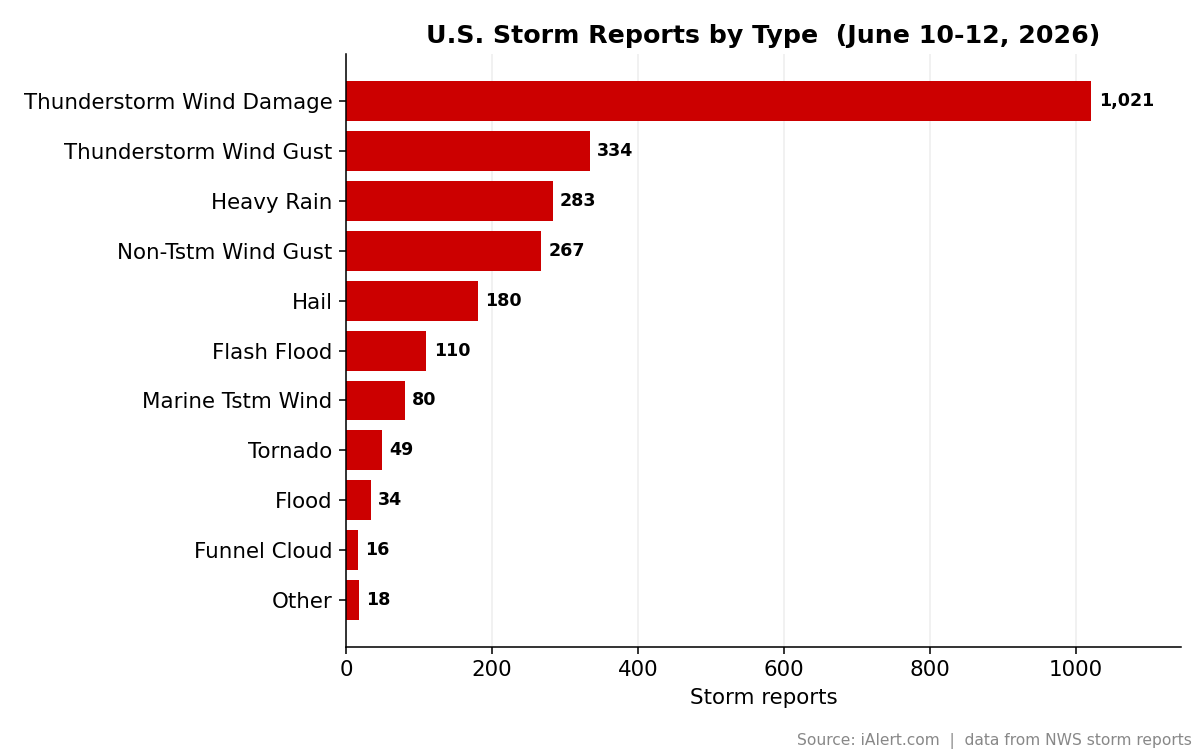
- The roof of a five-story apartment building was torn off in Berwyn, Illinois, in the Chicago metro.
- A semi trailer was tipped over on Interstate 88 south of Maple Park, Illinois.
- An “iconic blue barn” was destroyed near Beaver Dam, Wisconsin.
- Multiple greenhouses were destroyed in Constantine, Michigan.
🔔 Get storm reports the moment they’re issued. iAlert sends tornado, wind, and hail reports for your area by text or email as the NWS issues them. Sign up for storm report alerts.
The Tornado Corridor
The strongest tornado activity ran from eastern Iowa across Illinois and into Indiana and Michigan, especially on June 11. Surveyed tornadoes have so far topped out at EF-1, with peak winds near 110 mph, and more surveys are still to come. Notable confirmed tracks include:- An EF-1 near Springfield, Illinois (Capital Airport, Sangamon County) on June 10, with 110 mph winds and a 20.25-mile path, the longest in the dataset.
- An EF-1 near Ogden, Illinois (Vermilion County) on June 11, 110 mph winds over 13.5 miles.
- An EF-1 near Groveland, Illinois (Tazewell County) on June 11, 105 mph winds over 12.95 miles.
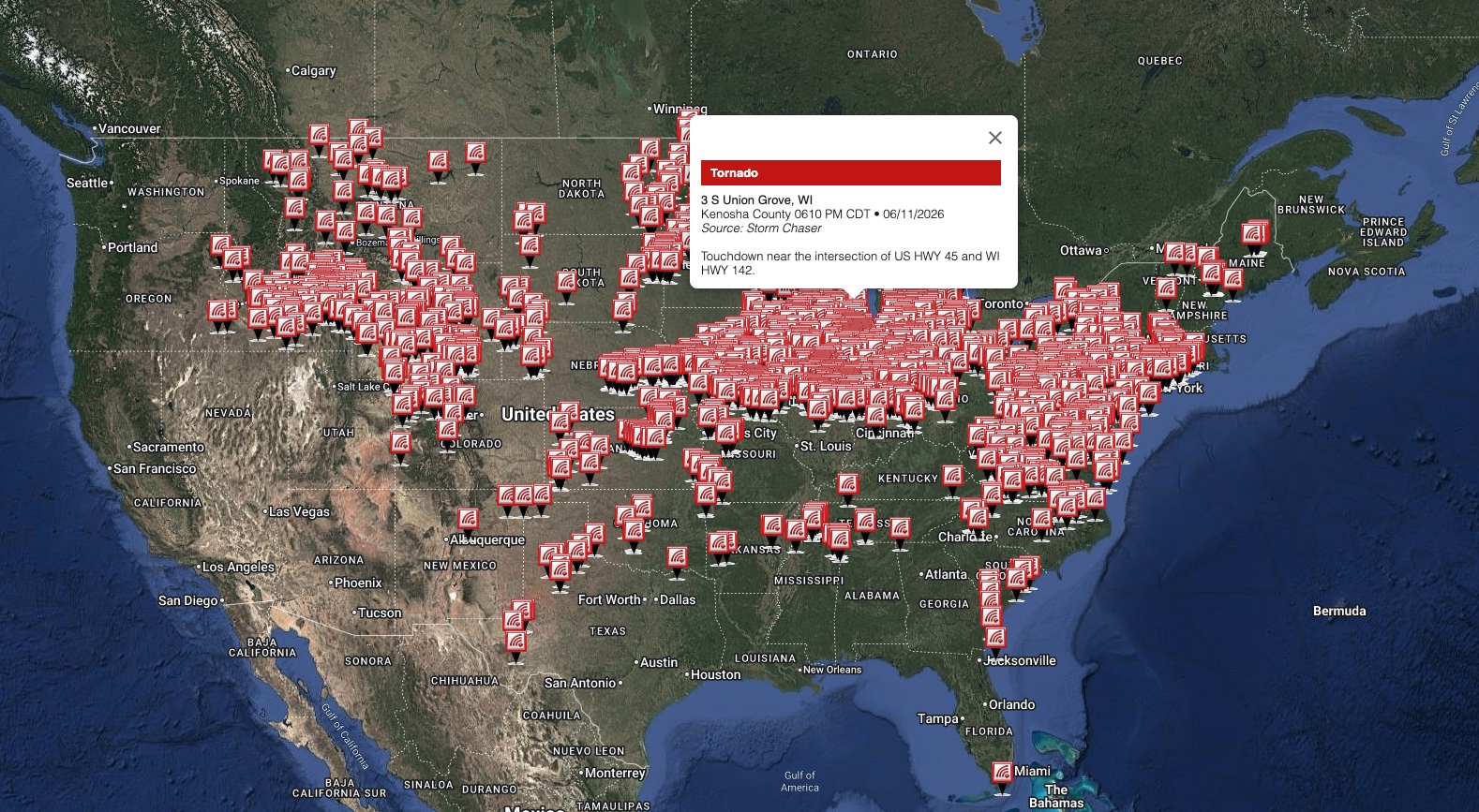
- A storm-chaser-confirmed touchdown near Union Grove, Wisconsin (Kenosha County), shown on the map above.
Very Large Hail on the Western Flank
The biggest hail fell along the outbreak’s western and southern flank, a corridor from Kansas through Nebraska into Iowa, much of it overnight. A measured 3.50-inch stone, larger than a baseball, was reported at Yorktown, Iowa (Page County) at 5:30 AM on June 11, with several 2.50 to 2.75 inch reports across Nebraska’s Phelps and Kearney counties in the pre-dawn hours and across central Kansas on June 10.Meteorologist’s Take
This was a major, fast-moving outbreak, and its full extent is still being assessed. The 49 confirmed tornadoes and the preliminary EF-1 top rating are an early snapshot, not a final count. Damage surveys take days, and as crews reach the hardest-hit areas both the number of tornadoes and some of the ratings can rise.
The dominant signature so far is wind: more than 1,700 wind reports and gusts into the 90s mark a progressive line that raced east across the Great Lakes and Ohio Valley, tearing roofs off buildings and bringing down trees and power lines. At the same time, the very large hail in the Plains and the separate 100+ mph winds out of Wyoming show that more than one weather regime was active across the country at once, with this Midwest outbreak as the centerpiece.
How to Stay Ahead of Severe Weather
- Have two ways to receive warnings, including one that wakes you at night. The largest hail in this event fell between 2 and 6 AM.
- When a Tornado Warning is issued, move to the lowest interior room, away from windows.
- Straight-line winds caused most of the reports here. Treat a Severe Thunderstorm Warning seriously; 90 mph gusts tear roofs off buildings and flip trailers.
- After the storm, watch for flooding. This event logged 144 flood reports, and water on roads kills more people than most other storm hazards.
- Track active watches and warnings in your area on iAlert as conditions evolve.