 El Nino forecast
 updates from NOAA confirm that El Nino has officially developed in the tropical Pacific Ocean, and federal forecasters expect it to intensify through the coming months. NOAA issued a formal El Nino Advisory on June 11, 2026, marking the start of a climate pattern that will influence U.S. weather well into next year.
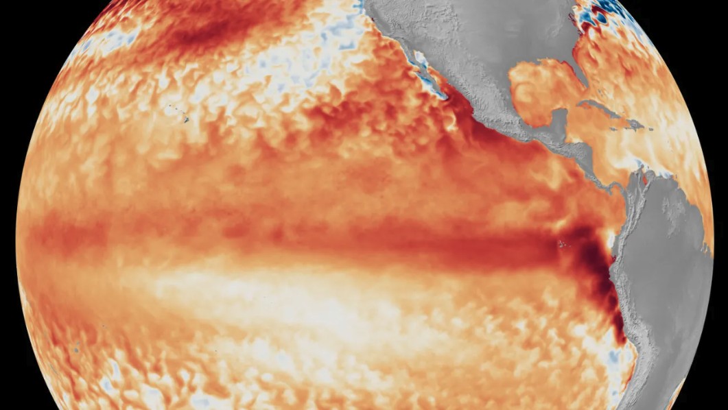
What NOAA’s El Nino Forecast Shows
According to NOAA’s National Weather Service, sea surface temperatures in the monitored region of the equatorial Pacific have already surpassed the 0.5°C above-average threshold required to declare El Nino. Forecasters now place a 63% probability that temperatures in that region will exceed 2.0°C above average by fall, the level NOAA defines as a “very strong” El Nino event.
NOAA also noted an important methodological update tied to this El Nino forecast. In February 2026, the agency officially adopted the Relative Oceanic Nino Index (RONI) to replace the older static Oceanic Nino Index (ONI). Unlike the ONI, which compares ocean temperatures against a fixed 30-year baseline, the RONI updates month to month. NOAA scientists determined that RONI correlates more closely with changes in the Walker Circulation, the massive east-to-west atmospheric flow that drives El Nino’s development, making forecasts more reliable for emergency managers and the public.
How El Nino Affects U.S. Weather This Winter
The El Nino forecast carries significant implications for the continental United States, particularly during the Northern Hemisphere winter when El Nino’s effects are typically strongest. The jet stream over the North Pacific tends to shift southward during El Nino, pushing storm tracks toward the southern tier of the country and increasing the likelihood of both rain and snow across the Southern U.S.
At the same time, the Northern Rockies and the Ohio and Tennessee valleys typically see drier conditions, and the northern United States tends to run warmer than average. High tide flooding risk may also rise, especially along the West Coast, due to elevated sea surface temperatures.
One well-known effect of El Nino on the El Nino forecast for tropical weather: stronger upper-level winds in the Atlantic Basin tend to suppress hurricane development, while the eastern and central Pacific may see increased tropical activity. That trade-off has direct implications for coastal communities across the country.
NOAA also flagged that past strong El Nino events have triggered harmful algal blooms along the West Coast and disrupted the migration of fish and other marine organisms, with warm-water species shifting northward and cold-water species retreating to deeper waters.
Meteorologist’s Take
Every El Nino event is different in its intensity and regional footprint, and forecasters are right to caution that the current El Nino forecast does not guarantee identical outcomes to past strong events. The 63% probability of reaching “very strong” status is significant, but that still leaves meaningful uncertainty heading into fall.
The Walker Circulation is the key atmospheric signal to watch. When that east-to-west airflow breaks down and warm water builds in the eastern equatorial Pacific, the downstream effects on the jet stream become more pronounced. The stronger the sea surface temperature departure, the more reliably those downstream signals tend to play out.
The shift to the RONI index is a meaningful upgrade. A dynamically updating baseline is better suited to a warming ocean, where a static 30-year average can increasingly underrepresent what counts as anomalous. This makes the current El Nino forecast more actionable for planners and emergency managers than past tools allowed.
How to Stay Safe During El Nino Weather
An elevated El Nino forecast means communities across the southern United States should begin preparing now for a potentially active winter storm season. Residents along the West Coast should monitor high tide flooding advisories as sea levels may run higher than normal for extended periods.
- Sign up for location-based weather alerts so you receive warnings the moment hazardous conditions develop in your area. Check active weather alerts on iAlert to stay current throughout the El Nino season.
- Review your home and vehicle emergency kits before fall, stocking supplies for both winter storms and potential flooding.
- Stay informed about drought conditions if you live in the Northern Rockies or Tennessee and Ohio valleys, where drier-than-normal conditions are more likely.
- Coastal residents should consult local tide charts and NOAA high tide flooding outlooks regularly through the winter months.
- Monitor your local weather forecast frequently as the El Nino forecast evolves and seasonal outlooks are updated.
Because the El Nino forecast is a probabilistic outlook covering months ahead, conditions can and will change. Staying connected to reliable, real-time weather alerts is the most practical step any household can take right now.
Sources:


