View All Articles

Hurricane Delta 11:00 am October 9, 2020 Advisory 20 Update, Landfall Forecast

Advisory 20 for Hurricane Delta updated at 11:00 am EDT Friday October 9, 2020:

As of 11:00 am EDT 
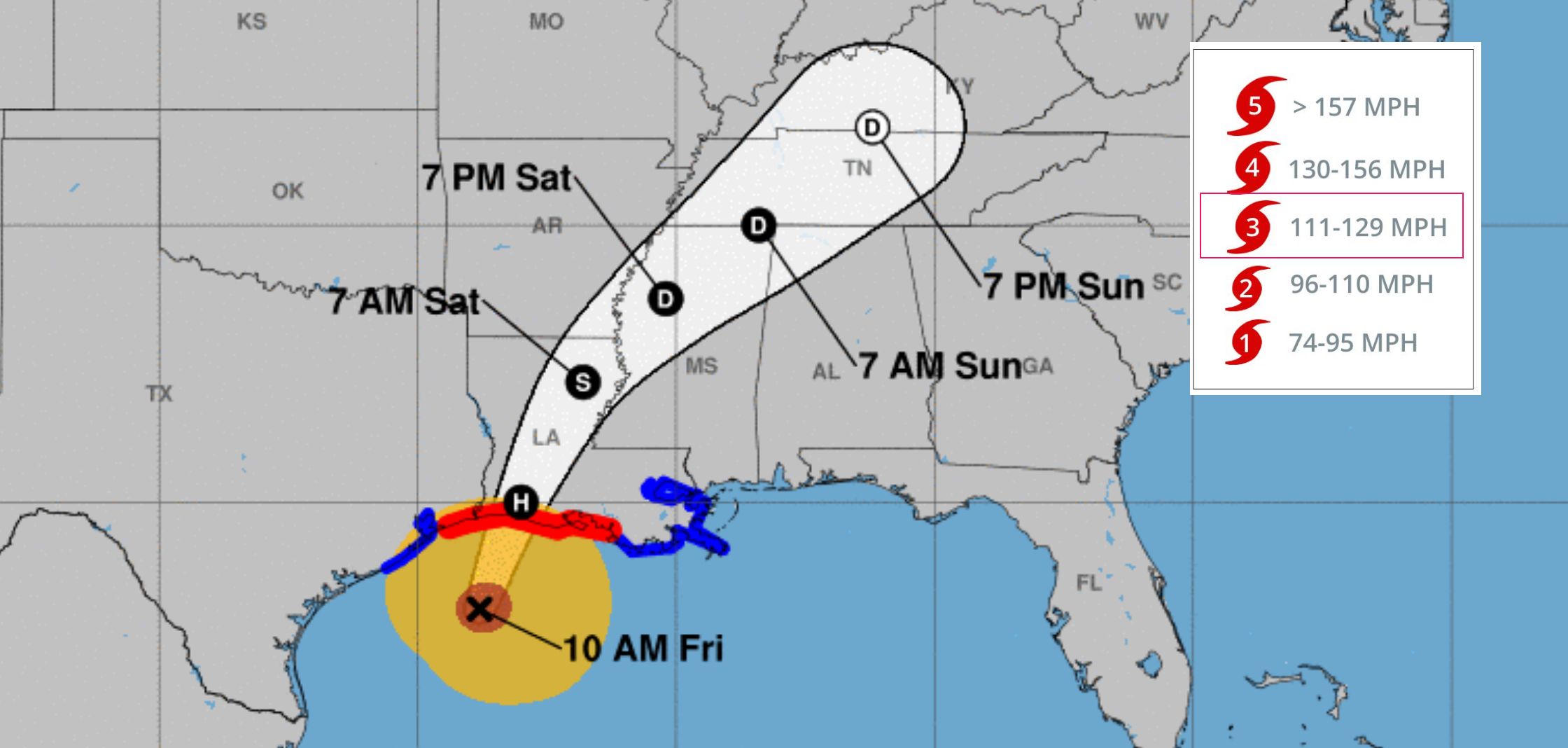
Hurricane Delta remains a major category 3 hurricane with sustained winds of 115 MPH (185 KMH) and was located 130 miles south-southwest of Cameron Louisiana.  Expect hurricane conditions and a life-threatening storm surge to portions of the northern gulf coast later today.  For the latest hurricane warnings click here and enter desired location.

Key Forecast Information:

Life-threatening storm surge is expected near and east of where Delta makes land fall this evening, and a Storm Surge Warning is in effect from High Island Texas, to the Mouth of the Perl River.  The highest storm surge inundation of 7 to 11 feet is expected somewhere between Rockefeller Wildlife Refuge and Morgan City, Louisiana.  Water levels in this are will rise quickly this afternoon and evening as Delta approaches.  Efforts to protect life and property should be rushed to completion! Hurricane-force winds are expected this afternoon and evening within portions of the Hurricane Warning area Friday Hurricane Warning (see map above), especially along the coast of southwest Louisiana.  Hurricane force winds will also spread inland across potions of southern Louisiana near the path of Delta’s center this evening and tonight. Heavy rain will lead to significant flash flooding and minor to major river flooding in parts of Louisiana today and Saturday.  Additional flooding is expected across potions of the central Gulf Coast into the Lower Mississippi Valley. To view local forecast and severe weather warnings in your area click here.

Related Articles:

This entry was posted in Weather Articles and tagged , , , . Bookmark the permalink.

Leave a Reply

Read More

Ozarks severe weather threat on the SPC Day 1 Convective Outlook for June 26, 2026: a Slight risk over the Ozark Plateau into the lower Ohio Valley and a second Slight risk across the northern Rockies into the adjacent Great Plains, surrounded by a Marginal risk.

Ozarks Severe Weather Threat: SPC Issues Slight Risk for June 26, 2026

Ozarks severe weather is in the forecast this afternoon and evening on June 26, 2026, as the NOAA Storm Prediction Center has issued a Day 1 Convective Outlook carrying a Slight Risk, the second of five…

Read More

The redesigned iAlert.com homepage showing the new interface, live alerts, top stories, and weather analysis tools

iAlert Launches a New Web Interface and Weather Analysis Tools

iAlert's new web interface brings its weather analysis tools into one faster, cleaner place: live radar, satellite imagery, model data, hurricane tracking, storm reports, and much more. Whether you are on a desktop or your phone,…

Read More

SPC Day 1 Convective Outlook for June 25, 2026, showing the Kansas Oklahoma severe weather threat with an Enhanced risk over central Oklahoma and Slight risk across Kansas, southwest Missouri, and the southern Plains.

Kansas Oklahoma Severe Weather: Tornado Watch Possible Thursday Afternoon

Kansas Oklahoma severe weather is escalating Thursday afternoon, June 25, 2026, with the NOAA Storm Prediction Center flagging a 60 percent probability of tornado watch issuance across south-central and southeast Kansas, north-central and northeast Oklahoma, and…

Read More

Leave a Reply