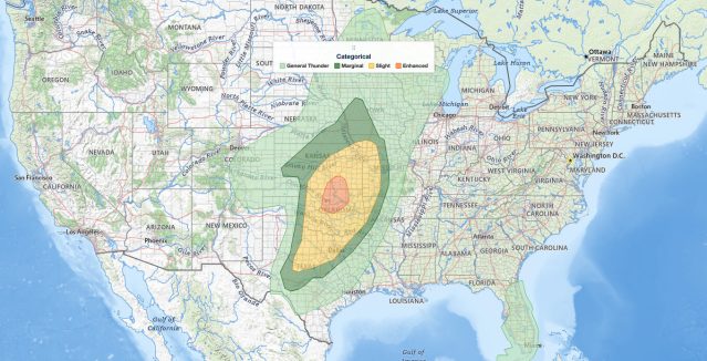
Oklahoma severe thunderstorms are the headline threat on Monday, November 2, 2026, after the NOAA Storm Prediction Center placed north-central Oklahoma and south-central Kansas under an Enhanced Risk, the third of five severe categories (level 3 of 5). Oklahoma City, Tulsa, and Enid sit inside that Enhanced Risk, where the SPC carries a 10% tornado probability, with damaging wind gusts and tornadoes possible from this afternoon into tonight. The outlook was issued 16:06 UTC (11:06 am EST / 10:06 am CST) and runs through 12z (7:00 am EST / 6:00 am CST) Tuesday morning.
Key points:
- Enhanced Risk (level 3 of 5): north-central Oklahoma, south-central Kansas.
- Oklahoma City, Tulsa and Enid carry a 10% SPC tornado probability.
- Damaging wind is the main threat, with a tornado risk this afternoon into tonight.
- Slight Risk reaches Dallas, Fort Worth, Wichita, Topeka and Kansas City.
- 15% large hail probability over Abilene, San Angelo, Wichita Falls and Lawton.
Get Severe Weather Alerts for Your Location
When any NWS watch, warning, or advisory is issued for your area, iAlert sends you an immediate notification by email, text message, or phone call, 24 hours a day, 7 days a week.
Sign Up for Severe Weather Alerts →Where the Oklahoma severe thunderstorms risk is highest
The Enhanced Risk is centered on north-central Oklahoma and south-central Kansas. Oklahoma City, Tulsa, and Enid are the largest population centers inside the Oklahoma severe thunderstorms Enhanced Risk. The SPC summary calls for severe thunderstorms with damaging wind gusts and a tornado risk across parts of the southern and central Plains.
A Slight Risk, the second of five severe categories (level 2 of 5), wraps around that core and includes Wichita, Topeka, and Salina in Kansas; Kansas City, St Joseph, Springfield, and Joplin in Missouri; Fort Smith and Fayetteville in Arkansas; Lawton and Ardmore in Oklahoma; and Dallas, Fort Worth, Wichita Falls, Abilene, and San Angelo in Texas. SPC uses a five-tier system to communicate severe weather potential, laid out in our severe weather outlook explainer.
The outlook reaches farther still, with a Marginal Risk (level 1 of 5) over Omaha, Lincoln, and Council Bluffs, plus Dodge City and Hays in Kansas, Woodward in Oklahoma, and Waco in Texas. Farther east and north, cities such as Little Rock, Shreveport, Columbia, Des Moines, and Grand Island fall in the general thunderstorm area, where storms are expected but are not forecast to be severe.
Hazard probabilities for Oklahoma severe thunderstorms
Damaging wind is the most widespread hazard in the Oklahoma severe thunderstorms forecast. The SPC draws a 15% damaging wind probability over a long corridor that includes Oklahoma City, Tulsa, Wichita, Topeka, Salina, Kansas City, St Joseph, Joplin, Springfield, Fort Smith, Fayetteville, Dallas, Fort Worth, Wichita Falls, Abilene, and San Angelo, among others. A 5% damaging wind probability covers Omaha, Lincoln, Council Bluffs, Dodge City, Hays, and Waco.
An SPC probability is the chance of that hazard being reported within 25 miles of a point, not a wind speed or a hail size. A hatched conditional intensity area for wind covers Oklahoma City, Tulsa, Wichita Falls, Lawton, and Ardmore, marking where storms that do form could reach the higher end of the wind hazard.
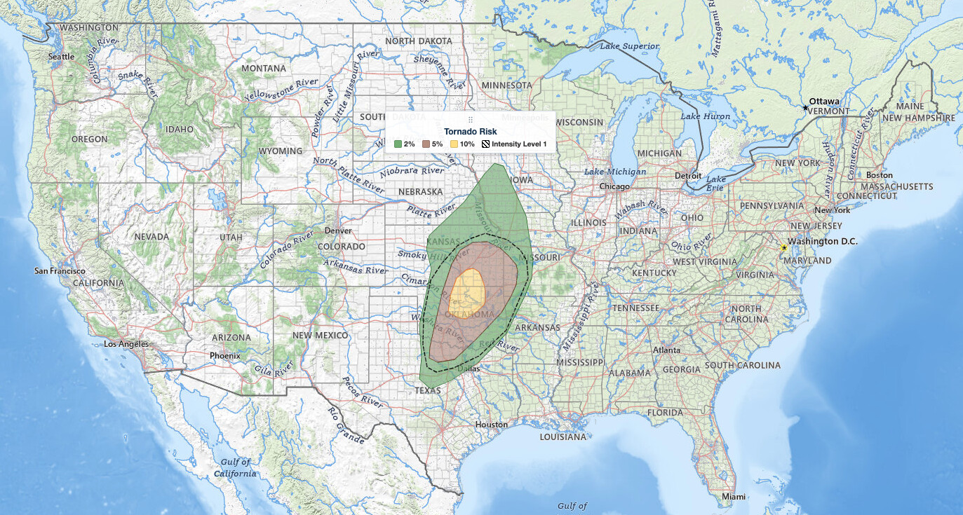
For tornadoes, the 10% probability sits over Oklahoma City, Tulsa, and Enid. A 5% tornado probability covers Wichita, Topeka, Joplin, Wichita Falls, Lawton, and Ardmore, and a 2% probability extends to Dallas, Fort Worth, Kansas City, Springfield, Fort Smith, Fayetteville, Salina, Hays, St Joseph, Abilene, Woodward, Omaha, Lincoln, and Council Bluffs. A hatched conditional intensity area for tornadoes spans a broad swath that includes Oklahoma City, Tulsa, Enid, Wichita, Topeka, Salina, Kansas City, Springfield, Joplin, Fort Smith, and Fayetteville.
Hail is drawn over only 12 of the 26 cities in a severe risk area, far narrower than the wind footprint across the Oklahoma severe thunderstorms risk zone. The 15% large hail probability is anchored in Texas and southwestern Oklahoma at Abilene, Wichita Falls, San Angelo, and Lawton, with 5% at Fort Worth, Oklahoma City, Tulsa, Enid, Wichita, Salina, Woodward, and Ardmore. San Angelo carries hail but no tornado probability, and no tornado probability is drawn at Dodge City or Waco.
Meteorologist’s take
A large upper trough is in place over the western states today, with a strong shortwave trough rotating across the Four Corners area. As that feature and its associated 80 knot plus mid-level jet begin to eject into the southern Plains this afternoon, the SPC expects numerous thunderstorms to form from west-central Texas northward into parts of Kansas and Nebraska.
The ingredient list is broad rather than concentrated: dewpoints in the low to mid 60s, pockets of heating, and strong low-level winds, which together create conditional risks of damaging winds, tornadoes, and some hail. Water vapor imagery shows a lead trough moving into western Oklahoma, and that feature is expected to aid development of scattered thunderstorms by early afternoon, tracking into southern Kansas. Wind fields there are very strong and a few supercell structures are expected, but forecast soundings show poor low-level thermodynamics with LFC heights near 700 mb, which should limit the severe risk with that first round.
The primary severe risk comes with storms forming along the surface dryline over western Oklahoma and south-central Kansas by late afternoon, which is where the SPC focuses the highest Oklahoma severe thunderstorms threat. Shear profiles there favor supercell structures, while cooling temperatures aloft increase the chance of robust updrafts as storms track quickly northeastward. Damaging winds and tornadoes are the main concerns.
By early evening, the Pacific cold front catches up to the convective line, which should produce more linear storm structures and greater wind potential. That line builds southward into west-central Texas through the evening with some risk of damaging winds and a tornado risk, though weaker low-level winds and weaker large-scale dynamics with southward extent lessen the overall severe threat there.
Timing of the Oklahoma severe thunderstorms threat
The window opens by early afternoon Central time, as scattered storms develop over western Oklahoma and track into southern Kansas. The dryline storms that carry the primary risk are expected by late afternoon.
By early evening, the Pacific cold front turns the storms into a more linear line with greater wind potential, and that line builds southward into west-central Texas. Because storms move quickly northeastward, they can cover ground fast, and the threat continues into tonight.
How to stay safe in Oklahoma severe thunderstorms
With a 10% tornado probability over Oklahoma City, Tulsa, and Enid, identify your safe room now: the lowest floor, an interior room away from windows, in a sturdy building. Mobile and manufactured homes are not safe in a tornado warning, so know in advance where you will go and how long it takes to get there.
Damaging wind is the broadest hazard from Oklahoma severe thunderstorms today. The National Weather Service defines a severe gust as 58 mph or greater, which is enough to down tree limbs and power lines, so bring in patio furniture, trash bins, and outdoor decorations, and park vehicles away from large trees. For the Texas and southwestern Oklahoma hail corridor, remember that the National Weather Service defines large hail as at least one inch in diameter, and move vehicles under cover before storms arrive.
Because the Oklahoma severe thunderstorms threat continues after dark, have at least two ways to get warnings that will wake you up. Keep live radar and active alerts handy, and act immediately on a tornado warning rather than waiting to see the storm. Fast-moving storms leave short lead times, so rehearse the plan with everyone in the household before this afternoon.
Oklahoma severe thunderstorms FAQ
Where is the highest risk today?
North-central Oklahoma and south-central Kansas are under the Enhanced Risk, level 3 of 5. Oklahoma City, Tulsa, and Enid sit inside it, with the SPC 10% tornado probability centered there.
Is there a tornado risk?
Yes. Tornadoes are possible with Oklahoma severe thunderstorms this afternoon into tonight. The 10% tornado probability covers Oklahoma City, Tulsa, and Enid, with 5% at Wichita, Topeka, Joplin, Wichita Falls, Lawton, and Ardmore.
How large could the hail get?
The outlook expresses hail as a probability rather than a size, with 15% at Abilene, San Angelo, Wichita Falls, and Lawton. The National Weather Service defines large hail as at least one inch in diameter.
When will storms arrive?
Scattered storms are expected by early afternoon, with the main dryline storms by late afternoon over western Oklahoma and south-central Kansas, and a more linear wind threat by early evening as the Pacific cold front arrives.
Check your local weather forecast and keep alerts enabled through tonight.
Sources:
Get Severe Weather Alerts for Your Location
When any NWS watch, warning, or advisory is issued for your area, iAlert sends you an immediate notification by email, text message, or phone call, 24 hours a day, 7 days a week.
Sign Up for Severe Weather Alerts →