View All Articles

Tropical Storm Karen Named and Targeting U.S. Gulf States

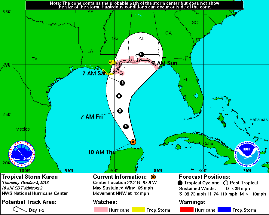
LATEST SUMMARY ON TROPICAL STORM KAREN AS OF SUMMARY OF 1000 AM CDT (11AM ET) LOCATION: LAT/LON: 22.2N & 87.9W ABOUT 65 MI NW CABO CATOCHE MEXICO ABOUT 485 MI  S OF THE MOUTH OF THE MISSISSIPPI RIVER MAXIMUM SUSTAINED WINDS: 65 MPH (100 KM/H) MOVEMENT: NNW OR 330 DEGREES AT 12 MPH (19 KM/)H MINIMUM CENTRAL PRESSURE: 1004 MB (29.65 INCHES) SUMMARY OF WATCHES AND WARNINGS IN EFFECT… A HURRICANE WATCH IS IN EFFECT FOR:
  • GRAND ISLE LOUISIANA TO INDIAN PASS FLORIDA
A TROPICAL STORM WATCH IS IN EFFECT FOR:
  • WEST OF GRAND ISLE TO EAST OF MORGAN CITY LOUISIANA
  • METROPOLITAN NEW ORLEANS
  • LAKE MAUREPAS
  • LAKE PONTCHARTRAIN
A HURRICANE WATCH MEANS THAT HURRICANE CONDITIONS ARE POSSIBLE WITHIN THE WATCH AREA. A WATCH IS TYPICALLY ISSUED 48 HOURS BEFORE THE ANTICIPATED FIRST OCCURRENCE OF TROPICAL-STORM-FORCE WINDS…CONDITIONS THAT MAKE OUTSIDE PREPARATIONS DIFFICULT OR DANGEROUS. A TROPICAL STORM WATCH MEANS THAT TROPICAL STORM CONDITIONS ARE POSSIBLE WITHIN THE WATCH AREA, GENERALLY WITHIN 48 HOURS. FOR STORM INFORMATION SPECIFIC TO YOUR AREA, INCLUDING POSSIBLE INLAND WATCHES AND WARNINGS, ENTER YOUR CITY,STATE OR ZIP CODE TOP RIGHT OF PAGE.  RECEIVE ALERTS DIRECT TO YOUR EMAIL OR MOBILE PHONE BY TEXT MESSAGE BY CLICKING HERE

This entry was posted in Weather Articles and tagged , , , , , , , , , , , . Bookmark the permalink.

Leave a Reply

Read More

Tropical Storm Norbert forecast track on September 13, 2026, showing the 45 mph storm about 1,375 miles east of Hilo, Hawaii, weakening to a remnant low by Tuesday night

Tropical Storm Norbert Forecast: 45 mph Storm Weakens 1,375 Miles East of Hilo, Hawaii

iAlert hurricane tracker satellite view of the Tropical Storm Norbert forecast from the 11 AM HST advisory on Sunday, September 13, 2026, with the Hawaiian Islands highlighted. Green S markers show Norbert at tropical storm strength…

Read More

Tropical Storm Norbert forecast cone on September 12, 2026, tracking west over the East Pacific and weakening east of Hawaii

Tropical Storm Norbert Holds 60 mph Winds Far East of Hawaii, No Coastal Watches in Effect

iAlert hurricane tracker forecast track from the 5 AM HST advisory on Saturday, September 12, 2026. Green S markers show Norbert at tropical storm strength from Saturday through 2 AM Tuesday. Blue D markers show the…

Read More

Upper Midwest severe thunderstorms SPC categorical outlook map for September 11, 2026, showing a Slight Risk over northern and western Minnesota including Duluth, Bemidji, International Falls, and St. Cloud, a Marginal Risk from Minneapolis through eastern South Dakota and Nebraska, and a second Marginal Risk from Memphis and Nashville through Atlanta and the Carolinas to Virginia

Upper Midwest Severe Thunderstorms: Slight Risk of Large Hail, Damaging Wind, and Tornadoes September 11, 2026

Upper Midwest severe thunderstorms are the headline threat on September 11, 2026. The NOAA Storm Prediction Center's Day 1 Convective Outlook, issued at 12:26 UTC (8:26 am EDT / 7:26 am CDT), places Duluth, International Falls,…

Read More

Leave a Reply