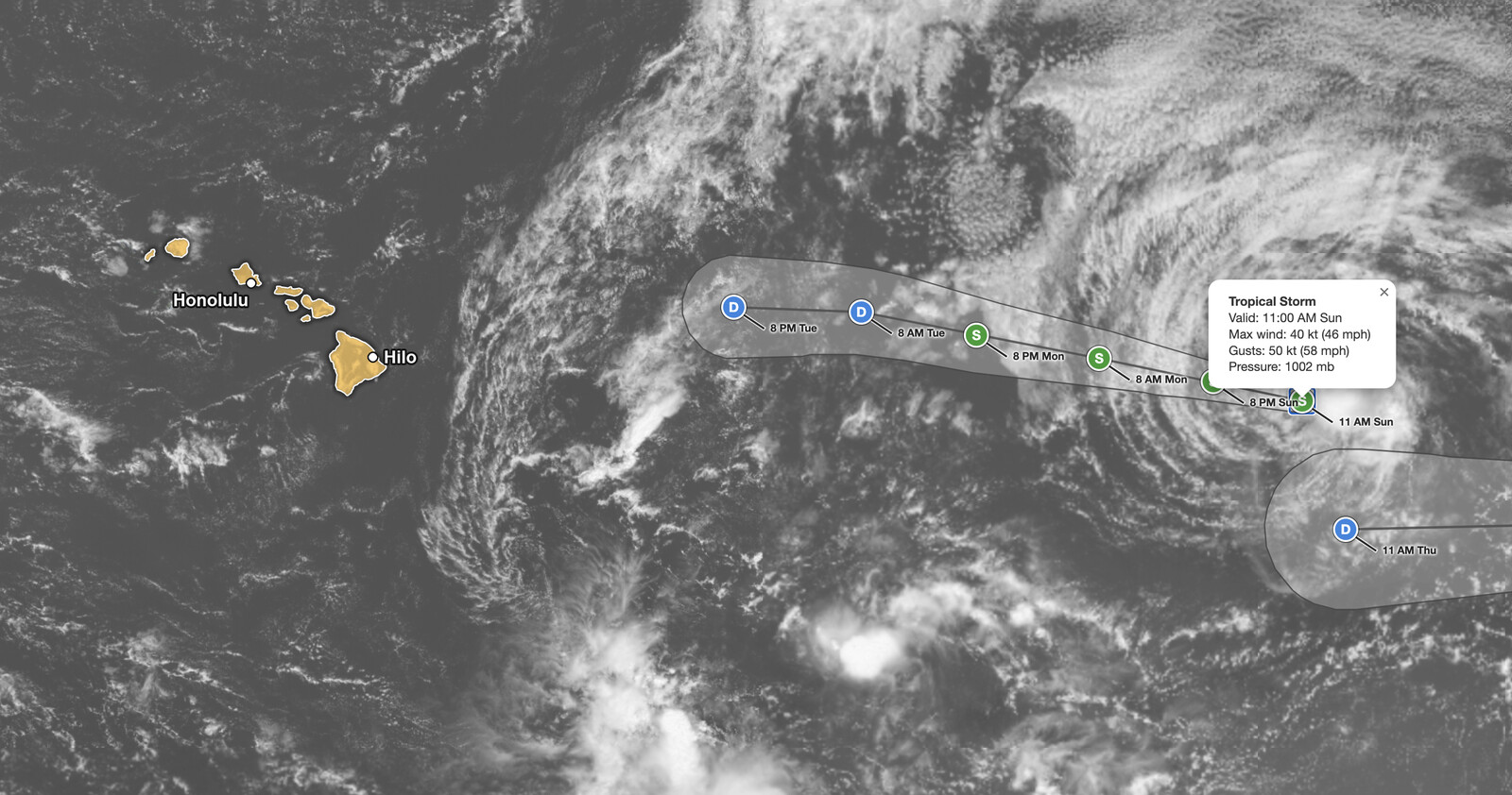
The Tropical Storm Norbert forecast from the National Hurricane Center at 11 AM HST Sunday, September 13, 2026, shows the storm weakening slightly, with maximum sustained winds near 45 mph while centered about 1,375 miles east of Hilo, Hawaii, and about 1,580 miles west of the southern tip of Baja California. There are no coastal watches or warnings in effect, and the advisory lists no hazards affecting land.
Norbert is forecast to drop below tropical storm strength by Tuesday morning, become a post-tropical remnant low by 8 PM HST Tuesday about 535 miles east of Hilo, and dissipate by 8 AM HST Wednesday, September 16.
Key points:
- Maximum sustained winds near 45 mph, gusts to 50 knots (about 58 mph), minimum pressure 1002 mb.
- Center near 18.8N 134.0W, about 1,375 miles east of Hilo, Hawaii, moving west-northwest near 13 mph.
- No coastal watches or warnings, and no hazards affecting land.
- No strengthening forecast: tropical depression by 8 AM HST Tuesday, remnant low by 8 PM HST Tuesday.
- Closest forecast point is about 535 miles east of Hilo, as a remnant low that dissipates by Wednesday.
Get Severe Weather Alerts for Your Location
When any NWS watch, warning, or advisory is issued for your area, iAlert sends you an immediate notification by email, text message, or phone call, 24 hours a day, 7 days a week.
Sign Up for Severe Weather Alerts →Where the Tropical Storm Norbert forecast stands right now
Advisory Number 17, issued at 11 AM HST Sunday (2100 UTC, 2 PM PDT, 5 PM EDT), placed the center of Norbert near latitude 18.8 North, longitude 134.0 West. The storm was moving toward the west-northwest, 290 degrees, near 13 mph. The estimated minimum central pressure was 1002 mb (29.59 inches).
Maximum sustained winds decreased to near 45 mph with higher gusts. The National Hurricane Center says some fluctuations in intensity remain possible for the rest of Sunday, followed by a gradual weakening trend.
Tropical-storm-force winds, 39 mph or greater, extend outward up to 105 miles from the center. The quadrant radii in the Forecast/Advisory show that reach is lopsided: about 105 miles in the northwest quadrant and 90 miles in the northeast, but only about 35 miles southwest and 25 miles southeast.
The Tropical Storm Norbert forecast has trended weaker since Saturday. The 5 AM HST Saturday advisory had Norbert at 60 mph with a forecast peak of 65 mph. Sunday’s advisory has 45 mph with no strengthening, and the remnant low stage now arrives by 8 PM HST Tuesday instead of 2 AM HST Wednesday. Our Saturday Tropical Storm Norbert coverage has the earlier forecast.
What the Tropical Storm Norbert forecast shows through Wednesday
Norbert is expected to move west-northwestward to westward over the next few days as it travels south of a low- to mid-level subtropical ridge. NHC nudged the track slightly north of its previous forecast, and it remains close to the corrected multi-model consensus (HCCA) and the Google DeepMind ensemble mean (GDMI).
The Tropical Storm Norbert forecast track crosses 140 West into the Central Pacific basin between the 8 AM and 8 PM HST forecast points on Monday, September 14. The 8 PM HST Monday point, about 890 miles east of Hilo, is the last one with tropical-storm-force winds, which by then reach only about 45 miles northeast and 35 miles northwest of the center.
The Tropical Storm Norbert forecast points below come from NHC Forecast/Advisory 17. All times are HST, and distances from Hilo are calculated by iAlert.
| Forecast time (HST) | Position | Max winds | Status | Distance from Hilo, Hawaii |
|---|---|---|---|---|
| Sun Sep 13, 11 AM | 18.8N 134.0W | 45 mph | Tropical storm | 1,375 miles east |
| Sun Sep 13, 8 PM | 19.2N 136.0W | 45 mph | Tropical storm | 1,245 miles east |
| Mon Sep 14, 8 AM | 19.7N 138.6W | 40 mph | Tropical storm | 1,070 miles east |
| Mon Sep 14, 8 PM | 20.2N 141.4W | 40 mph | Tropical storm | 890 miles east |
| Tue Sep 15, 8 AM | 20.7N 144.0W | 35 mph | Tropical depression | 720 miles east |
| Tue Sep 15, 8 PM | 20.8N 146.9W | 30 mph | Post-tropical remnant low | 535 miles east |
| Wed Sep 16, 8 AM | Dissipated | |||
By 8 AM HST Tuesday, September 15, Norbert is forecast to be a tropical depression with 35 mph winds, and by 8 PM HST Tuesday a post-tropical remnant low with 30 mph winds. That 8 PM Tuesday point is the closest forecast approach, about 535 miles east of Hilo. Dissipation is forecast by 8 AM HST Wednesday, September 16.
NHC also began advisories Sunday on a separate system, Tropical Depression Fifteen-E, far to the east near 17.2N 117.2W. Its first forecast takes it to a remnant low near 16.0N 133.0W by Thursday, September 17, which is the partial cone at the lower right of the image above.
Meteorologist’s take
Satellite imagery explains Sunday’s downgrade. NHC noted that Norbert’s center had become exposed on visible imagery, with the bulk of the thunderstorms on the south and east sides of the storm, and water vapor imagery showed a good amount of dry air penetrating the core. An exposed center is the signature of a cyclone losing its vertical structure.
The intensity estimates did not line up neatly. The TAFB Dvorak estimate (a method that reads storm strength from satellite cloud patterns) came in near 45 knots, about 52 mph. The UW-CIMSS objective estimates ranged from 32 to 39 knots, about 37 to 45 mph, and an ASCAT scatterometer pass (a satellite instrument that measures wind at the ocean surface) found the strongest winds near the center around 37 knots, about 43 mph. Weighing those, NHC lowered the initial intensity to 40 knots, or 45 mph.
NHC describes a marginal environment. Norbert continues to contend with mid-level dry air intrusions and light west-southwesterly vertical wind shear, and after 12 hours that shear is expected to increase, which should result in gradual weakening. Around 60 hours, 8 PM HST Tuesday, simulated GFS and ECMWF satellite imagery shows the cyclone losing organized deep convection. That is why the Tropical Storm Norbert forecast calls for a post-tropical remnant low at that time and dissipation by around 72 hours.
For reference, a post-tropical remnant low no longer has the organized thunderstorm activity required of a tropical cyclone, and its maximum sustained winds are below 39 mph. A tropical depression has sustained winds of 38 mph or less, a tropical storm 39 to 73 mph, and a hurricane 74 mph or more.
The takeaway: track guidance continues to show good agreement on Norbert’s general heading, and the NHC intensity forecast sits in line with the HCCA and GDMI consensus. With both pointing to a weakening storm moving into shear and dry air, this is a marine story, not a Hawaii story. The forecast cone shows the probable track of the center, not the size of the storm or the reach of its impacts.
Who needs to act on the Tropical Storm Norbert forecast
There are no coastal watches or warnings in effect. A tropical storm or hurricane watch means those conditions are possible within 48 hours, and a warning means they are expected within 36 hours. The last forecast point with tropical-storm-force winds sits about 890 miles east of Hilo, Hawaii.
Mariners are the only group with an active concern in the Tropical Storm Norbert forecast. Seas of 4 meters (13 feet) or higher extend up to about 105 miles northeast of the center, 85 miles northwest, and 35 miles in the southeast and southwest quadrants. NHC has requested 3-hourly ship reports from vessels within 300 miles of the center, and crews in that area should follow NWS high seas forecasts and report conditions.
For residents of Hawaii, the Tropical Storm Norbert forecast calls for monitoring, not preparation. NHC lists no land hazards, and the system is forecast to be a remnant low at its closest point. Follow Norbert and Tropical Depression Fifteen-E on the iAlert hurricane tracker as new advisories arrive every six hours.
The Central Pacific hurricane season runs through November 30. Keep a way to receive warnings that does not depend on Wi-Fi or home power, and review your plan each time a storm enters the basin.
Tropical Storm Norbert forecast FAQ
Is Tropical Storm Norbert a danger to Hawaii?
No. The National Hurricane Center lists no hazards affecting land and no coastal watches or warnings. The closest forecast approach is about 535 miles east of Hilo, Hawaii, at 8 PM HST Tuesday, September 15, when Norbert is expected to be a post-tropical remnant low.
How strong is Tropical Storm Norbert?
Maximum sustained winds are near 45 mph with higher gusts as of 11 AM HST Sunday, September 13, and the minimum central pressure is 1002 mb. The Tropical Storm Norbert forecast shows no strengthening from here.
Where is Norbert headed?
Storm Norbert forecast shows no strengthening from here.Where is Norbert headed?
Norbert is moving west-northwest near 13 mph and is expected to continue west-northwestward to westward for the next few days, south of a low- to mid-level subtropical ridge. The track crosses into the Central Pacific basin Monday, September 14.
When will Norbert dissipate?
Gradual weakening is expected after about 12 hours as vertical wind shear increases. NHC forecasts a tropical depression by 8 AM HST Tuesday, a post-tropical remnant low by 8 PM HST Tuesday, and dissipation by 8 AM HST Wednesday, September 16.
Sources:
- NHC Tropical Storm Norbert Public Advisory Number 17
- NHC Tropical Storm Norbert Forecast Discussion Number 17
- NHC Tropical Storm Norbert Forecast/Advisory Number 17
- NHC Tropical Storm Norbert Forecast Discussion Number 12 (Saturday comparison)
- NHC Tropical Depression Fifteen-E Forecast Discussion Number 1
- NHC Tropical Storm Norbert advisory archive (all products)
Get Severe Weather Alerts for Your Location
When any NWS watch, warning, or advisory is issued for your area, iAlert sends you an immediate notification by email, text message, or phone call, 24 hours a day, 7 days a week.
Sign Up for Severe Weather Alerts →