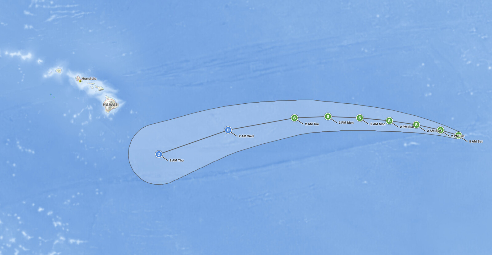
Tropical Storm Norbert was centered about 1,255 miles west-southwest of the southern tip of Baja California and about 1,760 miles east of Hilo, Hawaii, at 5:00 a.m. HST on Saturday, September 12, 2026, with maximum sustained winds near 60 mph. The National Hurricane Center lists no coastal watches or warnings and no hazards affecting land. Norbert is moving west-northwest at 10 mph over open water, and the official forecast weakens it to a post-tropical remnant low by early Wednesday.
Key points:
- Maximum sustained winds near 60 mph with higher gusts; minimum central pressure 999 mb.
- Center near 17.3N 128.3W, moving west-northwest at 10 mph.
- No coastal watches or warnings and no hazards affecting land.
- Forecast peak of 65 mph through early Sunday, then gradual weakening early next week.
- Post-tropical remnant low forecast by 2 a.m. HST Wednesday, September 16, about 590 miles east-southeast of Hilo.
Get Severe Weather Alerts for Your Location
When any NWS watch, warning, or advisory is issued for your area, iAlert sends you an immediate notification by email, text message, or phone call, 24 hours a day, 7 days a week.
Sign Up for Severe Weather Alerts →Where Tropical Storm Norbert stands now
Advisory Number 12 from the National Hurricane Center in Miami placed the center near latitude 17.3 North, longitude 128.3 West at 1500 UTC Saturday. That is 5:00 a.m. HST, 8:00 a.m. PDT, and 11:00 a.m. EDT.
Maximum sustained winds are 60 mph (50 knots) with higher gusts, and the minimum central pressure is 999 mb. That leaves Tropical Storm Norbert 14 mph below the 74 mph hurricane threshold. The NHC discussion notes the objective and subjective intensity estimates were unchanged from six hours earlier.
The wind field of Tropical Storm Norbert is lopsided. Tropical-storm-force winds reach up to 105 miles from the center to the northwest and about 90 miles to the northeast, but only about 30 miles to the south. NHC expanded the northern wind radii after an OSCAT-3 scatterometer pass (a satellite instrument that measures winds at the ocean surface) at 0842 UTC.
The most important line in the advisory for readers on land is the shortest one. Under “Hazards Affecting Land,” the National Hurricane Center listed a single word: none.
Forecast track and intensity for Tropical Storm Norbert
Forecasters expect a turn toward the west on Sunday, with that general heading continuing for the next several days as a subtropical ridge to the north steers the storm. Most of the skilled track models shifted north on this cycle, so NHC moved its official track to the right of the previous forecast, close to the GDMI ensemble mean and the HCCA consensus aid.
Only modest strengthening is expected through the weekend, with a forecast peak of 65 mph. Gradual weakening follows early next week. The forecast table shows Tropical Storm Norbert crossing 140°W into the Central Pacific basin between 2 p.m. HST Monday and 2 a.m. HST Tuesday, then becoming a post-tropical remnant low by 2 a.m. HST Wednesday, September 16.
| Forecast time (HST) | Position | Max winds | Status |
|---|---|---|---|
| Sat Sep 12, 5 AM | 17.3N 128.3W | 60 mph | Tropical storm |
| Sat Sep 12, 2 PM | 17.7N 129.7W | 65 mph | Tropical storm |
| Sun Sep 13, 2 AM | 18.1N 131.6W | 65 mph | Tropical storm |
| Sun Sep 13, 2 PM | 18.4N 133.7W | 60 mph | Tropical storm |
| Mon Sep 14, 2 AM | 18.6N 136.0W | 50 mph | Tropical storm |
| Mon Sep 14, 2 PM | 18.7N 138.5W | 45 mph | Tropical storm |
| Tue Sep 15, 2 AM | 18.6N 141.1W | 40 mph | Tropical storm |
| Wed Sep 16, 2 AM | 17.7N 146.3W | 35 mph | Post-tropical remnant low |
| Thu Sep 17, 2 AM | 15.9N 151.7W | 30 mph | Post-tropical remnant low |
Uncertainty grows with time. NHC says its track errors have averaged near 100 nautical miles (about 115 miles) on day 4 and 125 nautical miles (about 145 miles) on day 5, with intensity errors near 15 knots (about 17 mph) each day.
No watches or warnings are in effect because tropical-storm-force winds are not forecast to reach any land during the five-day forecast. A tropical storm watch means tropical storm conditions are possible within 48 hours, and a warning means they are expected within 36 hours. The last forecast point with tropical-storm-force winds, 2 a.m. HST Tuesday, is about 915 miles east of Hilo.
Meteorologist’s take
The NHC discussion is plain about why Norbert has not strengthened much. The storm sits over warm ocean water, but marginal moisture in the low to mid levels and southerly vertical wind shear (winds changing speed or direction with height, which tilts a storm and tears at its thunderstorms) have held it in check. Only two guidance aids, the HFIP HCCA consensus and Google DeepMind WeatherNext 2 (GDMI), show any short-term strengthening.
On satellite, NHC describes Norbert as “an amorphous blob of deep convection” bursting on and off, and a microwave pass placed the surface center near the southern edge of that thunderstorm mass. A center sitting on the upwind edge of its convection is the classic signature of shear, and it matches the reasoning in the discussion.
The northward model shift is the bigger story. It places Norbert’s future path in increasingly unfavorable environmental conditions, which is why NHC lowered its intensity forecast beyond 24 hours.
A post-tropical remnant low is a circulation that no longer has the organized thunderstorm activity required of a tropical cyclone, with sustained winds below 39 mph. Remnant lows can drift for days, but NHC no longer classifies them as tropical cyclones.
For Hawaii, the useful reference point is the day 5 position: a 30 mph remnant low about 345 miles southeast of Hilo, at a range where NHC’s average track error is about 145 miles. The islands had a Hurricane Warning for Kauai County from Hurricane Lowell less than a week ago, so the attention is understandable. Tropical Storm Norbert is a different setup: a weakening storm steered west by a ridge to its north, with no forecast turn toward the islands.
How to stay safe while Tropical Storm Norbert is over open water
With no hazards affecting land, no protective action is needed on any coastline right now. For Hawaii residents, the right response is watching each new advisory, not preparation.
Mariners have a real reason to pay attention. The NHC forecast advisory shows seas of 4 meters (13 feet) extending up to 150 nautical miles (about 175 miles) from the center in the northeast and northwest quadrants, and NHC requested 3-hourly ship reports within 300 miles of the storm. Vessels crossing this part of the Pacific should route well clear of the northern half of the circulation.
You can follow Tropical Storm Norbert on the iAlert hurricane tracker and check active weather alerts and your local weather forecast as each advisory publishes. Complete advisories arrive at 5:00 and 11:00, a.m. and p.m. HST. The next one is due at 11:00 a.m. HST Saturday.
For now, Tropical Storm Norbert is a mid-ocean system with 60 mph winds, no coastal watches or warnings, and a forecast that weakens it to a remnant low by early Wednesday. Treat it as a tracking item, not a threat.
Tropical Storm Norbert FAQ
Is Tropical Storm Norbert a threat to Hawaii?
Not in the current forecast. No watches or warnings are in effect, and NHC lists no hazards affecting land. The center was about 1,760 miles east of Hilo at 5:00 a.m. HST Saturday, and the final forecast point is a 30 mph remnant low about 345 miles southeast of Hilo early Thursday.
How strong is Tropical Storm Norbert?
Maximum sustained winds are near 60 mph with higher gusts, and the minimum central pressure is 999 mb. NHC forecasts a peak of 65 mph through early Sunday.
Where is Tropical Storm Norbert headed?
Norbert is moving west-northwest at 10 mph, and a turn toward the west is forecast on Sunday. It is forecast to cross 140°W into the Central Pacific basin late Monday or early Tuesday, HST.
When will Tropical Storm Norbert weaken?
Gradual weakening is expected to begin early next week. The NHC forecast table shows Norbert as a post-tropical remnant low by 2 a.m. HST Wednesday, September 16.
Sources:
- NWS National Hurricane Center, Tropical Storm Norbert
Sources:
- NWS National Hurricane Center, Tropical Storm Norbert Public Advisory Number 12, 5:00 AM HST September 12, 2026
- NWS National Hurricane Center, Tropical Storm Norbert Forecast Discussion Number 12, 5:00 AM HST September 12, 2026
- NWS National Hurricane Center, Tropical Storm Norbert Forecast/Advisory Number 12, 1500 UTC September 12, 2026
- NWS National Hurricane Center, Tropical Storm Norbert advisory archive
Get Severe Weather Alerts for Your Location
When any NWS watch, warning, or advisory is issued for your area, iAlert sends you an immediate notification by email, text message, or phone call, 24 hours a day, 7 days a week.
Sign Up for Severe Weather Alerts →