 Hail
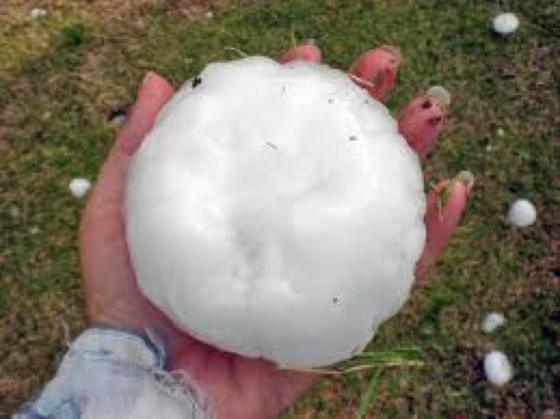
Hail, Showery precipitation in the form of irregular pellets or balls of ice more than 5 mm in diameter, falling from a cumulonimbus cloud.
Ok great with the definition out of the way we can breakdown this amazing weather phenomenon for a much deeper understanding of hail.
How does hail form?
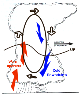
- Inside of a thunderstorm are strong updrafts of warm air and downdrafts of cold air.
- If a water droplet is picked up by the updrafts it can be carried well above the freezing level. With temperatures below 32F the water droplet freezes.
- As the frozen droplet begins to fall, carried by cold downdrafts, it may thaw as it moves into warmer air toward the bottom of the thunderstorm
- The small half-frozen droplet may then again get picked up by another updraft carrying it back into freezing temperatures. With each trip above and below the freezing level our frozen droplet adds another layer of ice and so gets larger.
- Finally the frozen water droplet, with many layers of ice much like the rings in a tree, falls to the ground as hail.
How large can hail get?
- Most hail is usually less than 2 inches in diameter.
- The largest hailstone fell on June 23, 2003 in Aurora, Nebraska and had a diameter of? 7.0 inches, a circumference of 18.75 inches, and weighed just under 1 lb.
- The heaviest hailstone fell in Coffeeville, Kansas on September3, 1970 and weighed 1.67 lbs.? It had a diameter of 5.7 inches and a circumference of 17.5 inches.
Estimating hail size:
- Pea = 1/4 inch diameter
- Marble/mothball = 1/2 inch diameter
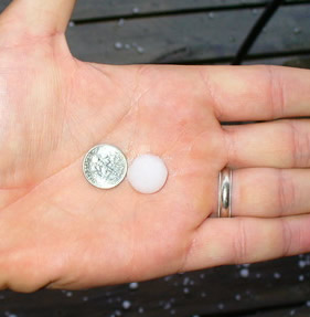
- Dime/Penny = 3/4 inch hail. This size and larger is considered severe
- Nickel = 7/8 inch diameter
- Quarter = 1 inch diameter
- Ping-Pong Ball = 1 1/2 inch diameter
- Golf Ball = 1 3/4 inch diameter
- Tennis Ball 2 1/2 inch diameter
- Baseball = 2 3/4 inch diameter
- Tea Cup = 3 inch diameter
- Grapefruit = 4 inch diameter
- Softball = 4 1/2 inch diameter
?Additional Information About Hail:
- The presence of hail indicates strong updrafts and downdrafts within the thunderstorm.? This is also an indicator of tornadic activity
- Often large hail is observed immediately north of a tornado track, however the presence of hail does not always mean a tornado and the absence of hail does not always mean there is not a risk of tornadoes
- There is no positive way to look at a thunderstorm in the distance and tell if it will produce hail
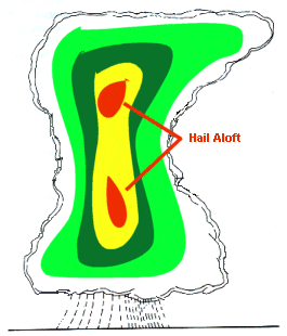
- Meteorologists use weather radar to “look” inside a thunderstorm.? This is possible since hail reflects more energy back to the radar than raindrops and so shows up red or purple as shown in the image below.
- The WSR-88D Doppler Radar can also estimate size of the hail based on the amount of energy reflected back.
Related Articles: