
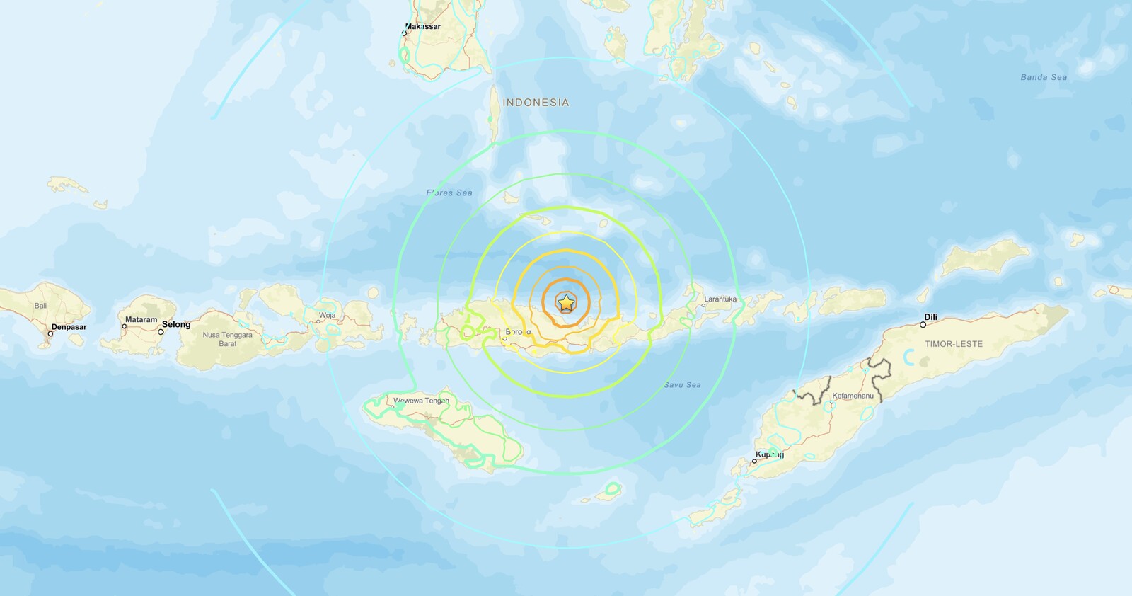
Indonesia earthquake activity produced a magnitude 7.7 event near Ende, in East Nusa Tenggara, on Saturday, August 15, 2026, exposing approximately 1.5 million people to strong (MMI VI) to severe (MMI VIII) shaking. The USGS assessed that some casualties and damage are possible, with impacts expected to be relatively localized.
Key points:
- Magnitude 7.7 struck near Ende, East Nusa Tenggara, Indonesia on August 15, 2026 local time.
- About 1.5 million people exposed to strong (MMI VI) to severe (MMI VIII) shaking.
- USGS assessed casualties and damage are possible but likely localized.
- The earthquake resulted from shallow reverse (thrust) faulting in the Flores Sea.
- Aftershocks, potentially with strong shaking, may follow.
What Happened in the Indonesia Earthquake Near Ende
The USGS located the Indonesia earthquake off the northern coast of East Nusa Tenggara, in the Flores Sea. It resulted from reverse faulting at shallow depth, with focal mechanism solutions pointing to either a west-striking fault dipping moderately to the north or an east-striking fault dipping shallowly to the south. Based on location, depth, and the preliminary focal mechanism, the USGS indicated the event is likely the result of thrust faulting within the overriding Sunda plate.
Earthquakes of this magnitude are not accurately represented as a single point. A reverse-faulting event of this size typically involves a fault rupture area on the order of 90 by 45 kilometers. That scale of rupture means shaking affects a broad geographic footprint, which is consistent with the 1.5 million people who experienced significant ground motion in this Indonesia earthquake.
The USGS updated its assessment at 07:22 a.m. local time on August 15 (23:22 UTC on August 14), noting that strong aftershocks are possible. Residents in the affected area should expect additional shaking in the hours and days following the main event.
Tectonic Setting: Why the Flores Sea Sees Indonesia Earthquake Activity
The region where this Indonesia earthquake occurred sits at the convergence boundary between the Australian plate and the Sunda plate. The Australian plate moves northward relative to the Sunda plate at approximately 69 millimeters per year. These plates meet at the Sunda Trench, located roughly 350 kilometers south of the August 15 event.
This convergence zone is one of the most seismically active in the world. Since 1950, the USGS recorded 37 other earthquakes of magnitude 6.0 or greater within 250 kilometers of Saturday’s epicenter, including five events of magnitude 7.0 or larger. The most relevant historical precedent is a M7.8 earthquake in 1992, centered just 63 kilometers east-southeast of the August 15 event. That earthquake and the tsunami it generated destroyed tens of thousands of homes and caused at least 2,500 fatalities.
The 1992 event is a sobering benchmark. It demonstrates that shallow thrust earthquakes in this part of Indonesia can produce both severe ground shaking and dangerous tsunamis, depending on the fault geometry and the direction of seafloor displacement.
Meteorologist’s Take
While earthquakes fall outside the meteorological discipline, the broader geophysical hazard environment in this part of Indonesia requires that emergency managers and residents treat every major shallow thrust event as a potential tsunami source until authorities confirm otherwise. The Indonesia earthquake on August 15 occurred offshore in the Flores Sea, a setting where seafloor deformation can displace the water column rapidly.
The MMI scale that USGS uses to characterize shaking intensity matters for understanding structural risk. MMI VIII, described as severe, is associated with considerable damage in ordinary buildings, partial collapses in poorly built structures, and heavy damage to unreinforced masonry. With 1.5 million people inside that shaking footprint, the localized damage assessment from USGS still implies a meaningful number of structures at risk, particularly in rural areas of East Nusa Tenggara where construction standards vary widely.
Aftershock sequences following M7.7 events can include shocks in the mid-6 range for days to weeks. Buildings already weakened by the main shock are more vulnerable to aftershock damage, which is why early structural inspection matters before re-occupancy.
How to Stay Safe During an Indonesia Earthquake Event and Its Aftershocks
If you are in the affected region of East Nusa Tenggara and experienced this Indonesia earthquake, the most immediate priority is to move away from coastlines until tsunami authorities issue an all-clear. Shallow offshore thrust earthquakes can generate local tsunamis with very short travel times, sometimes less than 10 minutes to the nearest shore.
can generate local tsunamis with very short travel times, sometimes less than 10 minutes to the nearest shore.During aftershocks, drop to the ground, take cover under a sturdy table or desk, and hold on until shaking stops. Avoid re-entering damaged buildings before they are inspected. If you are outdoors, move away from unstable walls, downed power lines, and slopes that could be destabilized by continued shaking.
Stay informed through official channels. You can monitor active alerts and get local forecasts through iAlert’s active weather alerts page, and check the USGS Did You Feel It? survey to contribute your shaking report, which helps scientists refine hazard assessments in real time.
Indonesia Earthquake FAQ
How strong was the Indonesia earthquake near Ende?
The earthquake measured magnitude 7.7, making it a major earthquake. It exposed approximately 1.5 million people to strong to severe shaking, reaching MMI VIII in parts of the affected area.
Was a tsunami generated by this Indonesia earthquake?
The USGS source summary does not confirm a tsunami was generated. However, shallow offshore thrust earthquakes in this region carry tsunami potential, and residents near the coast should follow guidance from local and national authorities until an official all-clear is issued.
Are aftershocks expected following this Indonesia earthquake?
Yes. The USGS specifically noted that aftershocks, some potentially with strong shaking, may follow the M7.7 main shock. Aftershock sequences for events of this size can continue for days to weeks.
Has this part of Indonesia experienced major earthquakes before?
Yes. Since 1950, 37 earthquakes of M6.0 or greater have occurred within 250 kilometers of Saturday’s epicenter. A M7.8 in 1992, just 63 kilometers away, caused at least 2,500 fatalities and destroyed tens of thousands of homes.
Sources:
Get Severe Weather Alerts for Your Location
When any NWS watch, warning, or advisory is issued for your area, iAlert sends you an immediate notification by email, text message, or phone call, 24 hours a day, 7 days a week.
Sign Up for Severe Weather Alerts →

