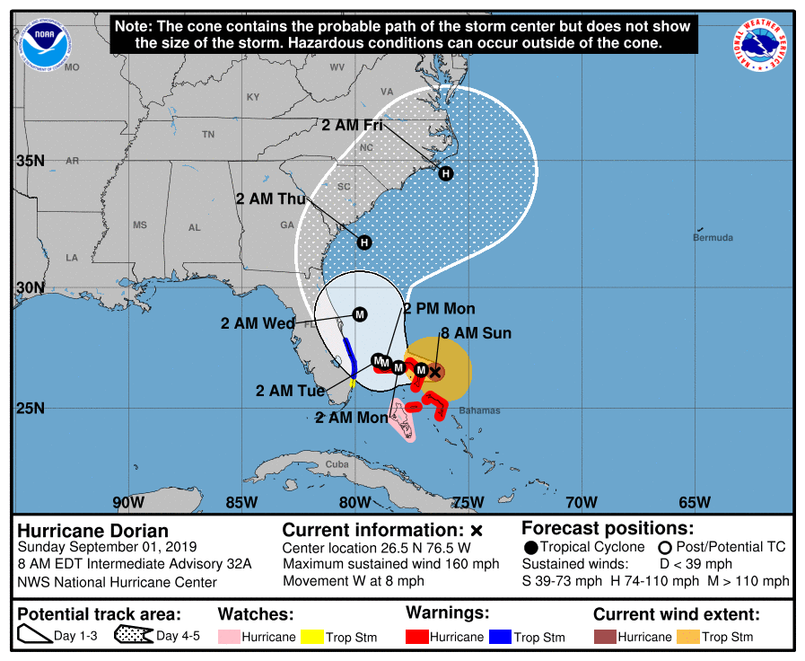
…EYEWALL OF NOW CATASTROPHIC CATEGORY 5 HURRICANE DORIAN ABOUT TO HIT THE ABACO ISLANDS WITH DEVASTATING WINDS…
…LIFE-THREATENING STORM SURGE AND VERY HEAVY RAINFALL ALSO
EXPECTED…
SUMMARY OF 800 AM EDT…1200 UTC…INFORMATION
———————————————-
LOCATION…26.5N 76.5W
ABOUT 35 MI…55 KM E OF GREAT ABACO ISLAND
ABOUT 225 MI…360 KM E OF WEST PALM BEACH FLORIDA
MAXIMUM SUSTAINED WINDS…160 MPH…260 KM/H
PRESENT MOVEMENT…W OR 275 DEGREES AT 8 MPH…13 KM/H
MINIMUM CENTRAL PRESSURE…927 MB…27.37 INCHES
WATCHES AND WARNINGS
——————–
CHANGES WITH THIS ADVISORY:
None.
SUMMARY OF WATCHES AND WARNINGS IN EFFECT:
A Hurricane Warning is in effect for…
* Northwestern Bahamas excluding Andros Island
A Hurricane Watch is in effect for…
* Andros Island
A Tropical Storm Warning is in effect for…
* North of Deerfield Beach to Sebastian Inlet
A Tropical Storm Watch is in effect for…
* North of Golden Beach to Deerfield Beach
A Hurricane Warning means that hurricane conditions are expected
somewhere within the warning area. Preparations to protect life and
property should be rushed to completion.
A Hurricane Watch means that hurricane conditions are possible
within the watch area.
A Tropical Storm Warning means that tropical storm conditions are
expected within the warning area within 36 hours.
A Tropical Storm Watch means that tropical storm conditions are
possible within the watch area, generally within 48 hours.
Interests elsewhere in southern and central Florida should continue
to monitor the progress of Dorian. Additional watches or warnings
may be required for portions of the east coast of Florida today.
For storm information specific to your area in the United States,
including possible inland watches and warnings, please monitor
products issued by your local National Weather Service forecast
office. For storm information specific to your area outside of the
United States, please monitor products issued by your national
meteorological service.
DISCUSSION AND OUTLOOK
———————-
At 800 AM EDT (1200 UTC), the distinct eye of Hurricane Dorian
was located near latitude 26.5 North, longitude 76.5 West. Dorian
is moving toward the west near 8 mph (13 km/h), and a slower
westward motion should occur for the next day or two, followed by a
gradual turn toward the northwest. On this track, the core of
extremely dangerous Hurricane Dorian should be moving over Great
Abaco soon, and continue near or over Grand Bahama Island later
tonight and Monday. The hurricane should move closer to the Florida
east coast late Monday through Tuesday night.
Data from an Air Force Hurricane Hunter plane which just penetrated
the eye of Dorian indicate that the maximum sustained winds have
increased to near 160 mph (260 km/h) with higher gusts. Dorian is
now a category 5 hurricane on the Saffir-Simpson Hurricane Wind
Scale. Some fluctuations in intensity are likely, but Dorian is
expected to remain a powerful hurricane during the next few days.
Hurricane-force winds extend outward up to 30 miles (45 km) from
the center, and tropical-storm-force winds extend outward up to 105
miles (165 km). Elbow Cay in the Abaco Islands just reported winds
of 35 mph (56 km/h)
The minimum central pressure just measured by an Air Force plane was
927 mb (27.37 inches).
HAZARDS AFFECTING LAND
———————-
WIND: Devastating hurricane conditions are expected in the Abacos
Islands very soon and these conditions will spread across Grand
Bahama Island later today.
Tropical storm conditions are expected within the tropical storm
warning area on Monday.
Tropical storm conditions are possible within the tropical storm
watch area by Monday night.
STORM SURGE: A life-threatening storm surge will raise water levels
by as much as 15 to 20 feet above normal tide levels in areas of
onshore winds on the Abaco Islands and Grand Bahama Island. Near
the coast, the surge will be accompanied by large and destructive
waves.
RAINFALL: Dorian is expected to produce the following rainfall
totals through late this week:
Northwestern Bahamas…12 to 24 inches, isolated 30 inches.
Coastal Carolinas…5 to 10 inches, isolated 15 inches.
Central Bahamas and the Atlantic Coast from the Florida peninsula
through Georgia…2 to 4 inches, isolated 6 inches.
This rainfall may cause life-threatening flash floods.
SURF: Large swells will affect the east-facing shores of the
Bahamas, the Florida east coast, and the southeastern United States
coast during the next few days. These swells are likely to cause
life-threatening surf and rip current conditions. Please consult
products from your local weather office.
Related Articles:



