Tropical Storm Erin Named
Tropical depression becomes tropical storm Erin west-southwest of southern Cape Verde Islands. As of 8:00am AST (7:00 am EST) the center of Tropical Storm Erin was located near latitude 14.5 north and longitude 25.6 west. Erin is moving west-northwest at about 16 mph and will continue this direction while decreasing forward speed over the next couple days.
Maximum sustained winds have increased to near 40 mph with higher gusts. Some additional strengthening is forecast during the next couple days. Tropical storm force winds extend from the center of Erin out 35 miles. Estimated minimum central pressure is 1006 MB or 29.71 inches.
Tropical storm conditions are expected over southern Cape Verde Islands during the next few hours. Stronger winds are likely in areas of higher terrain on the islands. Expected rainfall accumulations of 2 to 4 inches are expected with Tropical Storm Erin over the southern portion of the Cape Verde Islands
This entry was posted in Weather Articles and tagged Cape Verde Islands, Erin, rainfall, Tropical, tropical depression, tropical storm, tropical storm conditions, tropical storm Erin, wind. Bookmark the permalink.
Read More
Critical Fire Weather Outlook: SPC Flags Dangerous Conditions June 30 Through July 2, 2026
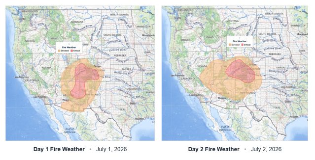
Critical fire weather conditions are in place across portions of the United States from June 30 through July 2, 2026, according to a series of Day 1 and Day 2 Fire Weather Outlooks issued by the…
Midwest Severe Thunderstorms: Enhanced Risk Brings 80 MPH Gusts, Large Hail, and Tornadoes on July 1
Midwest severe thunderstorms are forecast to bring dangerous weather across the Upper Midwest and Great Lakes region on Wednesday, July 1, 2026. The NOAA Storm Prediction Center has issued an Enhanced Risk, the third of five…
Severe Thunderstorms Wisconsin Michigan and Northeast: SPC Slight Risk for June 30, 2026
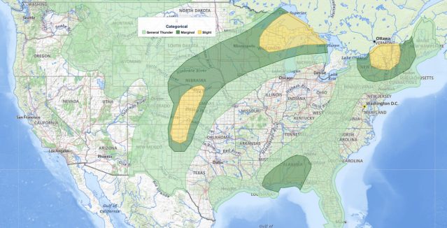
Severe thunderstorms Wisconsin Michigan and the Upper Peninsula face a Slight Risk on June 30, 2026, the second of five severe categories (level 2 of 5) in the NOAA Storm Prediction Center's Day 1 Convective Outlook.…


