Critical fire weather conditions are in place across portions of the United States from June 30 through July 2, 2026, according to a series of Day 1 and Day 2 Fire Weather Outlooks issued by the NOAA Storm Prediction Center. The SPC has flagged its second-highest risk tier, Critical, on each outlook day, signaling a dangerous combination of strong winds, low relative humidity, and dry fuels capable of rapidly spreading any ignition.
Key points:
- SPC issued Critical fire weather outlooks for June 30, July 1, and July 2, 2026.
- Critical is the second-highest of three SPC fire weather risk tiers.
- Both Elevated and Critical risk zones are present across all three outlook days.
- Hazards include strong wind, low humidity, and dry fuel conditions.
- These outlooks flag dangerous weather, not confirmed active fires.
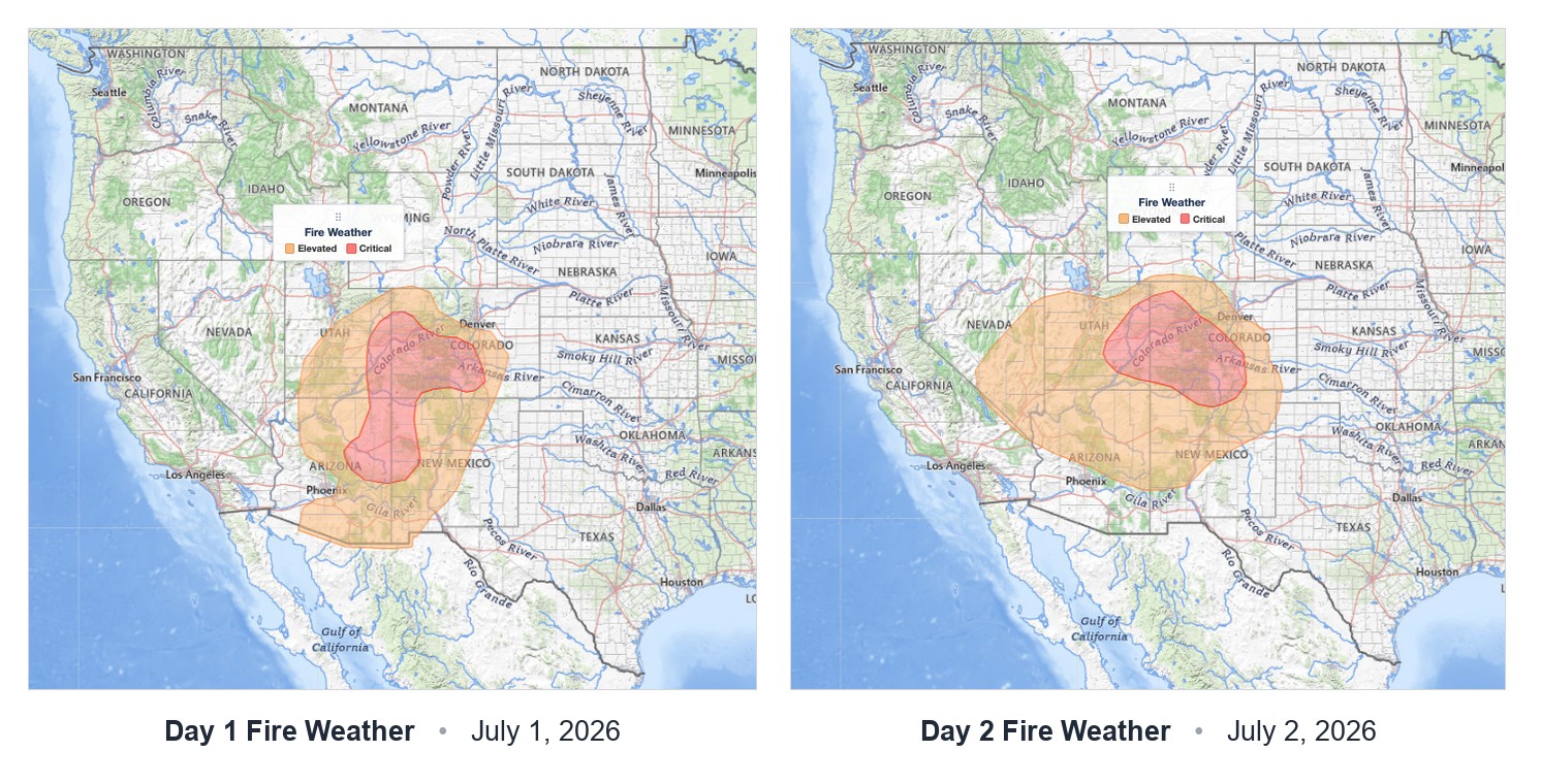
What the SPC Fire Weather Outlooks Show
The Storm Prediction Center released a Day 1 Fire Weather Outlook valid for June 30, 2026, followed by an updated Day 1 outlook valid for July 1, 2026, and a Day 2 outlook valid for July 2, 2026. Each product carries the Critical risk designation at its highest level, with Elevated risk also present in surrounding areas. The SPC emphasizes that these outlooks describe atmospheric conditions favorable for wildfire spread, not reports of ongoing fires.
The three-day stretch of consecutive Critical outlooks is significant. When the SPC issues back-to-back Critical designations spanning multiple calendar days, it reflects a persistent pattern of hazardous fire weather rather than a brief, isolated episode. Forecasters and fire managers treat multi-day Critical streaks as a signal to pre-position suppression resources and escalate public messaging.
Understanding the Critical Fire Weather Risk Tier
The SPC uses a three-tier fire weather risk scale: Elevated, Critical, and Extreme. A Critical designation, the middle tier, requires a forecast combination of strong surface winds, very low relative humidity, and receptive, dry fuels. Even a small ignition source under these conditions can produce a fast-moving fire that outpaces initial suppression efforts. You can review how the SPC defines each risk category on the SPC outlook risk categories explained page at iAlert.
Low humidity is often the most underappreciated ingredient. When relative humidity drops below roughly 15 percent, live and dead vegetation loses moisture rapidly, lowering the energy needed to sustain combustion. Combine that with sustained winds above 20 mph and gusts that can exceed 35 mph, and fires can crown, spot ahead of the main flame front, and resist aerial attack.
Meteorologist’s Take
Three consecutive days of SPC Critical fire weather outlooks, spanning June 30 through July 2, point to a synoptic-scale pattern locked in place. A persistent upper-level ridge or offshore flow regime can suppress marine moisture, accelerate downslope winds, and keep humidity critically low day after day. The atmosphere does not reset overnight in these setups, so fuels that were already stressed on June 30 arrive at July 2 in even worse condition.
The overlap of Elevated and Critical zones on each day also matters. Areas sitting in the Elevated tier are not safe. They simply carry a somewhat lower probability of rapid fire growth, but the ingredients are still present. A shift in wind direction or a slightly drier airmass than forecast could push an Elevated zone into Critical territory with little warning. Anyone in or near fire-prone landscapes should treat the entire multi-day window with caution, not just the areas outlined in red.
How to Stay Safe During Critical Fire Weather
During a period of critical fire weather, avoid any activity that could spark a fire outdoors. That means no open burning, no parking vehicles on dry grass, and postponing activities that involve grinding or welding near vegetation. If your county issues a Red Flag Warning or Fire Weather Watch, check your local evacuation routes and have a go-bag ready. Monitor active weather alerts at iAlert for Red Flag Warnings and any upgraded risk areas as the outlooks are refined throughout the day.
Stay informed through official NWS and SPC channels. Critical fire weather can change with short notice as wind shifts arrive ahead of schedule or humidity values drop faster than modeled. Follow guidance from local fire authorities and be ready to act quickly if a fire ignites nearby.
Sources:
- NOAA Storm Prediction Center: Day 1 Fire Weather Outlook, valid June 30, 2026
- NOAA Storm Prediction Center: Day 1 Fire Weather Outlook, valid July 1, 2026
- NOAA Storm Prediction Center: Day 2 Fire Weather Outlook, valid July 1, 2026 (issued June 30)
- NOAA Storm Prediction Center: Day 2 Fire Weather Outlook, valid July 2, 2026
Get Severe Weather Alerts for Your Location
When any NWS watch, warning, or advisory is issued for your area, iAlert sends you an immediate notification by email, text message, or phone call, 24 hours a day, 7 days a week.
Sign Up for Severe Weather Alerts →

