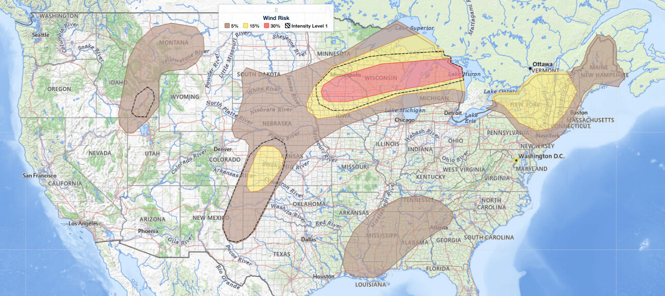
Midwest severe thunderstorms are forecast to bring dangerous weather across the Upper Midwest and Great Lakes region on Wednesday, July 1, 2026. The NOAA Storm Prediction Center has issued an Enhanced Risk, the third of five severe categories (level 3 of 5), for portions of that corridor, with damaging wind gusts up to 80 mph, large to very large hail, and isolated tornadoes all on the table.
Key points:
- Enhanced Risk (level 3 of 5) covers parts of the Upper Midwest and Great Lakes.
- Wind gusts near 80 mph are possible in the Enhanced Risk area.
- Large to very large hail and a few tornadoes are also expected.
- A second round of storms is likely during the afternoon and evening near southern Minnesota.
- Slight Risk areas include the central High Plains and the Northeast.
Where and When the Midwest Severe Thunderstorms Will Strike
The SPC’s forecast discussion points to southern Minnesota as the initial focal point for the Midwest severe thunderstorms this morning, with storms expected to spread east-northeastward into the broader Upper Midwest and Great Lakes as the day progresses. A stationary boundary running through the region will serve as the organizing axis for storm development throughout the day and into tonight.
A second, distinct round of storm development is expected during the afternoon and evening hours, again initiating near southern Minnesota. That second wave will push east-northeast through a strongly unstable air mass, making it potentially the more significant round of the two. Both rounds carry a risk for all three major severe hazard types: damaging wind, hail, and tornadoes.
Beyond the Enhanced Risk zone, the SPC also placed parts of the central High Plains and the Northeast under a Slight Risk, the second of five severe categories (level 2 of 5). High-based thunderstorms are expected to fire along a north-south-oriented dryline over the High Plains during the afternoon and evening, capable of producing severe wind gusts and large hail. SPC uses a five-tier system to communicate severe weather potential; you can learn more about each category in this guide to SPC outlook risk categories.
The SPC’s maximum hazard probabilities within the risk areas are: tornado 5 percent, large hail 15 percent, and damaging wind 30 percent.
Meteorologist’s Take
The engine driving today’s Midwest severe thunderstorms is a convectively enhanced shortwave impulse riding within a belt of strong southwesterly winds at mid-levels, stretching from the central and northern Plains into the Upper Midwest and Great Lakes. In plain terms, a fast-moving ripple in the upper-level wind pattern is providing the lift needed to organize severe storms. That lift combines with a very unstable low-level air mass, fueled by daytime heating and steep lapse rates, meaning air near the surface will rise rapidly once triggered.
Wind shear, the change in wind speed and direction with height, is a key ingredient for storm organization. The SPC discussion notes around 40 knots of effective shear in the first round and 40 to 50 knots in the second, with increasingly curved wind profiles (clockwise-curved hodographs) during the evening wave. That kind of shear supports a mix of discrete supercells and organized storm clusters. Supercells are the storm mode most efficient at producing large hail and tornadoes, while organized clusters are efficient at producing widespread damaging winds. Both modes are in play here, which is why Midwest severe thunderstorms today carry a multi-hazard signature rather than a single dominant threat.
Over the High Plains, despite weaker deep-layer shear of about 25 to 30 knots, steep lapse rates will still generate a strongly unstable air mass capable of supporting severe wind and hail from loosely organized clusters and possible supercell structures firing along the dryline.
How to Stay Safe in Today’s Midwest Severe Thunderstorms
Because damaging winds up to 80 mph are the primary hazard for Midwest severe thunderstorms today, treat any severe thunderstorm warning as seriously as you would a tornado warning. Winds at that speed can topple trees, collapse weak structures, and turn outdoor furniture and debris into projectiles. Move indoors to a sturdy building and stay away from windows.
Large to very large hail can shatter glass and dent vehicles in seconds. If you are driving when hail begins, pull safely off the road, stay inside the vehicle, and avoid sheltering under highway overpasses, which funnel and intensify hail and wind. Cover your head and face if hail breaks windows.
Although tornadoes are a lower-probability threat today (5 percent per SPC), they remain possible, particularly with supercell storms during the afternoon and evening. Know your shelter location in advance: an interior room on the lowest floor of a sturdy building, away from windows. With two rounds of storms expected through tonight, monitor active weather alerts throughout the day so you have the latest warning information before each wave arrives.
You can also track storm timing and location on live radar and alerts to know exactly when cells are approaching your area.
Given the two-round nature of today’s threat, do not assume the danger has passed after morning storms clear. The afternoon and evening wave near southern Minnesota could equal or exceed the first round in intensity. Stay weather-aware well into tonight as Midwest severe thunderstorms continue pushing east-northeast across the region.
Sources:
Get Severe Weather Alerts for Your Location
When any NWS watch, warning, or advisory is issued for your area, iAlert sends you an immediate notification by email, text message, or phone call, 24 hours a day, 7 days a week.
Sign Up for Severe Weather Alerts →

