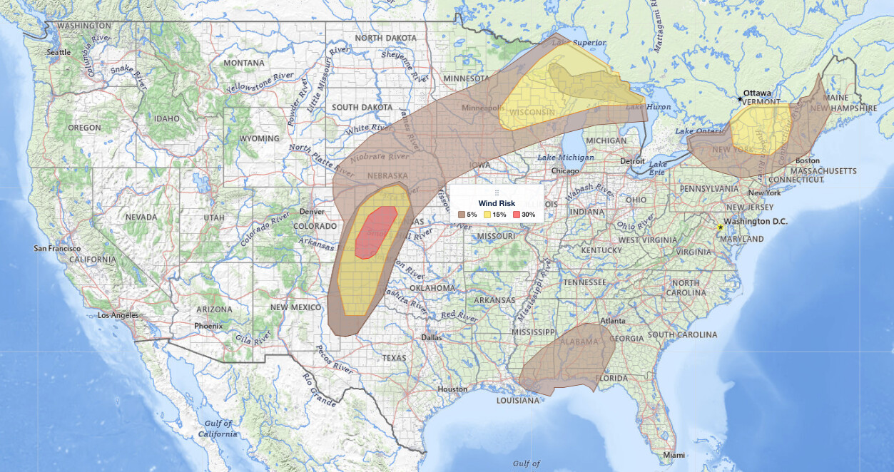
Severe thunderstorms Wisconsin Michigan and the Upper Peninsula face a Slight Risk on June 30, 2026, the second of five severe categories (level 2 of 5) in the NOAA Storm Prediction Center’s Day 1 Convective Outlook. The same outlook raises the threat to an Enhanced Risk (level 3 of 5) over western Kansas, where damaging wind gusts of 60 to 85 mph are possible, and adds separate Slight Risk areas over parts of New York and Vermont.
Within the Wisconsin and Michigan Slight Risk, the SPC carries large hail and damaging wind probabilities near 15 percent and a 5 percent tornado chance, according to the SPC. SPC uses a five-tier system to communicate severe weather potential; you can learn how each risk level is defined on the iAlert SPC outlook explainer.
Key points:
- Enhanced Risk (level 3 of 5) over western Kansas; Slight Risk (level 2 of 5) over northern Wisconsin, Michigan’s Upper Peninsula, parts of New York and Vermont, and the surrounding Plains.
- SPC hazard probabilities: damaging wind up to 30% over western Kansas (60–85 mph gusts); hail and wind near 15% over Wisconsin/Michigan; tornado 5%.
- Supercells capable of large hail and damaging wind are the primary storm mode; a tornado is possible.
- A secondary round of storms is possible late evening into overnight across Nebraska into northern Iowa.
- Dewpoints in the 70s signal the deep moisture fueling extreme instability across the Upper Midwest threat zone.
Where and When Severe Thunderstorms Wisconsin Michigan Will Develop
The SPC outlook places the severe thunderstorms Wisconsin Michigan will see at the core of today’s threat over northern Wisconsin and Michigan’s Upper Peninsula, with storms expected to fire by late afternoon as a southwesterly low-level jet strengthens across central and northern Wisconsin. A frontal boundary stretching southward from a surface low over Manitoba serves as the focal point for storm initiation. Dewpoints in the 70s south and east of that boundary indicate a very moist, unstable air mass primed for explosive storm development.
A second, separate Slight Risk area spans parts of New York and Vermont, where enhanced northwesterly flow aloft interacts with the northeastern edge of a high-amplitude ridge over the eastern United States. An Enhanced Risk (level 3 of 5) covers western Kansas, with a Slight Risk across the surrounding central and southern Plains; additional storm development is possible late evening into overnight across Nebraska into northern Iowa as a short-wave impulse rotates through the upper trough and the surface boundary shifts northward. The SPC notes that forecast soundings suggest this overnight activity may remain elevated, keeping confidence in higher probabilities relatively low.
Hazards: Large Hail, Damaging Wind, and a Tornado Threat
Within the Wisconsin and Michigan Slight Risk, the SPC carries large hail and damaging wind probabilities near 15 percent and a 5 percent tornado probability. The day’s highest wind threat is farther southwest, where an Enhanced Risk over western Kansas raises the damaging wind probability to 30 percent with gusts of 60 to 85 mph. Initial storms in the Upper Midwest are expected to develop as discrete supercells, the storm structure most efficient at producing large hail and tornadoes. As storms cluster with time, the SPC warns that the damaging wind hazard could increase, consistent with a transition toward a more organized convective system capable of widespread wind damage.
In the Plains, the threat centers on damaging wind and hail through the late evening and overnight period, though the elevated nature of the storm activity reduces forecaster confidence. Residents across all risk zones should treat any severe thunderstorm warning seriously, as even lower-probability events can produce dangerous conditions with little warning. Check active weather alerts for your area throughout the day and evening.
Meteorologist’s Take
The driving force behind the severe thunderstorms Wisconsin Michigan face today is an upper-level low tracking into Saskatchewan and Manitoba, which tilts the jet stream into a southwest-to-northeast orientation across the northern tier. That setup pulls warm, moist Gulf air northward ahead of the frontal boundary while simultaneously injecting wind shear, the change in wind speed and direction with height, into the storm environment. Strong deep-layer shear is the ingredient that organizes thunderstorms into supercells capable of rotating updrafts and producing large hail.
The extreme instability signaled by those 70-degree dewpoints means storm updrafts will be exceptionally strong, allowing hail to grow large before falling. The afternoon timing is significant: the strengthening low-level jet by late afternoon adds a final surge of moisture and shear just as storm-supporting daylight heating peaks, a classic recipe for an explosive severe weather outbreak. The storm mode is expected to start as discrete supercells, then consolidate into a cluster or quasi-linear system by evening, which is when the wind threat would broaden.
For the Northeast, the mechanism is different. Enhanced northwesterly flow aloft riding over the ridge sets up a less dramatic but still meaningful environment for severe storms across New York and Vermont, explaining the inclusion of those states in the Slight Risk area despite their distance from the main Plains dynamics.
How to Stay Safe During Severe Thunderstorms Wisconsin Michigan and the Northeast
Because the primary hazards for severe thunderstorms Wisconsin Michigan include large hail and damaging wind alongside a tornado threat, your safety actions should reflect all three. Move vehicles into a garage or under a solid overhang before storms arrive, since hail can shatter glass and dent metal in seconds. Stay away from windows during warnings, as hail and wind-driven debris are a serious injury risk indoors.
If a tornado warning is issued for your county, move immediately to an interior room on the lowest floor, away from all windows. For damaging wind threats, treat the hazard like a tornado warning: downed trees and power lines are the leading causes of storm-related fatalities during wind events. Monitor live radar and alerts so you can track storm movement in real time and get iAlert notifications before storms reach your location.
The overnight Plains round adds a complication: many people will be asleep when storms arrive across Nebraska and northern Iowa. Set a weather alert on your phone or use iAlert weather alerts and notifications to ensure you are woken by any warnings issued during that window.
Sources:
Get Severe Weather Alerts for Your Location
When any NWS watch, warning, or advisory is issued for your area, iAlert sends you an immediate notification by email, text message, or phone call, 24 hours a day, 7 days a week.
Sign Up for Severe Weather Alerts →

