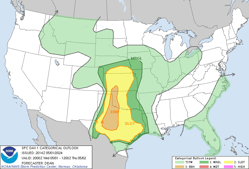
Example Outlook Below
Severe weather outlooks, also commonly referred to as convective outlooks, are issued daily by the National Weather Service Storm Prediction Center in both text and graphic form. iAlert hosts the severe weather outlook graphics which you can access by clicking here.
Convective Outlooks are divided into four periods.
| Day 1 | This is the risk of severe weather today through early morning of the following day. Day 1 forecasts are issued five times daily; 06z (around midnight), 13z (around sunrise), 1630z (mid-morning), 20z (mid-afternoon), and 01z (early evening). |
|---|---|
| Day 2 | Day 2 continues from the ending of Day 1 (tomorrow morning) for the next 24 hours. These are issued twice daily; 07z (around midnight) and 1730z (around noon). |
| Day 3 | This is the forecast for the subsequent 24 hours. Day 3 forecasts are issued daily by 0830z on standard time and 0730z on daylight time (after midnight). |
| Days 4-8 | A severe weather area depicted in the Day 4-8 period (issued at 10z (early morning) indicates a 30% or higher probability for severe thunderstorms (e.g. a 30% chance that a severe thunderstorm will occur within 25 miles of any point). |
The convective outlook graphics display up to six different color categories to reflect an increase in the likelihood of occurrence and/or increased severity of a severe weather event.
General Thunderstorms
The light green shading depicts a 10% or higher probability of non-severe or near severe thunderstorms during the valid period.
Severe Category 1 – MarginalThe dark green shading area indicates a marginal (MRGL) risk of severe thunderstorms during the forecast period. This means a…
|
Severe Category 2 – SlightThe yellow shaded area indicates a slight (SLGT) risk of severe thunderstorms during the forecast period. This means a…
|
Severe Category 3 – EnhancedThe orange shaded area indicates an enhanced (ENH) risk of severe thunderstorms during the forecast period. This means a…
|
Severe Category 4 – ModerateThe red shaded area indicates a moderate (MDT) risk of severe thunderstorms are expected. This means a…
|
Severe Category 5 – HighThe fuschia shaded area indicates a high (HIGH) risk of severe thunderstorms are expected. This means a…
|
These are the official definitions. The reason for the “AND’s”, “OR’s” and “WITH OR WITHOUT’s” is to help cover the many different states that occur in the atmosphere. There will be times when the number of severe weather events will be high but the overall intensities will not necessarily be extreme.
There will be other times when the atmosphere will be extremely unstable and will produce extreme damaging weather but the number of events will be fairly small. Or any combination of the above. Confused?!? Just know that the greater the threat (from Slight to High), the greater the risk for severe weather which could be either in number of events or intensity or both.
Click below to view current convective outlooks for Day 1, 2, and 3

Related Articles:
- How tornadoes form
- Tornado facts
- Tornado Safety
- Lightning Safety
- Flood Safety
- Tornado Myths
- Lightning Myths
- Life cycle of thunderstorms
- Criteria for a tornado warning
- Criteria for a severe thunderstorm
- Difference between “flood” and “flash flood”
Sign-up For Severe Weather Email & Text Message Alerts


