
View All Articles

Wintery Mix to Hit Northeast Friday into Saturday (Jan 23-24 2015)

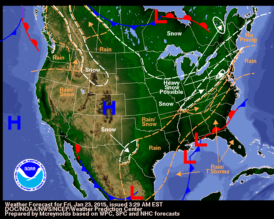
Forecast Chart for Wintery Mix to Hit Northeast Friday into Saturday (Jan 23-24 2014)

Forecast Chart for Wintery Mix to Hit Northeast Friday into Saturday (Jan 23-24 2015)

The storm system that brought heavy snow to parts of the southern Plains will continue to develop as it moves up the Eastern Seaboard late Friday January 23, 2015 into Saturday January 24, 2015.  The system has the potential to bring a wintry mix of precipitation to the mid-Atlantic & New England, though it is not expected to be a major snow producer, along with heavy rain and isolated severe thunderstorms across the Southeast. Review all email/text alert notification services for weather: http://ialert.com/services Receive email/text storm reports (snow amounts, wind damage, & more): http://ialert.com/services/product-details.php?pro-id=19 Severe Weather Text and Email Alerts by City: http://ialert.com/services/product-details.php?pro-id=15  
This entry was posted in Weather Articles and tagged , , , , , , , , , . Bookmark the permalink.

Leave a Reply

Read More

Hawaii tropical storm forecast track for Potential Tropical Cyclone One-C on August 13, 2026, showing the National Hurricane Center forecast cone crossing the Hawaiian Islands from Friday night into Monday with the center passing near Hilo and Honolulu

Hawaii Tropical Storm Threat: Potential Tropical Cyclone One-C Targets the Islands

Forecast track and cone for Potential Tropical Cyclone One-C, valid 12:00 UTC August 13, 2026 (2 a.m. HST). The track carries the center from east-southeast of the Big Island on Thursday to near or over the…

Read More

Iowa Illinois severe thunderstorms SPC Day 1 categorical risk map for August 13, 2026, showing a Slight Risk from Des Moines across Cedar Rapids, Davenport, Peoria, and Champaign, with a Marginal Risk wrapping from the central Plains into Indiana, Ohio, and Kentucky

Iowa Illinois Severe Thunderstorms: Slight Risk of Damaging Wind and Hail August 13, 2026

Iowa Illinois severe thunderstorms are the top convective concern in the NOAA Storm Prediction Center's Day 1 Outlook issued at 05:58 UTC on August 13, 2026. The SPC has drawn a Slight Risk, the second of…

Read More

Plains severe thunderstorms SPC categorical risk map for August 12, 2026, showing a Slight Risk from the northern and central High Plains across Nebraska and Iowa into Illinois, Indiana, and the lower Ohio Valley

Plains Severe Thunderstorms: Slight Risk of Large Hail and Damaging Wind From Iowa to the High Plains, August 12, 2026

Plains severe thunderstorms are the top weather story for Wednesday, August 12, 2026. The NOAA Storm Prediction Center has issued a Slight Risk, the second of five severe categories, from the central and northern High Plains…

Read More

Leave a Reply

