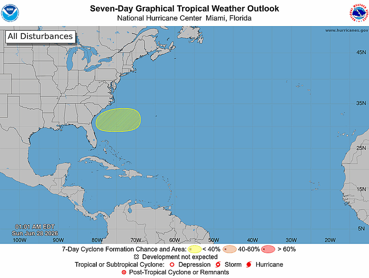
Atlantic tropical development is possible off the southeastern coast of the United States as early next week, according to a National Hurricane Center outlook issued at 2:00 PM EDT on Saturday, June 27, 2026. The system carries a low formation chance of near 0 percent within 48 hours, rising to 20 percent over the next seven days, placing it in the low-risk category for now.
Key points:
- A low pressure area is expected to form along the western end of a frontal system.
- Affected area: offshore southeastern United States coast.
- 48-hour formation chance: near 0 percent.
- 7-day formation chance: 20 percent (low risk).
- System expected to move slowly westward after development begins.
What the NHC Is Watching
The National Hurricane Center’s Forecaster Beven identified a low pressure area forecast to develop at the western end of a frontal boundary situated near the southeastern U.S. coast. Frontal boundaries in this region during late June can sometimes anchor disorganized convection, and as the front weakens, a remnant low occasionally finds enough warm sea-surface temperatures and low wind shear to attempt slow organization.
The projected slow westward movement is a detail worth watching. A system tracking west along or near the Southeast coast could bring increasing rain, gusty winds, and dangerous surf to coastal Georgia, South Carolina, North Carolina, and northern Florida even if it never achieves tropical storm status. Interests in those areas should monitor updates over the coming days.
A 20-percent, seven-day formation probability means the odds still favor no development, but one-in-five is not negligible during an active Atlantic hurricane season. The NHC issues updated outlooks four times daily, and probabilities can shift quickly as models ingest new data.
Atlantic Tropical Development in Late June: The Meteorological Context
Late June sits at the front edge of the statistical peak of Atlantic hurricane season, which runs June 1 through November 30. Sea-surface temperatures along the Southeast U.S. coast are typically approaching their summer maximum by late June, often ranging from the upper 70s to low 80s Fahrenheit, warm enough to support at least some tropical convective organization. The challenge for a system forming this far north is that upper-level wind shear tends to be higher than in the deep tropics, which can inhibit the symmetric, warm-core structure a tropical cyclone needs.
Frontal-boundary interactions, sometimes called “frontal cyclogenesis,” are a recognized pathway for subtropical or tropical development in the western Atlantic. When a frontal low stalls or cuts off from the main jet stream, it can gradually acquire tropical characteristics if oceanic heat flux is sufficient. This process typically unfolds slowly, which matches the NHC’s description of “slow development” in this outlook.
Meteorologist’s Take
A 20-percent formation probability is worth monitoring but not cause for immediate alarm. At this stage, the atmosphere and ocean have not yet committed to a development pathway. The slow westward drift, however, is the detail that makes this system potentially impactful for the Southeast coast regardless of classification. Tropical or subtropical systems do not need to carry a name to produce hazardous surf, rip currents, and heavy rainfall.
Residents and travelers along the southeastern coastline should keep an eye on updates through the holiday week. If atmospheric wind shear relaxes and the low tracks over warmer shelf waters, probabilities could climb noticeably in later outlooks. Check the active weather alerts on iAlert to stay current on any watches or advisories issued for your area as this system evolves.
How to Stay Safe
Even a low-probability Atlantic tropical development scenario warrants basic preparedness steps for Southeast coastal residents. First, check your local weather forecast daily through early next week so you catch any rapidly changing outlooks. Second, avoid entering the ocean when rip current flags are flying. Developing low-pressure systems routinely generate dangerous surf and rip currents well before any tropical designation is assigned. Third, if you live in a flood-prone coastal or low-lying area, review your evacuation route now while there is no pressure to act quickly.
Keep in mind that the NHC issues four outlooks per day, and formation probabilities can jump significantly within 24 hours. Setting up weather alerts through a service like iAlert weather alerts and notifications ensures you receive timely warnings without having to check manually. Atlantic tropical development situations like this one can escalate faster than the weekly forecast cycle, so real-time alerts matter.
Sources:


