
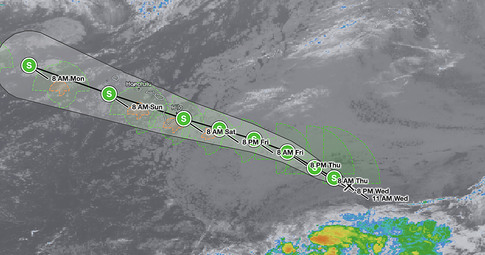
A Hawaii tropical storm threat is now forecast to reach the islands late Friday. The NOAA Central Pacific Hurricane Center is issuing advisories on Potential Tropical Cyclone One-C, which its 11 p.m. HST Wednesday bulletin placed about 775 miles east-southeast of Hilo with maximum sustained winds of 40 mph. The system is expected to become a tropical storm by Thursday night and to strengthen as it moves west-northwestward near or over the island chain into the weekend.
The Central Pacific Hurricane Center’s own headline on the advisory is blunt: the system is forecast to bring heavy rainfall, high winds and dangerous surf to the Hawaiian Islands starting late Friday.
Key points:
- The Hawaii tropical storm rainfall forecast is 5 to 10 inches across much of the island chain, with local totals up to 20 inches.
- The center was about 775 miles east-southeast of Hilo at 11 p.m. HST Wednesday, moving west at 10 mph.
- Formation chance is 90% through both 48 hours and 7 days.
- Heavy rain reaches the Big Island first on Friday, then spreads west across the chain over the weekend.
- A Hurricane or Tropical Storm Watch was expected for part of the state by early Thursday.
Get Lightning Detection Alerts for Your Location
When dangerous lightning is detected near your area, iAlert sends you an immediate notification by email, text message, or phone call, so you know when to seek shelter and when it is safe to head back outside.
Sign Up for Lightning Detection Alerts →Where Potential Tropical Cyclone One-C Is Now
At 11 p.m. HST Wednesday (0900 UTC Thursday), the disturbance was centered near latitude 14.8 North, longitude 144.5 West. That put it about 775 miles east-southeast of Hilo and about 985 miles east-southeast of Honolulu, moving west at 10 mph with a minimum central pressure of 1002 millibars.
By the 2 a.m. HST Thursday outlook the center of the developing Hawaii tropical storm had closed to about 750 miles east-southeast of Hilo. Formation chance stood at 90% through both 48 hours and 7 days, the top of the Central Pacific Hurricane Center’s “high” category.
One detail matters more than the center position for anyone planning around this Hawaii tropical storm: tropical-storm-force winds already extend outward up to 275 miles from the center, and almost all of that is on the northeast side. A system that broad can deliver impacts to an island the center never reaches.
What Is a Potential Tropical Cyclone?
The designation is often misread. A Potential Tropical Cyclone is a disturbance that is not yet a tropical cyclone but that poses the threat of tropical storm or hurricane conditions to land areas within 48 hours. The label exists for one reason: it lets forecasters issue watches and warnings before the system formally organizes, instead of waiting and losing lead time.
In this case the disturbance already has 40 mph winds, but forecasters noted it still lacks the organized shower and thunderstorm activity near a defined center that would make it a tropical storm. Satellite wind data showed the strongest winds sitting roughly 200 miles northeast of the center rather than wrapped around it.
That is a distinction of classification, not of consequence. The rainfall and surf forecasts do not wait for the naming.
The Hazards Behind This Hawaii Tropical Storm Threat
Rainfall is the headline hazard of this Hawaii tropical storm. The Central Pacific Hurricane Center forecasts 5 to 10 inches across much of the island chain, with maximum totals of 20 inches possible. Forecasters warn this rainfall may produce life-threatening flooding and mudslides, especially in areas of steep terrain, which describes most of the populated windward slopes in Hawaii.
Timing for the Hawaii tropical storm runs west across the chain. Heavy rain begins on the Big Island Friday, then spreads westward over Maui County, Oahu and Kauai during the weekend.
Surf is the second Hawaii tropical storm hazard. Swells generated by the system are expected to reach east-facing shores of the state on Friday, then spread westward and build through the weekend. Forecasters expect life-threatening surf and rip current conditions.
Wind is the third. The advisory states there is an increasing risk of wind impacts in the Hawaiian Islands regardless of the exact track. That phrase is deliberate: the wind threat does not hinge on a direct hit.
Meteorologist’s Take on the Hawaii Tropical Storm Forecast
A large high pressure system north of the Hawaiian Islands is the steering feature here. It should push the disturbance generally west-northwestward for the next several days, which is what carries the track toward the chain rather than harmlessly south of it.
Confidence in that track is lower than usual, and forecasters said so plainly. The guidance shifted somewhat south of the previous cycle, and the track forecast will stay low confidence until a better-defined center forms. A sprawling system can relocate its center as it organizes, which shifts the whole forecast with it.
Intensity has a genuine tug-of-war in it. The environment over the next two days favors strengthening, but the system’s broad structure means that strengthening should be gradual. As it nears Hawaii, southwesterly wind shear, dry air being drawn in, and interaction with the terrain of the Big Island should slow or stop intensification.
There is a caveat worth holding onto: if the system tracks farther south of Hawaii than forecast, it stays in more favorable conditions and would likely end up stronger than currently predicted. A track error south is not automatically good news.
For residents, the practical read on this Hawaii tropical storm is that the rainfall and surf forecasts are far more reliable right now than the exact center position. Prepare for water, not for a landfall point.
How to Prepare for a Hawaii Tropical Storm
Because heavy rain and flooding lead this Hawaii tropical storm, preparation should start with water, not wind. Know whether your home sits in a flood-prone area, near a stream, or below a steep slope where mudslides are a risk. Those are the areas 20 inches of rain will find first.
Clear gutters and drains now while conditions are calm. Move vehicles off low ground. Never drive through a flooded road. More than half of all flood drownings happen when a vehicle is driven into water, because neither the depth nor whether the roadbed is still there can be judged from behind the wheel.
Secure anything outdoors that wind can lift, and stock at least 72 hours of water, non-perishable food, medications and important documents in a waterproof container. Fill your gas tank and pick up supplies before a watch is upgraded, since those resources go quickly.
Stay out of the ocean once east-facing Hawaii tropical storm swells build Friday. Life-threatening surf and rip currents are forecast, and those conditions arrive ahead of the storm itself. Monitor active weather alerts and track the latest local forecast as the system approaches.
Hawaii Tropical Storm FAQ
When will Hawaii tropical storm conditions begin?
Late Friday. The Central Pacific Hurricane Center forecasts heavy rainfall, high winds and dangerous surf beginning across the islands starting late Friday, with the center nearing the chain by that evening. Surf on east-facing shores builds beginning Friday.
Which island does the Hawaii tropical storm hit first?
The Big Island. Heavy rainfall is forecast to begin affecting Hawaii Island on Friday and then spread westward across Maui County, Oahu and Kauai during the weekend, following the storm’s west-northwestward motion.
How much rain is forecast with this Hawaii tropical storm?
5 to 10 inches across much of the island chain, with maximum totals of 20 inches possible. Forecasters warn this may produce life-threatening flooding and mudslides, particularly in areas of steep terrain.
Has a tropical storm watch been issued for Hawaii?
Not as of the 2 a.m. HST Thursday outlook. The Central Pacific Hurricane Center said a Hurricane or Tropical Storm Watch would likely be required for a portion of the state by early Thursday, and advised that interests throughout the Hawaiian Islands closely monitor the system.
Will it be a hurricane when it reaches the islands?
Not as forecast. The system is expected to become a tropical storm by Thursday night and strengthen gradually, with shear, dry air and terrain interaction expected to slow or halt that strengthening near the islands. A hurricane watch was still listed as a possibility, so the forecast is not settled.
What about the other system in the Pacific?
That is Tropical Storm Hernan, unrelated to the Hawaii tropical storm threat, recently upgraded and located well west of the southern tip of the Baja California Peninsula in the eastern Pacific. It is a separate system and is not a threat to Hawaii.
Sources:
- NOAA Central Pacific Hurricane Center, Potential Tropical Cyclone One-C Public Advisory Number 4, 11:00 PM HST August 12, 2026
- NOAA Central Pacific Hurricane Center, Potential Tropical Cyclone One-C Forecast Discussion Number 4
- NOAA Central Pacific Hurricane Center, Central North Pacific Tropical Weather Outlook, 2:00 AM HST August 13, 2026
Get Severe Weather Alerts for Your Location
When any NWS watch, warning, or advisory is issued for your area, iAlert sends you an immediate notification by email, text message, or phone call, 24 hours a day, 7 days a week.
Sign Up for Severe Weather Alerts →

