
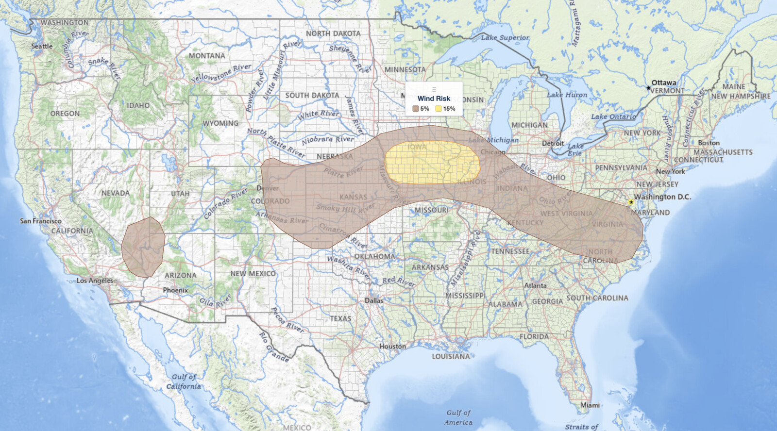
Missouri Valley severe thunderstorms are the headline concern in the NOAA Storm Prediction Center’s Day 1 Convective Outlook issued at 12:47 UTC on August 14, 2026, with a Slight Risk covering a corridor from Omaha, Nebraska, through Des Moines and Cedar Rapids, Iowa, and into Peoria and Bloomington, Illinois. Forecasters Mosier and Dean write that strong to severe thunderstorms will be possible this afternoon and evening across the mid Missouri and mid Mississippi Valleys, with damaging wind gusts as the primary hazard and a brief tornado also possible.
Key points:
- A Slight Risk (level 2 of 5) for Missouri Valley severe thunderstorms centered on Omaha, Des Moines, Cedar Rapids, the Quad Cities, and Peoria.
- The 15% damaging wind area covers 56,970 square miles and 3,664,888 people, and it matches the Slight Risk outline exactly.
- A 2% tornado probability spans 30,047 square miles from Des Moines east to Moline, Illinois.
- A 5% large hail probability applies separately to the Denver area and to the Omaha to Des Moines corridor.
- A Marginal Risk runs from Denver and Kansas City through Chicago and Indianapolis to the Virginia coast, plus a separate area over southern Nevada.
Get iAlert Notifications for Your Location
The moment a threat is issued for your area, iAlert sends an immediate alert by email, text message, or phone call, 24/7. Choose the alerts you need:
Severe Weather Alerts → ⚡ Lightning Detection Alerts →Where Missouri Valley Severe Thunderstorms Are Most Likely Today
The Slight Risk is the second of five categories on the SPC scale; for the full breakdown see the iAlert guide to SPC outlook risk categories. Today it covers Omaha NE, Council Bluffs IA, Des Moines IA, West Des Moines IA, Ames IA, Cedar Rapids IA, Iowa City IA, Davenport IA, Moline IL, Ottumwa IA, Burlington IA, Peoria IL, Bloomington IL, and Galesburg IL.
One detail is worth pulling out of the maps. The 15% damaging wind polygon and the Slight Risk polygon are the same shape, so every city in the category carries the 15% wind probability and no city outside it does. Damaging wind by itself is what lifted this corridor to Slight, and SPC puts that area at 56,970 square miles covering 3,664,888 people.
The 2% tornado probability sits entirely inside the Missouri Valley severe thunderstorms corridor but covers a narrower footprint, 30,047 square miles and 1,945,843 people. It takes in Des Moines, West Des Moines, Cedar Rapids, Iowa City, Davenport, Moline IL, Galesburg IL, Ottumwa, and Burlington. It does not reach Omaha, Council Bluffs, Peoria, or Bloomington.
The hazard footprints diverge again on hail. Peoria, Bloomington, Davenport, Moline, and Galesburg sit inside the Slight Risk but carry no 5% large hail probability, while Omaha, Council Bluffs, Des Moines, Ames, Cedar Rapids, Iowa City, Ottumwa, and Burlington do. Anyone reading only the categorical map misses that split, which is why today’s Missouri Valley severe thunderstorms need to be read hazard by hazard rather than by color alone.
A second, disconnected 5% hail area covers the Colorado Front Range: Denver, Aurora, Colorado Springs, Pueblo, Limon CO, and Cheyenne WY. Those cities sit in the Marginal Risk categorically, yet they carry the same top hail probability as the Iowa and Nebraska corridor. Across both areas the 5% hail probability spans 85,889 square miles and 6,429,204 people.
The Marginal Risk zone outside the Missouri Valley severe thunderstorms core is large, and a 5% damaging wind probability covers nearly all of it: 424,122 square miles and 48,228,215 people. It runs from Denver and Cheyenne east through Wichita KS, Topeka KS, Kansas City MO, Chicago IL, Rockford IL, Joliet IL, Champaign IL, Springfield IL, Gary IN, Lafayette IN, Indianapolis IN, Cincinnati OH, Louisville KY, and Charleston WV, then on to Roanoke VA, Richmond VA, Norfolk VA, Greensboro NC, and Raleigh NC. A separate Marginal area covers Las Vegas NV and the surrounding southern Nevada desert.
Meteorologist’s Take on Missouri Valley Severe Thunderstorms
The SPC’s reasoning for today’s Missouri Valley severe thunderstorms centers on a well-defined mesoscale convective vortex (MCV), the spinning remnant left behind by a dying cluster of storms, generated by overnight convection across Kansas and Nebraska. At issuance an extensive band of showers and thunderstorms ran from northeast Nebraska southeastward across central Iowa, central Illinois, and central Indiana, supported by warm-air advection along a broad, diffuse frontal zone from southeast Nebraska across northern Missouri and southern Illinois.
That band should wane through the morning as the low-level jet driving the warm-air advection weakens. The afternoon phase of the Missouri Valley severe thunderstorms then turns on how much the air mass recovers along the southern edge of the band, ahead of the MCV, where ample low-level moisture is already in place.
Differential heating between the residual cloud debris and the clearer air south of it could produce a warm-front-like zone across southern Iowa or northern Missouri. Where that boundary sets up, how strong it gets, and exactly where it lands all remain uncertain, largely because of the limited predictability of how the ongoing precipitation evolves. That single uncertainty is what makes today’s threat hard to pin to a specific county this far ahead.
The air mass along and south of the boundary is forecast to destabilize and become moderately to strongly unstable by late afternoon. Low-level convergence there should be augmented by mesoscale ascent tied to the MCV, and that combination of lift and buoyancy will support storm development. A belt of stronger mid-level flow could accompany the MCV, delivering enough deep-layer shear to organize any persistent updrafts.
Strong gusts from water-loaded downdrafts and from any bowing segments are the primary severe risk with these Missouri Valley severe thunderstorms. The boundary combined with southeasterly low-level flow also supports a brief tornado, particularly early in the convective cycle when a more cellular storm mode is likely.
The Ohio Valley, central Appalachians, and Mid-Atlantic carry their own reasoning. Showers ongoing from Illinois into Ohio should weaken this morning, but the cloud cover they leave behind could reinforce a modest baroclinic zone from southern Illinois across southern Indiana and southern Ohio and through central West Virginia and central Virginia. A modest vorticity maximum over central Illinois is forecast to track southeast along and north of that boundary.
Vertical shear in that eastern corridor will be weak, so organized storms are not the concern there. Strong updrafts feeding on ample moisture are, and the SPC flags a threat for wet microbursts: sudden, localized downbursts of rain-cooled air that hit the ground and spread out as damaging straight-line wind. That is the mechanism behind the 5% wind probability from Louisville and Cincinnati east to Richmond and Norfolk.
Over the central High Plains, a shortwave trough moving through the lower Colorado River Valley will continue northeastward through the Four Corners. Ascent from that wave combines with orographic lift in the Rockies foothills to support scattered initiation by early afternoon, with storms then moving northeast into a moderately buoyant air mass. Deep-layer shear there is modest but sufficient for a few organized updrafts capable of hail and damaging gusts, which is what earns Denver and Colorado Springs their 5% hail probability.
In southern Nevada, dewpoints in the 60s across southern California, the lower Colorado River Valley, and southern Arizona combine with strong daytime heating to produce moderate buoyancy. Slightly stronger mid-level flow over southern Nevada supports isolated strong gusts around Las Vegas.
How to Stay Safe During Missouri Valley Severe Thunderstorms
Because the primary hazard with today’s Missouri Valley severe thunderstorms is damaging wind, with a tornado threat across the Iowa and western Illinois portion, residents from Omaha and Des Moines through Cedar Rapids, the Quad Cities, and Peoria need a way to receive warnings before storms arrive. Sign up for iAlert weather alerts and notifications to get real-time severe weather warnings sent directly to you, and watch live radar as storms develop this afternoon and evening.
If a tornado warning is issued, move immediately to the lowest floor of a sturdy building and put as many walls between you and the outside as possible. Stay away from windows. A 2% tornado probability is low in absolute terms, but lead time on a brief tornado near a surface boundary is short, so the plan has to exist before the watch is issued.
For damaging wind, treat any severe thunderstorm warning with the same urgency during these Missouri Valley severe thunderstorms. Secure or bring in outdoor furniture and anything that could become a projectile, stay indoors and away from windows, and avoid parking under large trees. Wet microbursts in the Ohio Valley and Mid-Atlantic can produce damaging gusts with little visual warning beyond a heavy rain shaft.
In the Denver and Colorado Springs area, where the 5% hail probability applies despite the lower categorical tier, vehicles parked outside are the main exposure. Move cars into a garage or covered parking before storms initiate in the early afternoon, several hours ahead of the evening peak farther east.
Missouri Valley Severe Thunderstorms FAQ
Where is the highest risk for Missouri Valley severe thunderstorms today?
The Slight Risk is the highest tier drawn anywhere in today’s outlook. It covers Omaha NE, Council Bluffs IA, Des Moines IA, West Des Moines IA, Ames IA, Cedar Rapids IA, Iowa City IA, Davenport IA, Moline IL, Ottumwa IA, Burlington IA, Peoria IL, Bloomington IL, and Galesburg IL.
How strong could wind gusts get?
The SPC assigns a 15% damaging wind probability to the Missouri Valley severe thunderstorms corridor, meaning a 15% chance of a damaging wind report within 25 miles of any given point. The discussion names strong gusts from water-loaded downdrafts and bowing segments as the primary threat. The outlook does not specify an explicit gust speed.
Are tornadoes expected with today’s Missouri Valley severe thunderstorms?
The SPC places a 2% tornado probability over Des Moines, West Des Moines, Cedar Rapids, Iowa City, Davenport, Moline, Galesburg, Ottumwa, and Burlington. The discussion says a brief tornado is possible, particularly early in the convective cycle when a more cellular storm mode is likely near the surface boundary.
When will storms develop and move through the region?
The morning storm band is expected to weaken, with the main development tied to afternoon destabilization along a boundary across southern Iowa or northern Missouri. Missouri Valley severe thunderstorms should run through the afternoon and evening, and this outlook is valid until 7 a.m. CDT Saturday, August 15.
is valid until 7 a.m. CDT Saturday, August 15.Why are Denver and Las Vegas in an outlook about Missouri Valley severe thunderstorms?
They sit in separate risk areas covered by the same national Day 1 outlook. Denver and Colorado Springs carry a 5% large hail probability from High Plains storms firing off the Rockies foothills, and southern Nevada carries a 5% wind probability from isolated strong gusts. Neither is connected to the Iowa corridor.
Sources:
- NOAA Storm Prediction Center, Day 1 Convective Outlook, issued 12:47 UTC August 14, 2026 (SPC AC 141247, Mosier/Dean)
- NOAA Storm Prediction Center, current Day 1 Convective Outlook
Get Severe Weather Alerts for Your Location
When any NWS watch, warning, or advisory is issued for your area, iAlert sends you an immediate notification by email, text message, or phone call, 24 hours a day, 7 days a week.
Sign Up for Severe Weather Alerts →

