
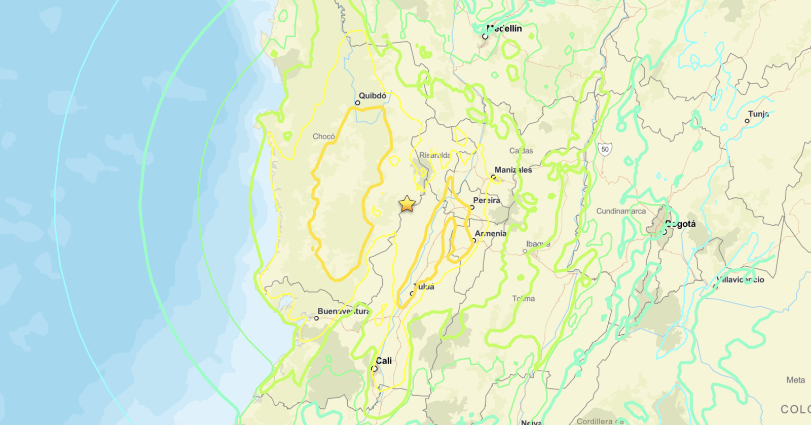
Colombia earthquake M7.4 struck approximately 5 kilometers east of San José del Palmar on August 10, 2026, at 12:34 UTC (7:34 a.m. local time), generating ShakeMap intensity values of VII and Did You Feel It? reports reaching VIII, indicating very strong to severe shaking across a wide area. The USGS PAGER loss-estimate alert remained pending at the time of this report, meaning casualty and economic impact figures had not yet been released.
Key points:
- Magnitude 7.4 earthquake, among the largest to strike Colombia in recent years.
- Epicenter 5 km east of San José del Palmar, Chocó department, Colombia.
- Depth: 107 km (66.5 miles), classified as an intermediate-depth event.
- ShakeMap intensity VII (very strong); DYFI crowd-sourced reports reached intensity VIII (severe).
- Shaking modeled across the Chocó and Cauca Valley corridor, including Pereira, Armenia, Manizales and Tuluá.
- Epicenter roughly 135 km inland at 107 km depth, so no tsunami threat.
- USGS PAGER casualty and damage alert was still pending as of publication.
What We Know About the Colombia Earthquake M7.4
The Colombia earthquake M7.4 was centered at 4.903°N, 76.189°W, placing the epicenter in the western Andes foothills of Chocó department, a rugged and sparsely populated region. The event occurred at a depth of 107 kilometers, which classifies it as an intermediate-depth earthquake under the standard seismological definition of 70 to 300 kilometers. That depth is a critical factor in understanding how widely shaking spread.
ShakeMap, the USGS automated ground-motion mapping tool, assigned Modified Mercalli Intensity (MMI) VII to the epicentral area, corresponding to very strong shaking where poorly built structures face damage and well-built ones may sustain moderate damage. Crowd-sourced Did You Feel It? (DYFI) responses pushed perceived intensity to VIII, the level USGS labels severe, suggesting that shaking felt by residents was more pronounced than the instrument-based estimate in certain spots.
The epicenter sits roughly 135 kilometers inland from the Pacific coast, and the rupture occurred 107 kilometers below the surface. Neither condition supports tsunami generation, and no tsunami threat was associated with this event.
Where the Colombia Earthquake M7.4 Was Felt
ShakeMap contours place the strongest modeled shaking over the epicentral zone in Chocó and across the neighboring coffee-belt corridor. Pereira, Armenia, Manizales, Cartago and Tuluá all fall inside the higher-intensity bands, with Pereira roughly 55 kilometers east of the epicenter and Armenia and Manizales each about 70 to 75 kilometers away.
Lighter shaking extended well beyond that core. Quibdó, Buenaventura and Cali sit inside the outer contours, and the weakest modeled bands reach Medellín roughly 165 kilometers to the northeast and Bogotá roughly 235 kilometers to the east. A felt footprint that large across mountainous terrain is characteristic of a deep event, not a shallow one.
Meteorologist’s Take
Though earthquakes fall outside traditional meteorology, hazard communication is a core part of what we do at iAlert. The Colombia earthquake M7.4 is notable for its intermediate depth. Shallower quakes, those less than 70 kilometers down, tend to cause more localized but intense surface damage. Intermediate-depth events like this one distribute energy across a much broader footprint, sometimes producing noticeable shaking hundreds of kilometers from the epicenter.
A magnitude 7.4 releases roughly 32 times more seismic energy than a magnitude 6.4. At 107 kilometers beneath the northern Andes, the rupture most likely occurred inside the subducting Nazca plate rather than on the shallower plate boundary itself. The gap between the ShakeMap instrumental intensity of VII and the DYFI perceived intensity of VIII is not unusual: building resonance, local geology, and soil amplification can make shaking feel stronger than raw ground-motion data suggests.
The pending PAGER alert is the most important unknown right now. PAGER correlates estimated shaking with population exposure and regional construction vulnerability to project probable casualty ranges. Because San José del Palmar sits in a remote, mountainous zone, access for damage assessment teams may be slow, and landslide hazard in steep Andean terrain is a serious secondary concern after any large earthquake in this region.
Safety Steps After the Colombia Earthquake M7.4
If you felt the shaking and are still inside a structure, the immediate step during any renewed motion is to drop, cover, and hold on until it fully stops. Once shaking ends, move away from damaged buildings and stay alert for aftershocks, which can follow a M7.4 main shock for days to weeks, sometimes at magnitudes above 6.0.
In steep Andean terrain, heavy rain or aftershock vibration can trigger landslides on slopes already destabilized by the main shock. Avoid river valleys and canyon bottoms near the epicenter until local authorities confirm those routes are clear. Follow official guidance from Colombia’s Servicio Geológico Colombiano and local emergency management agencies for evacuation orders or shelter-in-place directives.
Stay informed through real-time alerts. You can monitor active weather and hazard alerts on iAlert for ongoing updates as the situation develops.
Colombia Earthquake M7.4 FAQ
How deep was the Colombia earthquake M7.4?
The Colombia earthquake M7.4 struck at a depth of 107 kilometers, making it an intermediate-depth event. That depth caused shaking to spread across a wide area rather than concentrating damage near a single point.
What was the ShakeMap intensity level?
ShakeMap assigned MMI VII, described by USGS as very strong, to the epicentral area. Did You Feel It? crowd-sourced reports from residents reached intensity VIII, described as severe, in some locations.
Was there a tsunami threat?
No. The epicenter was roughly 135 kilometers inland from the Pacific coast at a depth of 107 kilometers. Deep inland ruptures of this type do not displace seawater, so no tsunami was generated.
Has PAGER issued a damage or casualty estimate?
As of the time of this report, the USGS PAGER alert for this event was still pending. No official casualty or economic loss figures had been released.
Should residents expect aftershocks?
Yes. A magnitude 7.4 main shock typically generates aftershocks for days to weeks. Some aftershocks following an event this size can exceed magnitude 6.0 and cause additional damage to already weakened structures.
This report on the Colombia earthquake M7.4 reflects USGS data available at the time of publication. Magnitude, depth, and intensity values are routinely revised as more seismic stations report, and the PAGER alert level may change once it is issued. We will update this page as new information is released.
Sources:
- USGS Earthquake Hazards Program: M 7.4, 5 km E of San José del Palmar, Colombia (August 10, 2026)
- Servicio Geológico Colombiano
Get Severe Weather Alerts for Your Location
When any NWS watch, warning, or advisory is issued for your area, iAlert sends you an immediate notification by email, text message, or phone call, 24 hours a day, 7 days a week.
Sign Up for Severe Weather Alerts →

