
Ohio Valley severe thunderstorms are the top weather story for Tuesday, August 11, 2026. The NOAA Storm Prediction Center has issued an Enhanced Risk, the third of five severe categories, stretching from northern Illinois through Indiana and into the Ohio Valley. The SPC’s 05:00 UTC outlook warns that one or more organized storm clusters could produce damaging wind gusts exceeding 75 mph across this corridor today and tonight.
Key points:
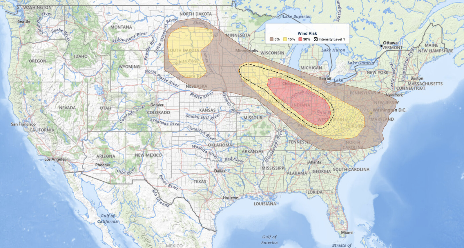
- Enhanced Risk (level 3 of 5) covers Chicago, Indianapolis, Cincinnati, Columbus, Dayton, and Lexington.
- Wind gusts of 75 mph or more are possible if a well-organized storm system tracks from Iowa into the Ohio Valley.
- A 30% damaging wind probability is assigned to the core Enhanced Risk cities, the highest wind probability the SPC has drawn anywhere in the country today.
- A 2% tornado probability covers the Enhanced Risk area, including Chicago and Indianapolis.
- A separate Slight Risk covers the northern Plains, where 15% hail and 15% wind probabilities sit on nearly the same footprint across South Dakota.
- Damaging straight-line wind, not hail and not tornadoes, is the lead hazard for Ohio Valley severe thunderstorms today.
Get Lightning Detection Alerts for Your Location
When dangerous lightning is detected near your area, iAlert sends you an immediate notification by email, text message, or phone call, so you know when to seek shelter and when it is safe to head back outside.
Sign Up for Lightning Detection Alerts →Where Ohio Valley Severe Thunderstorms Pose the Highest Threat
The Enhanced Risk zone is the geographic heart of today’s Ohio Valley severe thunderstorms threat. The SPC places Chicago, Rockford, Joliet, and Champaign in Illinois; Gary, Fort Wayne, Lafayette, Terre Haute, and Indianapolis in Indiana; and Dayton, Columbus, and Cincinnati in Ohio, along with Lexington, Kentucky, inside this highest-risk area. Those cities carry a 30% damaging wind probability, meaning a 30 percent chance of a damaging wind report within 25 miles of any of them.
SPC uses a five-tier system to communicate severe weather potential, and you can read how each level is defined in the iAlert guide to SPC outlook risk categories. The northern edge of today’s Enhanced Risk runs right along the Chicago metro, so the exact boundary matters there more than anywhere else in the outlook.
A surrounding Slight Risk, the second of five severe categories, extends to Louisville, Kentucky; Charleston, West Virginia; Roanoke, Virginia; Springfield and Peoria, Illinois; South Bend and Lima, Indiana; and into eastern Iowa at Cedar Rapids, Davenport, Iowa City, Waterloo, and Dubuque. Those cities carry a 15% damaging wind probability.
The Mid-Atlantic corridor from Washington, DC, through Baltimore, Philadelphia, Allentown, Harrisburg, Wilmington, and Trenton sits inside a Marginal Risk, the lowest of the five tiers, with a 5% damaging wind probability. That is the outer edge of the Ohio Valley severe thunderstorms threat, reached late in the day.
On the northern Plains, a separate Slight Risk covers Valentine, Nebraska; Rapid City, Pierre, and Aberdeen, South Dakota; and Bismarck, North Dakota. Two hazards run together there. A 15% large hail probability and a 15% damaging wind probability cover nearly the same ground across central and western South Dakota, reaching north into North Dakota near the Sheyenne River.
A hatched conditional intensity area sits inside the hail probability over western South Dakota, covering Valentine and Rapid City. It marks where storms that do develop could reach the higher end of the hail threat. This is not the significant-severe hatched area and it does not carry a minimum hail size threshold on its own. No hatched area is drawn on the northern Plains wind map.
Meteorologist’s Take on Ohio Valley Severe Thunderstorms
The SPC’s discussion points to a complex, multi-system setup. One mesoscale convective system, a large organized cluster of storms, is expected to be ongoing across Iowa and southern Minnesota near the start of the outlook period at 12z (8:00 am EDT / 7:00 am CDT). A second system is likely already underway across Indiana and Ohio.
Forecasters expect that Indiana and Ohio activity to strengthen through the morning. It should push east and southeast across the Ohio Valley, carrying a damaging gust threat into the central Appalachians and eventually into Virginia and the broader Mid-Atlantic during the afternoon and evening.
What makes this corridor especially dangerous is the combination of a very moist, strongly unstable boundary layer and unusually strong winds in the middle of the atmosphere. The SPC flags forecast 700-millibar winds exceeding 60 knots spreading across the Midwest through the evening, which is exceptional for August.
Those mid-level winds act as an engine for an organized MCS. If the morning storm cluster over Iowa holds together as it tracks southeast, the SPC warns a swath of gusts surpassing 75 mph becomes possible, and that is when Ohio Valley severe thunderstorms would peak. The uncertainty centers on how organized that cluster stays and how much instability rebuilds across Virginia and the Mid-Atlantic behind the earlier storms.
A hatched conditional intensity area for damaging wind covers Chicago, Columbus, Indianapolis, Cincinnati, Fort Wayne, Peoria, Rockford, Champaign, Joliet, and Louisville. It extends past the 30% area to the northwest and southwest, and it flags where storms that do develop could produce winds at the higher end of the damaging range. Read it as a marker of conditional intensity, not a guaranteed threshold.
A 2% tornado probability covers the full Enhanced Risk area, including Chicago and Indianapolis. That acknowledges rotating updrafts within well-organized MCS segments are possible, even though tornadoes are not the headline threat with today’s Ohio Valley severe thunderstorms.
How to Stay Safe During Ohio Valley Severe Thunderstorms
The primary hazard from today’s Ohio Valley severe thunderstorms is straight-line wind damage, with gusts potentially exceeding 75 mph inside the Enhanced Risk. Winds at that magnitude bring down large trees, snap utility poles, and turn outdoor furniture and debris into projectiles. Move vehicles into a garage or carport before storms arrive, and bring in lightweight items from yards, decks, and patios.
If a severe thunderstorm warning is issued for your county, move to an interior room on the lowest floor of a sturdy building, away from windows. Check active weather alerts for your area now so you know your county’s warning status as storms approach.
Large hail is the secondary risk across the northern Plains Slight Risk, so anyone outdoors or driving in Nebraska and the Dakotas should be ready to find shelter quickly when warnings are issued. Stay with local forecasts through the evening, because Ohio Valley severe thunderstorms are expected to continue well after dark across the Ohio Valley and the central Appalachians.
Ohio Valley Severe Thunderstorms FAQ
Where is the highest severe weather risk on August 11, 2026?
The highest risk sits in the Enhanced Risk zone covering Chicago, Indianapolis, Cincinnati, Columbus, Dayton, and Lexington. Those cities carry a 30% damaging wind probability, the highest wind probability the SPC has drawn anywhere in the country today.
How strong could wind gusts get in the Enhanced Risk area?
The SPC states that gusts exceeding 75 mph are possible if a well-organized storm system tracks from Iowa into the Ohio Valley. That figure comes directly from the SPC’s forecast discussion for this outlook.
Are tornadoes expected with today’s Ohio Valley severe thunderstorms?
Tornadoes are not the main threat. The SPC assigns a 2% tornado probability to the Enhanced Risk cities, including Chicago, Indianapolis, Cincinnati, and Columbus. The primary danger from Ohio Valley severe thunderstorms is damaging straight-line wind.
When will storms arrive in the Ohio Valley and Mid-Atlantic?
Storm activity is likely ongoing by 12z (8:00 am EDT / 7:00 am CDT) across Indiana and Ohio, spreading into Appalachia and Virginia during the afternoon and evening. The threat continues into the overnight hours.
Is the northern Plains Slight Risk part of the same threat?
No. It is a separate risk area from the Ohio Valley severe thunderstorms corridor, and hail is its lead hazard rather than damaging wind. It carries 15% hail and 15% wind probabilities across South Dakota.
Sources:
Get Severe Weather Alerts for Your Location
When any NWS watch, warning, or advisory is issued for your area, iAlert sends you an immediate notification by email, text message, or phone call, 24 hours a day, 7 days a week.
Sign Up for Severe Weather Alerts →

