
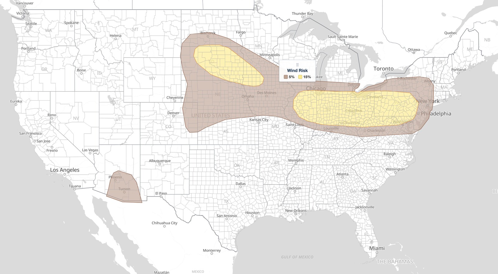
Midwest severe thunderstorms are the main weather story on Monday, August 10, 2026. The NOAA Storm Prediction Center issued its Day 1 Convective Outlook at 05:25 UTC placing a long corridor from northern Illinois through Indiana, Ohio, and Pennsylvania to Baltimore under a Slight Risk, the second of five severe categories (level 2 of 5). A separate Slight Risk covers the Dakotas. Damaging wind is the primary hazard, with a 15% damaging wind probability across the whole eastern corridor.
Key points:
- The Slight Risk for midwest severe thunderstorms covers Chicago, Indianapolis, Columbus, Cleveland, Cincinnati, Toledo, Dayton, Pittsburgh, Harrisburg, Allentown, Scranton, Baltimore, and Wilmington.
- Damaging wind is the lead hazard for midwest severe thunderstorms, at a 15% probability across that entire corridor from Chicago to Baltimore.
- A 2% tornado probability covers a narrower band: Chicago, Gary, South Bend, Fort Wayne, Toledo, Cleveland, Akron, Youngstown, Columbus, Dayton, and Pittsburgh. Indianapolis, Cincinnati, Harrisburg, and Baltimore are outside it.
- The 15% large hail probability is in the Dakotas only, over Pierre and Aberdeen. The eastern corridor carries 5% hail.
- The Dakotas Slight Risk also includes Watertown, Mitchell, and Sioux Falls, with a hatched conditional intensity area for hail.
- New York City, Philadelphia, Washington DC, Detroit, Buffalo, Albany, and Des Moines are outside the Slight Risk, in the Marginal Risk at 5% wind.
Where Midwest Severe Thunderstorms Are Most Likely
The eastern Slight Risk for midwest severe thunderstorms is a long narrow corridor. It begins over northern and central Illinois at Chicago, Joliet, Peoria, Springfield, and Champaign, runs east across Indiana through Gary, South Bend, Lafayette, Indianapolis, Terre Haute, and Fort Wayne, then covers essentially all of Ohio: Toledo, Lima, Dayton, Cincinnati, Columbus, Akron, Cleveland, and Youngstown.
From there it continues across Pennsylvania through Pittsburgh, State College, Williamsport, Harrisburg, York, Lancaster, Reading, Wilkes-Barre, Scranton, and Allentown, then reaches the northern Mid-Atlantic at Frederick, Hagerstown, Cumberland, and Baltimore in Maryland, Wilmington in Delaware, and Morgantown in West Virginia.
The eastern edge of the midwest severe thunderstorms risk area is where readers get caught out. Philadelphia, Washington DC, and New York City are not in the Slight Risk. Neither are Detroit, Buffalo, Rochester, Syracuse, Albany, Erie, Trenton, Newark, Louisville, Madison, or Des Moines. All of those sit in the surrounding Marginal Risk (level 1 of 5) at a 5% wind probability, where isolated severe storms remain possible. Milwaukee, Grand Rapids, St. Louis, Lexington, and Evansville are in the General Thunderstorm area only.
SPC uses a five-tier system to communicate severe weather potential. For a full explanation of how each level is defined, see SPC outlook risk categories explained. A Slight Risk for midwest severe thunderstorms means scattered severe storms are possible, not that a widespread outbreak is expected.
The Dakotas Slight Risk Carries the Hail
The second Slight Risk of the day sits well west of the midwest severe thunderstorms corridor, over the Dakotas and into eastern South Dakota, covering Pierre, Aberdeen, Watertown, Mitchell, and Sioux Falls. This is where the day’s highest hail probability lives: a 15% large hail probability over Pierre and Aberdeen. The eastern corridor from Chicago to Baltimore carries 5% hail, not 15%.
The SPC also draws a hatched conditional intensity area for hail across central and northeastern South Dakota, covering Pierre, Aberdeen, and Watertown. That marks where any storm that does form could reach the higher end of the hail threat. It is not the significant-severe hatching, and the discussion does not give a maximum stone size.
Rapid City, Bismarck, Dickinson, Jamestown, Omaha, Lincoln, North Platte, and Valentine are in the Marginal Risk. Fargo, Minot, Williston, Grand Forks, and Minneapolis are in the General Thunderstorm area only.
Meteorologist’s Take
The setup for today’s midwest severe thunderstorms starts aloft, and it is a subtle one, which is worth understanding before reading too much into the category. A belt of enhanced west to northwesterly flow is overspreading the northern Plains, the Midwest, and southern New England. The SPC is explicit that only modest height falls are forecast at best, which normally argues against a big day.
What makes it work anyway is a train of small features: several convectively enhanced vorticity maxima, compact spin-ups generated by earlier thunderstorm complexes, migrating through that flow. Each one focuses its own corridor of storm potential. That is why today’s midwest severe thunderstorms form a long stripe rather than one centre of action.
The SPC describes two rounds of midwest severe thunderstorms in the eastern corridor. Early-day storms crossing the Midwest this morning should stay sub-severe. By midday, convection could intensify over the upper Ohio Valley, Pennsylvania, and western New York, with clusters posing a damaging wind and hail risk in a moderately unstable air mass as they spread east toward the Mid-Atlantic.
The second round is the one to watch. Later in the afternoon another shortwave impulse spreads east from Illinois into Indiana and Ohio, into strong instability and rich boundary layer moisture. With modestly steep mid-level lapse rates and effective shear greater than 40 knots, the SPC expects initial supercells capable of large hail. As those cells cluster and bowing segments develop, the hazard shifts toward damaging wind, and a tornado or two could occur.
Note how tightly the tornado probability is drawn. The 2% area runs from Chicago east through northern Indiana and Ohio to Pittsburgh. Indianapolis, Cincinnati, Harrisburg, Allentown, and Baltimore are all in the Slight Risk for wind while sitting outside the tornado area. Wind is the story corridor-wide; the tornado caveat belongs to the northern half.
In the Dakotas the mechanism is different. Southeasterly low-level flow is pushing mid to upper 60s dewpoints northwest across South Dakota, with 70s dewpoints farther southeast into Nebraska, Iowa, and southern Minnesota, supporting strong to extreme instability. Coverage is uncertain, but most guidance develops at least isolated storms by evening, and elongated hodographs with favorable deep shear support supercells and bows capable of large hail and damaging wind. The escalation to watch for is overnight: if clustering occurs and a low-level jet develops, upscale growth into a bowing MCS could drive a swath of damaging wind across South Dakota into northwest Iowa.
How to Stay Safe During Midwest Severe Thunderstorms
Damaging wind is the top hazard with today’s midwest severe thunderstorms, so move vehicles away from trees and into a garage or carport before storms arrive this afternoon. Falling limbs and flying debris cause most injuries in non-tornadic severe thunderstorms, and a bowing line gives very little warning.
If a Severe Thunderstorm Warning is issued for your county, move indoors and away from windows. Between Chicago and Pittsburgh the 2% tornado probability means a tornado warning is possible too. If one is issued, go to the lowest interior room of a sturdy building, a basement or an interior hallway on the ground floor.
In the Dakotas, hail is the hazard to plan around, particularly near Pierre, Aberdeen, and Watertown, where the SPC carries its 15% hail probability and the conditional intensity area. Get vehicles under cover before evening. If the overnight bowing complex materializes across South Dakota into northwest Iowa, damaging wind becomes the greater concern after dark, which is when people are least likely to hear a warning.
Timing for midwest severe thunderstorms runs west to east through the day. Track live radar and active alerts on iAlert through the afternoon and evening so you can act the moment a warning is issued for your location, and check your local weather forecast for timing specific to your area.
Midwest Severe Thunderstorms FAQ
Which cities are in the Slight Risk for midwest severe thunderstorms today?
The eastern corridor includes Chicago, Joliet, Peoria, Springfield, Champaign, Gary, South Bend, Lafayette, Indianapolis, Fort Wayne, Toledo, Lima, Dayton, Cincinnati, Columbus, Akron, Cleveland, Youngstown, Pittsburgh, State College, Harrisburg, York, Lancaster, Reading, Scranton, Allentown, Baltimore, Frederick, and Wilmington. The Dakotas area includes Pierre, Aberdeen, Watertown, Mitchell, and Sioux Falls.
Are Philadelphia, Washington DC, and New York City in the midwest severe thunderstorms risk area?
No. All three are in the Marginal Risk (level 1 of 5) at a 5% wind probability, just outside the Slight Risk, along with Detroit, Buffalo, Albany, and Trenton. Isolated severe storms are still possible there. The Slight Risk stops at roughly Baltimore and Wilmington on its eastern end.
How large could hail get in today’s storms?
The SPC does not give a maximum hail size for today’s midwest severe thunderstorms. It places a 15% large hail probability over Pierre and Aberdeen in South Dakota, and adds a hatched conditional intensity area across central and northeastern South Dakota marking where the higher end of the hail threat is possible if storms develop. Across the Chicago to Baltimore corridor the hail probability is 5%.
Are tornadoes expected with today’s midwest severe thunderstorms?
A tornado or two could occur. The SPC draws a 2% tornado probability from Chicago east through northern Indiana and Ohio to Pittsburgh, including Gary, South Bend, Fort Wayne, Toledo, Cleveland, Akron, Youngstown, Columbus, and Dayton. No tornado probability is drawn over the Dakotas, eastern Pennsylvania, or Maryland.
When will the storms arrive?
Early-day storms crossing the Midwest this morning should stay below severe limits, so midwest severe thunderstorms are a midday-onward story. Convection could intensify by midday over the upper Ohio Valley, Pennsylvania, and western New York, with a second and stronger round developing later in the afternoon as an impulse spreads east from Illinois into Indiana and Ohio, continuing into the evening. In the Dakotas the main window is evening into the overnight.
Sources:
Get Severe Weather Alerts for Your Location
When any NWS watch, warning, or advisory is issued for your area, iAlert sends you an immediate notification by email, text message, or phone call, 24 hours a day, 7 days a week.
Sign Up for Severe Weather Alerts →

