
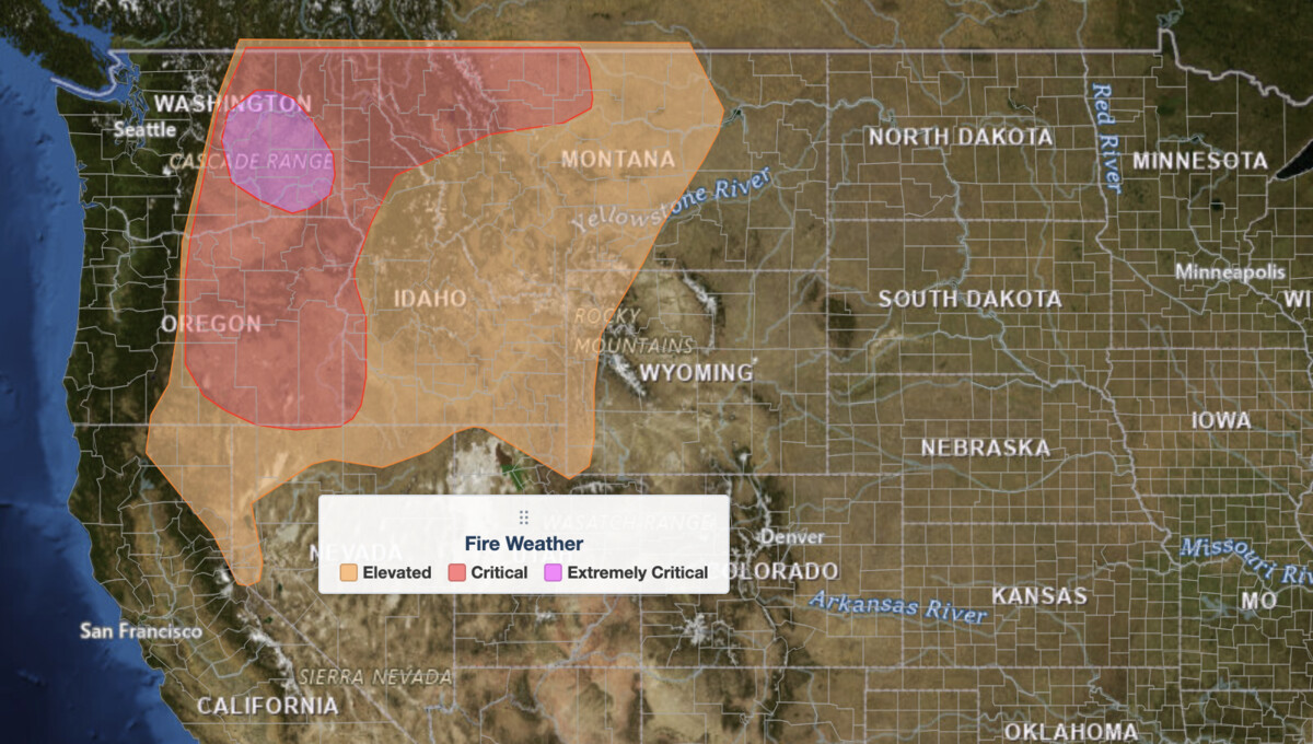
Extremely critical fire weather is forecast for the Columbia Basin of central and southeastern Washington on Saturday, August 1, 2026, after the Storm Prediction Center (SPC) upgraded its Day 2 Fire Weather Outlook to the highest of its three risk tiers. Sustained winds of 20 to 30 mph, gusts to 45 mph, humidity falling to 15 to 20 percent, and fuels near record dryness all arrive at once. Several large wildfires are already burning inside that zone.
Key points:
- SPC upgraded the Columbia Basin to extremely critical fire weather, tier 3 of 3, in the outlook issued 2:19 AM CDT July 31.
- Extremely Critical area: portions of the Columbia Basin in central and southeastern Washington.
- Critical area: eastern Oregon and far western Idaho into eastern Washington, the Idaho Panhandle, and northwestern to north-central Montana.
- Elevated area: much of the northern Great Basin, eastern Pacific Northwest, northern Rockies, and parts of the northern High Plains.
- Core-zone winds: sustained 20 to 30 mph, locally higher through terrain gaps, gusting 35 to 45+ mph.
- Humidity: 15 to 20 percent in the Columbia Basin, as low as 5 percent over southeastern Oregon and north-central Montana.
- Fuels: Energy Release Component at or above the 95th percentile. Large wildfires are already ongoing.
What Extremely Critical Fire Weather Means
The SPC Day 2 Fire Weather Outlook is a forward-looking product issued daily for the following day. It identifies where the atmosphere is primed to start and spread wildfires rapidly. Extremely critical fire weather is the top of its three-tier scale, above Elevated and Critical, and forecasters reserve it for days when wind, humidity, and fuel dryness all reach dangerous levels at once.
The fuel state is what separates this from a routine windy, dry day. SPC cites Energy Release Component values approaching or exceeding the 95th percentile across the Columbia Basin. Energy Release Component, or ERC, is a fuel-dryness index: a 95th-percentile reading means the vegetation is drier than on 95 percent of days in the historical record for this date. Dry fuel plus strong wind is what turns an ignition into a running fire.
Where the Extremely Critical Fire Weather Risk Sits
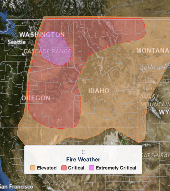
The extremely critical fire weather area covers portions of the Columbia Basin in central and southeastern Washington, east of the Cascade crest. The Yakima and Kittitas valleys, the Tri-Cities, and the Walla Walla area sit inside or near it.
The surrounding Critical area is much larger, running from eastern Oregon and far western Idaho into eastern Washington, up through the Idaho Panhandle, and across northwestern and north-central Montana. SPC forecasts sustained winds of 20 to 25 mph there against humidity as low as 5 percent, driest over southeastern Oregon and in the lee of the Rockies in north-central Montana, with ERC values commonly above the 90th to 98th percentile.
The Elevated area is broader still, taking in much of the northern Great Basin, the eastern Pacific Northwest, the northern Rockies, and parts of the northern High Plains. Winds there are lighter at 15 to 20 mph, but humidity still bottoms out between 5 and 20 percent over fuels in the 80th to 98th percentile for dryness. SPC also flags a separate pocket of pre-frontal southwesterly winds up to 20 mph across eastern Idaho Saturday afternoon that could turn locally critical.
Meteorologist’s Take
This is a textbook Northwest wind event. An upper-level ridge holds from the Desert Southwest into the northern High Plains while a potent upper trough comes onshore over the Pacific Northwest and British Columbia. A surface low amplifies over southern Alberta and drives a dry cold front rapidly east-southeastward. Underneath it, a tightening surface pressure gradient sits below a 35 to 45 knot jet at 700 millibars, roughly 10,000 feet, close enough to the surface to mix strong winds down through a dry boundary layer.
The Cascades do the rest. Air descending the lee side warms and dries as it sinks, which is why the Columbia Basin gets the deepest humidity crash in the region. That downslope component is the specific reason central Washington is the bullseye rather than eastern Oregon, where the pressure gradient is weaker even though the air is drier.
What pushes this into extremely critical fire weather is the fuel state combined with fires already burning. SPC explicitly cites ongoing large wildfires in the Columbia Basin. Those are not hypothetical ignitions. Existing fire perimeters exposed to 45 mph gusts and 15 percent humidity are the most likely source of rapid growth on Saturday.
Timing matters too. The front moves through quickly, so the worst conditions are a window rather than an all-day event, and wind direction shifts behind it. A wind shift on an active fire turns a long flank into a new head. That is when perimeters change fastest and evacuation orders come with the least notice.
How to Stay Safe in Extremely Critical Fire Weather
When extremely critical fire weather is in the forecast, the priority is avoiding new ignitions. Skip all outdoor burning, including campfires, debris piles, and burn barrels, even where locally permitted. Skip anything that throws sparks: chainsaws, grinders, welding, mowing or driving over dry grass, and dragging trailer chains are all documented ignition sources on days like this.
If you are near an ongoing fire in the Columbia Basin, treat Saturday as an active-threat day, not a monitoring day. Review your evacuation plan, keep a go-bag by the door, know two routes out of your neighborhood, and keep a phone charged and audible overnight. Track active alerts for your location on iAlert’s active weather alerts page and check the local weather forecast for hour-by-hour wind and humidity.
Do not wait for an official evacuation order before preparing to leave. In extremely critical fire weather, fires move faster than notification systems can always keep up with. Red flag warnings from your local National Weather Service office carry the precise timing for your county.
Extremely Critical Fire Weather FAQ
What does extremely critical fire weather mean?
Extremely Critical is the SPC’s highest fire weather risk tier, above Elevated and Critical. It signals that wind, humidity, and fuel dryness have all reached dangerous levels at the same time. Any ignition under these conditions can produce a rapidly spreading wildfire that is difficult to control.
Are wildfires already burning in the Extremely Critical area?
Yes. SPC notes in this outlook that a few large wildfires are already ongoing across the Columbia Basin. The outlook forecasts conditions rather than tracking fires, but here the dangerous conditions are arriving over ground that is already burning.
When is the risk window in effect?
The outlook is valid 12Z Saturday August 1 through 12Z Sunday August 2, 2026, which is 5:00 AM PDT Saturday to 5:00 AM PDT Sunday. It was issued at 2:19 AM CDT on July 31. Conditions vary by hour, so monitor local National Weather Service red flag warnings for precise timing.
Which areas face the greatest danger?
The extremely critical fire weather core covers portions of the Columbia Basin in central and southeastern Washington. Critical risk surrounds it across eastern Oregon, far western Idaho, eastern Washington, the Idaho Panhandle, and northwestern to north-central Montana. Elevated risk extends into the northern Great Basin and northern High Plains. See the iAlert live radar and alerts map for the exact footprint of each tier.
How rare is this designation?
Extremely critical fire weather is the least-used category on the SPC scale. Most fire weather outlooks top out at Elevated or Critical. An upgrade on a Day 2 product gives land managers and emergency responders roughly 24 to 36 hours to position crews and equipment before the threat window opens.
Sources:
Get Severe Weather Alerts for Your Location
When any NWS watch, warning, or advisory is issued for your area, iAlert sends you an immediate notification by email, text message, or phone call, 24 hours a day, 7 days a week.
Sign Up for Severe Weather Alerts →

