
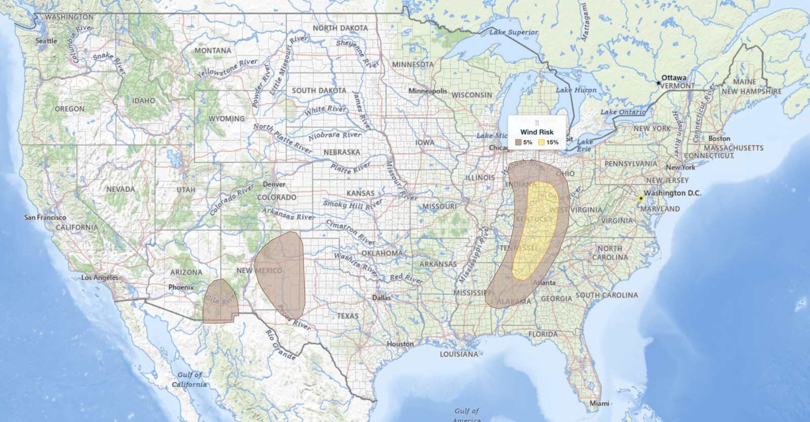
Ohio Valley severe thunderstorms are the primary concern for August 1, 2026, as the NOAA Storm Prediction Center has issued a Slight Risk outlook across parts of the Ohio and Tennessee Valleys. The risk corridor starts at the Ohio River near Cincinnati and Dayton and runs south through central and eastern Kentucky, across the Cumberland Plateau of Tennessee, and into far northeast Alabama and northwest Georgia. Damaging wind gusts and an isolated tornado are the hazards this afternoon and evening.
SPC uses a five-tier system to communicate severe weather potential, and you can explore how each SPC outlook risk category works for more detail. The Slight Risk is the second of five severe categories (level 2 of 5).
Key points:
- A Slight Risk (level 2 of 5) runs from southwest Ohio and far southeast Indiana south through Kentucky into east-central Tennessee, far northeast Alabama, and far northwest Georgia on August 1, 2026.
- Cities inside the Slight Risk include Cincinnati, Dayton, Lexington, Frankfort, Somerset, Cookeville, Crossville, Chattanooga, Huntsville, and Dalton.
- Damaging wind gusts are the primary hazard. The SPC 15% damaging wind area covers the same ground as the Slight Risk.
- An isolated tornado threat exists, mainly with discrete supercells in the early afternoon. The SPC tornado probability is 2% and the large hail probability is 5%.
- Louisville, Nashville, Knoxville, Indianapolis, and Columbus sit just outside, in the surrounding Marginal Risk (level 1 of 5), where isolated severe storms are still possible.
- Storms are expected to organize into a broken line by mid to late afternoon and move east toward the southern Appalachians.
Where Ohio Valley Severe Thunderstorms Are Expected Today
The Slight Risk is a long, narrow corridor rather than a broad blanket. It begins along the Ohio River near Cincinnati and Dayton, takes in far southeast Indiana around Madison and Lawrenceburg, then bends south-southwest across central and eastern Kentucky through Frankfort, Lexington, and Somerset. From there it follows the Cumberland Plateau across east-central Tennessee, covering Cookeville, Crossville, and Chattanooga, and ends over far northeast Alabama near Huntsville and far northwest Georgia near Dalton.
That southern reach matters. The Ohio Valley label describes the northern third of this outlook. Most of the ground covered by today’s Ohio Valley severe thunderstorms sits south of the Ohio River, which is why the SPC headline names both the Ohio and Tennessee Valleys. If you are in Chattanooga or Huntsville, this forecast is about you, not just about Kentucky and Ohio.
Several large metros fall just outside the Slight Risk boundary and inside the surrounding Marginal Risk: Louisville, Nashville, Knoxville, Indianapolis, and Columbus. A Marginal Risk still means isolated severe storms are possible. Do not read the outlook boundary as a wall.
Ahead of an advancing cold front, surface dewpoints are running through the 70s F across the moist sector. That rich low-level moisture is the fuel these storms need. MLCAPE values, a measure of how energetically air parcels can rise, are forecast to peak between 1,500 and 2,500 J/kg during the afternoon along the instability axis, which the SPC describes as running from eastern Tennessee northward into far southeast Indiana. Those are solidly moderate instability values and are more than sufficient to support organized severe storms when combined with the wind shear in place today.
Isolated severe wind gusts are also possible well to the west, in the southern High Plains, the southern Rockies, and from southeast Arizona into southwest New Mexico. The organized severe threat today, though, belongs to the Ohio and Tennessee Valleys.
Meteorologist’s Take
The atmospheric setup driving today’s Ohio Valley severe thunderstorms begins with a positively-tilted mid-level trough swinging southeastward across the mid Mississippi Valley. A positively-tilted trough is generally less aggressive than a negatively-tilted one, which helps explain why this event sits at a Slight rather than a higher risk level. The associated cold front pushing eastward into the Ohio and Tennessee Valleys acts as the surface trigger, with low-level convergence along the frontal boundary helping to fire scattered to widespread convection this afternoon.
Wind shear is the other key ingredient. The SPC notes that 850-millibar wind speeds are expected to increase to around 30 knots along a low-level speed maximum, and 0-3 km storm-relative helicity is forecast to reach around 200 m²/s². Those helicity values are meaningful: enough rotational energy exists in the lower atmosphere to support an isolated tornado from any supercell that stays discrete in the early afternoon before storms consolidate.
One detail in the outlook is worth calling out. The Slight Risk polygon and the 15% damaging wind polygon are the same shape today. That is the SPC saying the wind threat alone is what earned the upgrade, with the 2% tornado and 5% hail probabilities riding along inside it. When those two areas match, the message is straightforward: plan for a wind event that could produce a tornado, not a tornado event that also brings wind.
The SPC expects storm mode to transition from discrete cells to a broken line by mid to late afternoon, shifting the primary hazard from tornadoes to organized damaging wind gusts, with that threat persisting into the early evening hours as the line moves east.
How to Stay Safe During Ohio Valley Severe Thunderstorms
Because damaging wind is the leading hazard in today’s Ohio Valley severe thunderstorms, your first priority is getting indoors and away from windows before storms arrive. Wind gusts from an organized line can bring down trees and power lines with little warning. Stay clear of any large trees or unsecured outdoor objects that could become projectiles.
The isolated tornado threat in the early afternoon hours is real, even at low probability. If a tornado warning is issued for your county, move immediately to an interior room on the lowest floor of a sturdy building, away from windows. Keep a weather alert feed active on your phone throughout the afternoon so you can act quickly when warnings are issued.
Timing for today’s Ohio Valley severe thunderstorms runs roughly north to south. Storms fire first near Cincinnati, Dayton, and northern Kentucky during the early afternoon, then build south into Tennessee. If you are in Chattanooga, Huntsville, or northwest Georgia, your window comes later in the afternoon and into the evening as the line consolidates and moves toward the southern Appalachians.
Monitor live radar as the line organizes this afternoon. You can track the storm progression with iAlert’s live radar and alerts tool to know exactly when the threat reaches your location.
Ohio Valley Severe Thunderstorms FAQ
Where is the highest risk for Ohio Valley severe thunderstorms today?
The Slight Risk corridor runs from Cincinnati, Dayton, and far southeast Indiana south through central and eastern Kentucky, across the Cumberland Plateau of Tennessee to Chattanooga, and into far northeast Alabama and far northwest Georgia. That corridor carries the greatest potential for both discrete supercells in the early afternoon and an organized line later in the day.
Are Louisville, Nashville, and Knoxville in the Slight Risk?
No. All three sit just outside the Slight Risk area for today’s Ohio Valley severe thunderstorms, in the surrounding Marginal Risk (level 1 of 5), along with Indianapolis and Columbus. Isolated severe storms are still possible in a Marginal Risk, and outlook boundaries shift with each SPC update, so treat the edge as approximate rather than exact.
How strong could wind gusts be with these storms?
The SPC assigns a 15% damaging wind probability across the Slight Risk area. That probability reflects the chance of a damaging wind report within 25 miles of any point, not a specific gust speed. Organized squall lines in setups like this are capable of producing gusts that down trees and damage structures.
Are tornadoes expected with today’s Ohio Valley severe thunderstorms?
An isolated tornado is possible, primarily with any supercell that stays discrete during the early afternoon. The SPC places the tornado probability at 2%. The tornado threat diminishes later in the day as storms consolidate into a line.
When will storms arrive and how long will the threat last?
Convection is expected to develop in the Ohio Valley during the early afternoon, spread southward into the Tennessee Valley, and organize into a broken line by mid to late afternoon. The severe wind threat from any organized line persists into the early evening hours.
Sources:
Get Severe Weather Alerts for Your Location
When any NWS watch, warning, or advisory is issued for your area, iAlert sends you an immediate notification by email, text message, or phone call, 24 hours a day, 7 days a week.
Sign Up for Severe Weather Alerts →

