
Ozarks severe thunderstorms are the headline hazard for July 31, 2026, as the NOAA Storm Prediction Center has issued a Slight Risk covering parts of the Ozarks and mid Mississippi Valley, with damaging wind gusts and hail expected this afternoon and into the early to mid evening. A secondary threat of isolated severe wind gusts extends into parts of the southern Plains and from east-central Colorado into northeastern New Mexico.
Key points:
- Slight Risk (level 2 of 5) covers the Ozarks and mid Mississippi Valley for July 31.
- Main hazards are severe wind gusts and hail; isolated severe gusts also possible in the southern Plains and east-central Colorado into northeastern New Mexico.
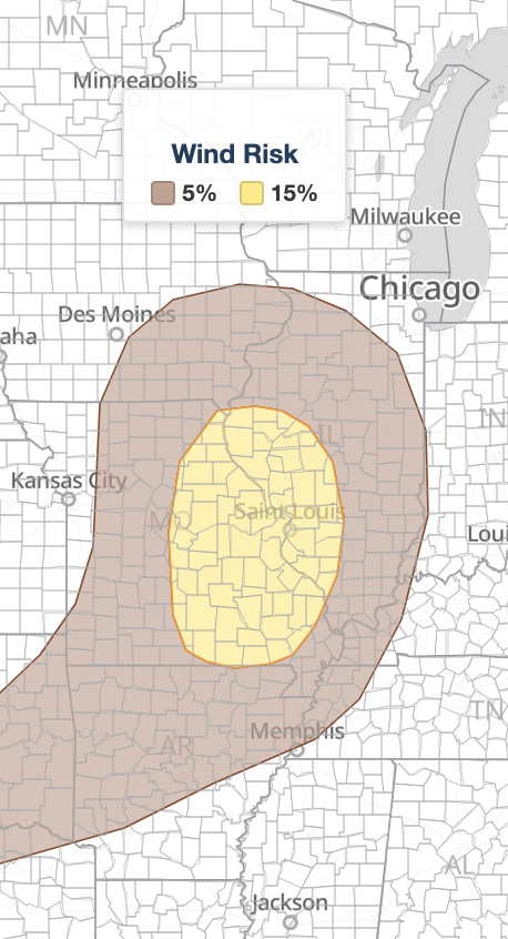
- SPC places the damaging wind probability at 15%, large hail at 5%, and tornado probability at 2%.
- Storms expected to develop this afternoon and persist into the early to mid evening.
- Storm mode includes supercells and organized line segments across the primary risk area.
Where and When Ozarks Severe Thunderstorms Are Expected
The SPC identifies the western Ozarks as the focal point for storm initiation, with a cold front pushing southeastward into that area ahead of a positively tilted shortwave trough dropping through the mid to upper Mississippi Valley. Surface dewpoints in the 70s°F will fuel an axis of rich moisture ahead of the front, allowing moderate to strong instability to build by afternoon. The SPC forecasts mixed-layer CAPE values peaking between 2,500 and 3,500 J/kg during peak heating hours.
The primary Ozarks severe thunderstorms risk area runs from southern Missouri northeast across central and southern Illinois, taking in the St. Louis metro. Once storms fire, they are expected to track southeastward across the mid Mississippi Valley, and the threat could linger into the early to mid evening.
The second area of concern spans parts of the southern Plains, with a cold front dropping southward into central Oklahoma and the Texas Panhandle by afternoon. Scattered storms in that region will move south-southeastward across the Red River Valley and southward across the Caprock of west Texas, with a separate cluster of isolated severe wind producers possible from east-central Colorado into northeastern New Mexico.
Meteorologist’s Take
The atmospheric setup driving Ozarks severe thunderstorms today centers on two ingredients working together: strong instability and meaningful wind shear. Mid-level flow running westerly at 30 to 35 knots provides enough deep-layer shear for organized storm structures. That shear, combined with 0–3 km lapse rates peaking near 7°C/km, creates the steep low-level temperature drop with height that supercharges downdraft winds. In plain terms, air cooling very rapidly as it descends will hit the surface as damaging outflow gusts, making wind the primary concern over hail or tornadoes.
The mixed storm mode, supercells alongside organized line segments, matters because each produces wind damage in a different way. Supercells can drop brief large hail and focused damaging gusts along a narrow path. Linear segments spread straight-line wind damage across a much broader swath, which is how a single storm complex can rack up dozens of reports in one evening.
In the southern Plains and the Colorado and New Mexico zone, temperature-dewpoint spreads exceeding 40°F in some locations mean precipitation will evaporate heavily on the way down. That evaporation cools the air, makes it denser, and accelerates the downdraft, a process forecasters call evaporative cooling. It is why a storm that looks unimpressive on radar out there can still deliver a 60 mph gust at the surface.
SPC uses a five-tier system to communicate severe weather potential. Today’s Slight Risk is the second of those five categories (level 2 of 5), indicating scattered severe storm potential rather than a widespread or extreme outbreak. You can read how each SPC outlook risk category is defined for a closer look at what a Slight Risk means operationally. Residents across the risk zone should still take Ozarks severe thunderstorms at this category seriously, because level 2 of 5 produces destructive localized wind damage every season.
How to Stay Safe During Ozarks Severe Thunderstorms
Because damaging wind is the lead hazard in today’s Ozarks severe thunderstorms, your first priority is getting indoors ahead of any approaching storm. Secure or bring inside loose outdoor furniture, canopies, and any lightweight objects that wind could turn into projectiles. Avoid parking under large trees, which are the most common source of wind-related damage and injury during convective events like this one.
If hail accompanies a storm cell, move vehicles into a garage or covered structure before storms arrive rather than after. Keep a weather app or active weather alerts open on your phone so you receive any Severe Thunderstorm Warning the moment it is issued for your county.
Have a plan to move to an interior room on the lowest floor of a sturdy building if a warning is issued. That position offers the best protection from both wind damage and any brief spin-up. Mobile homes and vehicles are not safe shelter from 60 to 70 mph straight-line winds.
Ozarks Severe Thunderstorms FAQ
Where is the highest severe weather risk on July 31, 2026?
The SPC places the highest risk in the Ozarks and mid Mississippi Valley under a Slight Risk, level 2 of 5. Secondary isolated severe wind potential exists in parts of the southern Plains and from east-central Colorado into northeastern New Mexico.
How strong could wind gusts get?
The SPC does not specify an exact peak gust speed in today’s discussion, but a 15% damaging wind probability applies within the Slight Risk area, meaning there is a 15% chance of a damaging wind report within 25 miles of any point in that zone.
How large could the hail get with today’s Ozarks severe thunderstorms?
Hail is possible but secondary. The SPC sets the large hail probability at 5% for this outlook, where “large” means one inch in diameter or greater. Supercells could produce hail at or above that threshold, but wind is the dominant hazard today.
Is there a tornado threat with today’s Ozarks severe thunderstorms?
The tornado threat is low. SPC carries a 2% tornado probability, the lowest contoured level, which reflects the chance of a brief spin-up within a supercell or along an organized line rather than a meaningful tornado event.
When will storms develop and move through?
Storms are expected to develop this afternoon as surface heating peaks, then track southeastward across the mid Mississippi Valley with the threat persisting into the early to mid evening hours.
Sources:
Get iAlert Notifications for Your Location
The moment a threat is issued for your area, iAlert sends an immediate alert by email, text message, or phone call, 24/7. Choose the alerts you need:
Severe Weather Alerts → ⚡ Lightning Detection Alerts →

