
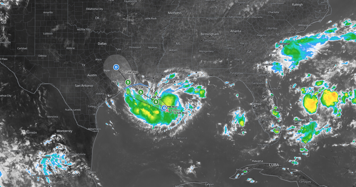
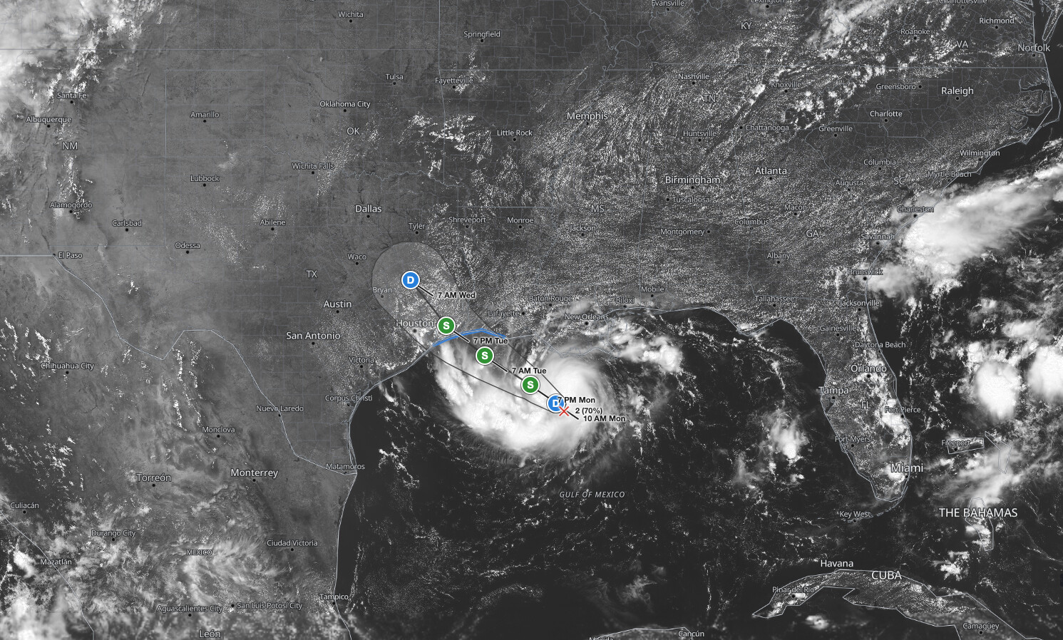
Gulf Coast tropical storm conditions are expected to arrive as early as Tuesday, September 1, 2026, as Potential Tropical Cyclone Five moves west-northwest toward the upper Texas and southwestern Louisiana coast with an 80 percent formation chance through 48 hours. The National Hurricane Center issued a Tropical Storm Warning at 10 AM CDT Monday, August 31, covering the northwestern Gulf Coast from Port Bolivar, Texas, to the Vermilion/Cameron Parish Line in Louisiana, and the Weather Prediction Center has placed portions of the region under a Moderate risk for excessive rainfall.
Key points:
- Tropical Storm Warning in effect from Port Bolivar, TX to the Vermilion/Cameron Parish Line, LA.
- System forecast to become a tropical storm by tonight; landfall expected Tuesday.
- Storm surge of 1 to 3 ft possible from High Island, TX to the Vermilion/Iberia Parish Line, LA.
- Rainfall of 3 to 6 inches, with isolated totals up to 9 inches, expected across the upper Texas coast.
- WPC has issued a Moderate (level 3 of 4) excessive rainfall risk for the Day 1 period ending 12Z September 1.
Get Severe Weather Alerts for Your Location
When any NWS watch, warning, or advisory is issued for your area, iAlert sends you an immediate notification by email, text message, or phone call, 24 hours a day, 7 days a week.
Sign Up for Severe Weather Alerts →What the Gulf Coast Tropical Storm Warning Covers
As of 10 AM CDT Monday, the center of Potential Tropical Cyclone Five was located near 27.8°N, 91.0°W, about 130 miles south of Morgan City, Louisiana, and roughly 230 miles southeast of Port Arthur, Texas. Maximum sustained winds were near 35 mph with higher gusts, and the minimum central pressure was 1013 mb.
The system was moving west-northwest near 5 mph, and the NHC expects that general motion to continue for the next day or two. The Tropical Storm Warning signals that tropical storm conditions are expected somewhere within the warning zone within 36 hours.
NWS Houston/Galveston issued a separate marine warning covering coastal waters from High Island to Freeport, Texas, out to 60 nautical miles, valid until 9 AM CDT Wednesday, with winds of 20 to 25 knots and gusts up to 40 knots and seas of 3 to 5 feet.
NWS Lake Charles issued a parallel marine warning for portions of Louisiana’s coastal lakes and bays, noting southeast winds of 20 to 35 knots with gusts up to 45 knots near the center and seas of 4 to 8 feet. Both offices warn that tropical storm force winds and hazardous seas will capsize or damage vessels and reduce visibility.
Storm Surge, Rainfall, and Flash Flood Threat From the Gulf Coast Tropical Storm
The NHC advisory warns that the combination of storm surge and tide will cause normally dry areas near the coast to flood by rising waters moving inland from this Gulf Coast tropical storm. Peak surge of 1 to 3 feet above ground level is possible from High Island, Texas, to the Vermilion/Iberia Parish Line in Louisiana, with the deepest water expected along the immediate coast near and to the east of the center. Surge heights can vary greatly over short distances depending on the relative timing of the surge and the tidal cycle.
On the rainfall side, the Gulf Coast tropical storm is forecast to produce 3 to 6 inches of rain over the upper Texas coast inland through east-central Texas, with isolated maximum totals of up to 9 inches. Southwest Louisiana can expect 2 to 3 inches. The WPC’s Day 1 Excessive Rainfall Outlook, covering the period from 16Z August 31 through 12Z September 1, places the area under a Moderate risk, which is level 3 of 4, indicating a meaningful probability that rainfall will exceed local flash-flood guidance. Flash flooding is particularly likely in low-lying and urban areas.
Meteorologist’s Take
Systems classified as potential tropical cyclones have already met the wind threshold for tropical storm status or are expected to reach it quickly; the NHC issues full advisories and warnings for them precisely so coastal communities have the lead time they would get from a named storm. The 80 percent formation probability the NHC assigned to this Gulf Coast tropical storm reflects high confidence that a closed warm-core circulation will develop before or shortly after landfall.
The rainfall threat deserves close attention independent of the wind hazard. Slow-moving tropical systems interacting with the warm, shallow waters of the northwestern Gulf of Mexico can produce training convection, where repeated bands of rain fall over the same locations. That mechanism is what drives isolated totals well above the 3 to 6 inch forecast range, and it is why the WPC elevated the excessive rainfall risk to Moderate for this Gulf Coast tropical storm event. Urban drainage systems along the upper Texas coast can become overwhelmed quickly under these conditions.
Marine interests across the northwestern Gulf should treat this Gulf Coast tropical storm as they would a named storm; a developing system can expand its outer wind field rapidly as it approaches shore. Conditions will deteriorate quickly once the outer wind field moves onshore, and seas of 4 to 8 feet near the center make small vessel operations extremely hazardous.
How to Stay Safe During the Gulf Coast Tropical Storm
Residents in the Tropical Storm Warning zone should complete all outdoor preparations before tropical storm conditions arrive on Tuesday. Outdoor furniture, signage, and loose items can become projectiles in 35 to 45 mph gusts. Avoid unnecessary travel through low-lying or flood-prone roads once rain from the Gulf Coast tropical storm begins, as even shallow moving water can carry a vehicle off the road. If local officials issue an evacuation order for coastal areas at risk of storm surge from the Gulf Coast tropical storm, leave early rather than waiting for conditions to deteriorate.
Boaters should return to port immediately and keep vessels secured until the warning is lifted. Check the latest active weather alerts on iAlert for real-time NWS products covering your specific county or marine zone, and monitor your local NWS forecast office for any inland watches or warnings that may be added as the system approaches. You can also track conditions with live radar and alerts on iAlert.
Gulf Coast Tropical Storm FAQ
When will tropical storm conditions arrive along the coast?
Tropical storm conditions are expected to reach the warning area on Tuesday, September 1, according to the NHC advisory. The warning covers Port Bolivar, TX to the Vermilion/Cameron Parish Line, LA.
How much storm surge is forecast?
Storm surge of 1 to 3 feet above ground level is possible from High Island, TX to the Vermilion/Iberia Parish Line, LA, if peak surge coincides with high tide. Surge heights vary greatly over short distances.
How much rain could this system produce?
The NHC forecasts 3 to 6 inches of rain over the upper Texas coast and east-central Texas, with isolated totals up to 9 inches. Southwest Louisiana could see 2 to 3 inches.
Is this a hurricane or a tropical storm?
As of the 10 AM CDT Monday advisory, the system is a potential tropical cyclone with 35 mph sustained winds. The NHC expects it to reach tropical storm status by tonight, with an 80 percent formation probability through 48 hours.
Sources:
- NOAA National Hurricane Center: Potential Tropical Cyclone Five Advisory Number 1, 10 AM CDT August 31, 2026
- NWS Lake Charles LA: Tropical Storm Warning for Louisiana Coastal Waters, August 31, 2026
- NWS Houston/Galveston TX: Tropical Storm Warning for Texas Coastal Waters, August 31, 2026
- NOAA Weather Prediction Center: Day 1 Excessive Rainfall Outlook, August 31, 2026
Get Severe Weather Alerts for Your Location
When any NWS watch, warning, or advisory is issued for your area, iAlert sends you an immediate notification by email, text message, or phone call, 24 hours a day, 7 days a week.
Sign Up for Severe Weather Alerts →

