
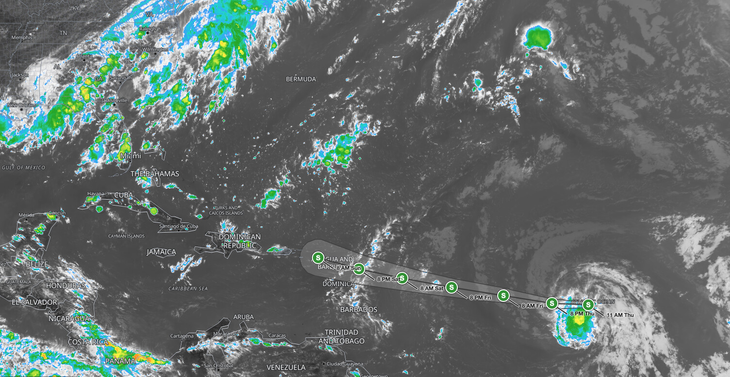
Tropical Storm Dolly formed over the central tropical Atlantic on Thursday, August 27, 2026, with maximum sustained winds of 40 mph and a westward track aimed at the Leeward Islands by this weekend, prompting the National Hurricane Center to advise interests in that region to monitor its progress closely.
Key points:
- Tropical Storm Dolly has 40 mph maximum sustained winds as of 11 AM AST Thursday.
- Dolly is located about 1,555 miles east of the Leeward Islands.
- No coastal watches or warnings are currently in effect.
- NHC forecasts Dolly to degenerate into a tropical wave before reaching the Leeward Islands.
- Heavy rain threatening flash flooding is expected in the Leeward Islands late Saturday into Sunday, and in the Virgin Islands, Puerto Rico, and Hispaniola Sunday and Monday.
Get Severe Weather Alerts for Your Location
When any NWS watch, warning, or advisory is issued for your area, iAlert sends you an immediate notification by email, text message, or phone call, 24 hours a day, 7 days a week.
Sign Up for Severe Weather Alerts →Tropical Storm Dolly: Formation and Current Status
Tropical Storm Dolly became the fourth named storm of the 2026 Atlantic hurricane season when the National Hurricane Center issued Advisory Number 1 at 11 AM AST on August 27. At that time, the storm was centered near latitude 13.6°N, longitude 38.7°W, roughly 1,555 miles east of the Leeward Islands, according to the NHC advisory.
The storm is moving westward near 24 mph, a motion expected to continue for the next couple of days. Tropical-storm-force winds extend outward up to 60 miles from the center, and the minimum central pressure stands at 1007 mb. The system is not fully organized: NHC notes that northwesterly wind shear already has most of the thunderstorm activity displaced to the southern side of the circulation, away from the center. The official forecast tops out at 45 mph over the next 48 hours, with little change in strength expected overall.
The NHC expects Tropical Storm Dolly to degenerate into a tropical wave before it reaches the Leeward Islands, and is carrying post-tropical forecast positions through Sunday because of the continued risk of gusty winds and heavy rain. Even as a tropical wave, the system’s moisture and energy can still produce significant rainfall across island communities in its path.
Rainfall and Flash Flooding Threat From Tropical Storm Dolly
Even though Tropical Storm Dolly is forecast to weaken, the associated heavy rain remains the primary hazard. The NHC advisory notes that heavy rain could begin affecting the Leeward Islands late Saturday into Sunday. The Virgin Islands, Puerto Rico, and Hispaniola are in line for heavy rain Sunday and Monday.
Flash flooding is a specific concern, particularly in areas of higher terrain. Mountainous islands like Puerto Rico and Hispaniola channel rainfall into steep watersheds, where water rises rapidly with very little warning. Residents and visitors in those areas should pay close attention to local emergency management guidance as the system approaches.
You can track active advisories and alerts tied to Tropical Storm Dolly through iAlert’s active weather alerts page, which aggregates NHC and NWS products in real time.
Meteorologist’s Take
Tropical Storm Dolly is moving fast, 24 mph, steered by a strong ridge of high pressure over the central Atlantic. NHC’s forecast discussion lays out three reasons the environment turns hostile by Friday: increasing southwesterly wind shear from an upper-level trough over the central Atlantic, that fast forward motion itself, and dry air aloft. Every model NHC uses shows Dolly opening up into a strong tropical wave before it reaches the Leeward Islands, and the forecasters agree.
However, even degenerated tropical systems carry deep moisture, and that moisture does not disappear when the circulation breaks down. A tropical wave moving at 24 mph can still drop several inches of rain in a short window, which is more than enough to trigger flash flooding in terrain-heavy islands. Forecasters and emergency managers in the Leeward Islands, Virgin Islands, Puerto Rico, and Hispaniola are right to monitor Tropical Storm Dolly closely regardless of the anticipated weakening trend.
The 2026 Atlantic hurricane season is now tracking into its historically most active period. Dolly’s formation as the fourth named storm by late August underscores the importance of having a preparedness plan in place well before any individual system threatens. Check your local weather forecast regularly and sign up for alerts if you are in or traveling to the Caribbean region.
How to Stay Safe During Tropical Storm Dolly
If you are in the Leeward Islands, Virgin Islands, Puerto Rico, or Hispaniola, begin monitoring NHC updates now. Flash flooding can develop quickly, especially in higher terrain, so know your local flood evacuation routes before rain begins. Move to higher ground at the first sign of rising water; do not attempt to walk or drive through flooded areas.
Even without a direct tropical storm strike, heavy rainfall from Tropical Storm Dolly can overwhelm drainage systems and cause dangerous street flooding in low-lying coastal areas. Keep an emergency kit ready and stay tuned to local emergency management officials for guidance specific to your community.
Tropical Storm Dolly FAQ
Where is Tropical Storm Dolly right now?
As of 11 AM AST on August 27, 2026, Tropical Storm Dolly is centered near 13.6°N, 38.7°W, about 1,555 miles east of the Leeward Islands, moving west at 24 mph.
Will Tropical Storm Dolly make landfall as a tropical storm?
The NHC forecasts Tropical Storm Dolly to degenerate into a tropical wave before reaching the Leeward Islands. No coastal watches or warnings are currently in effect.
What hazards should the Leeward Islands and Puerto Rico expect?
Heavy rain is the main threat. The Leeward Islands could see heavy rain late Saturday into Sunday, while the Virgin Islands, Puerto Rico, and Hispaniola are at risk Sunday and Monday, with flash flooding possible in higher terrain.
How strong are Tropical Storm Dolly’s winds?
Maximum sustained winds are 40 mph as of the first advisory, with higher gusts. Tropical-storm-force winds extend up to 60 miles from the center. NHC forecasts a peak near 45 mph, with little change in strength over the next 48 hours.
Sources:
- NOAA National Hurricane Center, Tropical Storm Dolly Advisory Number 1, August 27, 2026
- NOAA National Hurricane Center, Tropical Storm Dolly Discussion Number 1, August 27, 2026
Get Severe Weather Alerts for Your Location
When any NWS watch, warning, or advisory is issued for your area, iAlert sends you an immediate notification by email, text message, or phone call, 24 hours a day, 7 days a week.
Sign Up for Severe Weather Alerts →

