
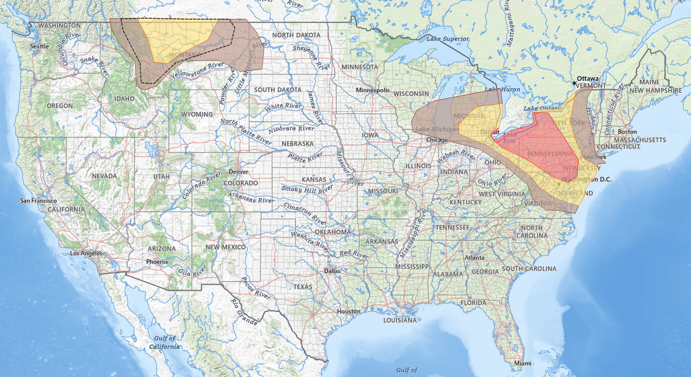
Great Lakes Mid-Atlantic severe thunderstorms are the main weather story for September 2, 2026. In its 05:57 UTC (1:57 am EDT / 12:57 am CDT) Day 1 outlook, the NOAA Storm Prediction Center drew a Slight Risk (level 2 of 5) from Detroit and Cleveland through Buffalo, Pittsburgh, Philadelphia, Baltimore, and Washington D.C., with damaging wind gusts as the primary hazard and large hail and a few tornadoes also possible today and tonight. A separate Slight Risk covers Great Falls, Montana, where the SPC expects scattered severe gusts with peak intensity of 65 to 80 mph.
Key points:
- Slight Risk (level 2 of 5) covers the Great Lakes Mid-Atlantic severe corridor from Detroit to Washington D.C., plus a second Slight Risk over Great Falls, Montana. Issued 05:57 UTC (1:57 am EDT / 12:57 am CDT), valid through 12Z (8:00 am EDT / 7:00 am CDT) September 3.
- Damaging wind is the lead hazard: a 30% wind probability covers 57,691 square miles and 14.7 million people from Cleveland and Buffalo across Pennsylvania to Baltimore.
- A 2% tornado probability covers Washington D.C., Detroit, Baltimore, Cleveland, Buffalo, and Rochester; the tornado risk may increase this evening over southern New York and central Pennsylvania.
- A 15% large hail probability covers Detroit, Cleveland, Pittsburgh, Buffalo, Rochester, and Syracuse.
- Montana storms could produce 65 to 80 mph gusts; a hatched Intensity Level 1 wind outline covers Great Falls, Helena, Butte, Kalispell, and Havre.
Get Severe Weather Alerts for Your Location
When any NWS watch, warning, or advisory is issued for your area, iAlert sends you an immediate notification by email, text message, or phone call, 24 hours a day, 7 days a week.
Sign Up for Severe Weather Alerts →Great Lakes Mid-Atlantic Severe Thunderstorms: Where the Highest Risks Sit
The SPC places the highest Great Lakes Mid-Atlantic severe wind threat, a 30% damaging wind probability, in a corridor from northeast Ohio and the Lake Erie shore across central and eastern Pennsylvania to northern Maryland and Delaware. Cities inside the 30% area include Baltimore, Cleveland, Buffalo, Allentown, Harrisburg, Wilmington, Youngstown, Hagerstown, Frederick, York, Lancaster, Reading, Erie, State College, Williamsport, and Chambersburg. The SPC summary puts the 30% area at 57,691 square miles and 14.7 million people.
Rochester, New York, sits less than a mile outside the 30% line, and the SPC summary lists it among the 30% cities, so treat Rochester as a 30% wind city. A broader 15% damaging wind probability covers Philadelphia, Washington D.C., Detroit, Pittsburgh, Toledo, Syracuse, Scranton, Trenton, Annapolis, Akron, Lansing, Flint, and Binghamton. The eastern Slight Risk outline follows that 15% wind line almost exactly, which tells you the wind threat alone earned the category. Every city in a severe risk area today carries some damaging wind probability.
The Great Lakes Mid-Atlantic severe hail picture is more focused. A 15% large hail probability covers Detroit, Cleveland, Pittsburgh, Buffalo, Rochester, Syracuse, Harrisburg, Akron, Youngstown, Flint, Saginaw, Ann Arbor, Hagerstown, Frederick, Binghamton, York, and Erie. Philadelphia, Washington D.C., Baltimore, Toledo, Allentown, Scranton, Wilmington, Annapolis, Lancaster, and Reading sit at a lower 5% large hail probability.
Six cities inside a severe risk area carry no large hail probability at all: Richmond, Charlottesville, Elkins, Rockford, Missoula, and Great Falls. For those cities, damaging wind is the only hazard the SPC has outlined.
The Great Lakes Mid-Atlantic severe tornado probability is narrower still. A 2% tornado probability covers 88,351 square miles and 26.5 million people, including Washington D.C., Detroit, Baltimore, Cleveland, Buffalo, Rochester, Harrisburg, Wilmington, Annapolis, Youngstown, Flint, Saginaw, Hagerstown, Frederick, Winchester, Leesburg, Arlington, York, Lancaster, Reading, and Erie. Philadelphia, Pittsburgh, Toledo, Syracuse, Allentown, Scranton, and Trenton are inside the Slight Risk but outside the tornado outline, so for those cities the outlined hazards are wind and hail.
A Marginal Risk, the first of five SPC severe categories, surrounds the Slight Risk in three separate pieces. The New York City metro, including Newark and Paterson, sits in Marginal territory with a 5% damaging wind and a 5% large hail probability. A second Marginal area covers Milwaukee, Madison, Kenosha, Rockford, Grand Rapids, Morgantown, Elkins, Richmond, and Charlottesville, and a third covers Williston, North Dakota, and Missoula, Montana. SPC uses a five-tier system to communicate severe weather potential; see the iAlert guide to SPC outlook risk categories for how each level is defined.
Montana Severe Thunderstorms: Great Falls in the Crosshairs
The Great Falls area holds its own Slight Risk, driven by a compact but strong shortwave trough the SPC expects to move rapidly northeastward from the Great Basin into the northern Rockies today and tonight. Mid-level flow of 35 to 50 kt will overspread a modestly moist but warm and unstable air mass across central and eastern Montana, and storms should develop over the higher terrain of western Montana through the afternoon.
Steep lapse rates and a deep, well-mixed boundary layer will enhance the severe wind gust potential, and 30 to 40 kt of deep-layer shear supports a fast-moving line building northeastward through the late afternoon and early evening. Scattered severe gusts are likely, with peak intensity of 65 to 80 mph possible.
The Montana Slight Risk matches the 15% damaging wind area exactly, and it sits inside a much larger hatched Intensity Level 1 wind outline, the SPC conditional intensity layer, which covers 66,701 square miles here and is drawn as a dashed line on the map. That hatched conditional intensity area marks where storms that do form could reach the higher end of the wind hazard, which the SPC discussion pegs at 65 to 80 mph for this event. The SPC summary lists Great Falls, Butte, Helena, Kalispell, and Havre inside it.
Great Falls carries a 15% damaging wind probability and no large hail probability. Unlike the Great Lakes Mid-Atlantic severe corridor, the Montana Slight Risk carries no tornado probability at all. Williston, North Dakota, sits in the Marginal Risk with a 5% damaging wind and a 5% large hail probability, and Missoula carries a 5% damaging wind probability only.
Additional storms are possible across eastern Montana into the evening within a zone of warm advection along a nocturnally strengthening low-level jet. The SPC identifies isolated large hail as the primary hazard with those overnight storms, which is why a 5% large hail area is drawn over eastern Montana and western North Dakota, including Williston.
Meteorologist’s Take on Great Lakes Mid-Atlantic Severe Thunderstorms
The Great Lakes Mid-Atlantic severe setup starts with several low-amplitude impulses embedded in a belt of moderate northwest mid-level flow of 40 to 60 kt, moving from the lower Great Lakes into the Northeast and Mid-Atlantic today and tonight. A surface low over James Bay trails a slow-moving cold front southwest across southern Ontario, the lakes, and into Michigan and Ohio, while a backdoor front sits stalled across the eastern Hudson Valley and southern New England. The warm sector holds a very moist air mass, with boundary layer dewpoints in the upper 60s to low 70s.
Steep mid-level lapse rates of 7 to 7.5 degrees C per kilometer on top of that moisture should build 2,000 to 3,000-plus J/kg of MLCAPE by afternoon from lower Michigan into western New York and Pennsylvania. The primary upper trough moves from Wisconsin and lower Michigan into western New York and Pennsylvania later in the afternoon, and the SPC expects storms to develop ahead of the trough and cold front as well as on any residual outflow from the morning storms. A mix of supercells and line segments is expected, with all hazards possible.
The tornado question is the open one. The SPC says a greater tornado risk may evolve this evening across southern New York and central
The tornado question is the open one. The SPC says a greater tornado risk may evolve this evening across southern New York and central Pennsylvania, contingent on air mass recovery behind the earlier storms and a more supercellular mode. NAM and RAP forecast soundings show some elongation of the low-level hodographs, and any modifying cold pool or outflow boundary could further enhance the low-level shear. The SPC considered higher tornado probabilities but held at 2% because uncertainty on those factors remains large.
Timing for the Great Lakes Mid-Atlantic severe thunderstorms comes in rounds. The outlook is valid from 12Z (8:00 am EDT / 7:00 am CDT) September 2 through 12Z (8:00 am EDT / 7:00 am CDT) September 3. Round one: storms tied to a lead shortwave trough exiting southern Ontario are likely along the front across the lower Great Lakes and New York this morning, with isolated large hail and damaging winds as they move southeast into southern Pennsylvania and possibly Virginia and Maryland.
Round two is the main event. It develops later this afternoon ahead of the primary trough and cold front, and the tornado risk may increase into the evening over southern New York and central Pennsylvania. The SPC gives no clock times beyond that, but its wording is clear: the morning hazards are described as isolated, and the afternoon round as all hazards possible.
Outside the severe risk areas, the SPC mentions high-based storms with sporadic strong outflow gusts across Wyoming this afternoon and a few elevated storms capable of marginally severe hail overnight from the mid-Missouri Valley into Iowa and southern Minnesota. Neither earned a severe category, and the SPC calls confidence in an organized threat there low.
How to Stay Safe in Great Lakes Mid-Atlantic Severe Thunderstorms
Because damaging wind is the lead hazard in Great Lakes Mid-Atlantic severe thunderstorms, move indoors before storms arrive and stay away from windows and exterior walls while a storm is overhead. Secure or bring in outdoor furniture, umbrellas, and other lightweight items that wind can turn into projectiles. Wind damage can escalate quickly once a line of storms organizes, so do not wait for the first gust.
If you live in the 15% hail probability zone covering Detroit, Cleveland, Pittsburgh, Buffalo, Rochester, and Syracuse, move vehicles into a garage or under a solid structure before storms develop. Hail damage to roofs, windows, and vehicles is expensive, and early action costs nothing.
For residents in the tornado probability zone, identify your shelter location now: an interior room on the lowest floor, away from windows. Monitor active weather alerts and have a way to receive warnings that does not depend on outdoor sirens. The SPC scenario for the Great Lakes Mid-Atlantic severe corridor puts the higher tornado risk in the evening over southern New York and central Pennsylvania, so stay weather-aware after dark, when tornadoes are harder to see and warnings are easier to miss.
In Montana, the wind threat peaks in the late afternoon and early evening as storms line up and move northeast from the western Montana terrain across the Slight Risk area toward Great Falls. Track the evolving situation through live radar and alerts and check your local weather forecast for storm timing specific to your area.
Great Lakes Mid-Atlantic Severe Thunderstorms FAQ
Where is the highest risk for severe thunderstorms on September 2?
The highest categorical risk is a Slight Risk covering the lower Great Lakes through the Mid-Atlantic, including Detroit, Cleveland, Buffalo, Pittsburgh, Philadelphia, Baltimore, and Washington D.C. A separate Slight Risk covers Great Falls, Montana, but the Great Lakes Mid-Atlantic severe Slight Risk is by far the larger of the two. Within the eastern area, the 30% damaging wind corridor from Cleveland and Buffalo across Pennsylvania to Baltimore carries the highest probability of any hazard in the outlook.
How strong could wind gusts get in the Great Lakes and Mid-Atlantic region?
The SPC does not give a peak gust figure for the eastern region and drew no intensity level outline there. Damaging wind means a gust of 58 mph or greater, the National Weather Service severe threshold. The 30% damaging wind corridor through Baltimore, Cleveland, Buffalo, Harrisburg, Allentown, and York is where Great Lakes Mid-Atlantic severe wind gusts are most likely.
Are tornadoes expected with Great Lakes Mid-Atlantic severe thunderstorms?
A 2% tornado probability covers Washington D.C., Detroit, Baltimore, Cleveland, Buffalo, Rochester, Harrisburg, Wilmington, and nearby cities. The SPC notes the tornado risk may increase this evening across southern New York and central Pennsylvania if the air mass recovers and storms stay supercellular, though it calls the uncertainty large.
When will the storms arrive?
The first round of Great Lakes Mid-Atlantic severe thunderstorms is expected this morning along the front across the lower Great Lakes and New York, moving southeast toward southern Pennsylvania. The main round develops later this afternoon as the primary trough reaches western New York and Pennsylvania, and the tornado risk may increase into the evening over southern New York and central Pennsylvania. The outlook is valid from 8:00 am EDT September 2 through 8:00 am EDT September 3.
Sources:
Get Severe Weather Alerts for Your Location
When any NWS watch, warning, or advisory is issued for your area, iAlert sends you an immediate notification by email, text message, or phone call, 24 hours a day, 7 days a week.
Sign Up for Severe Weather Alerts →

