
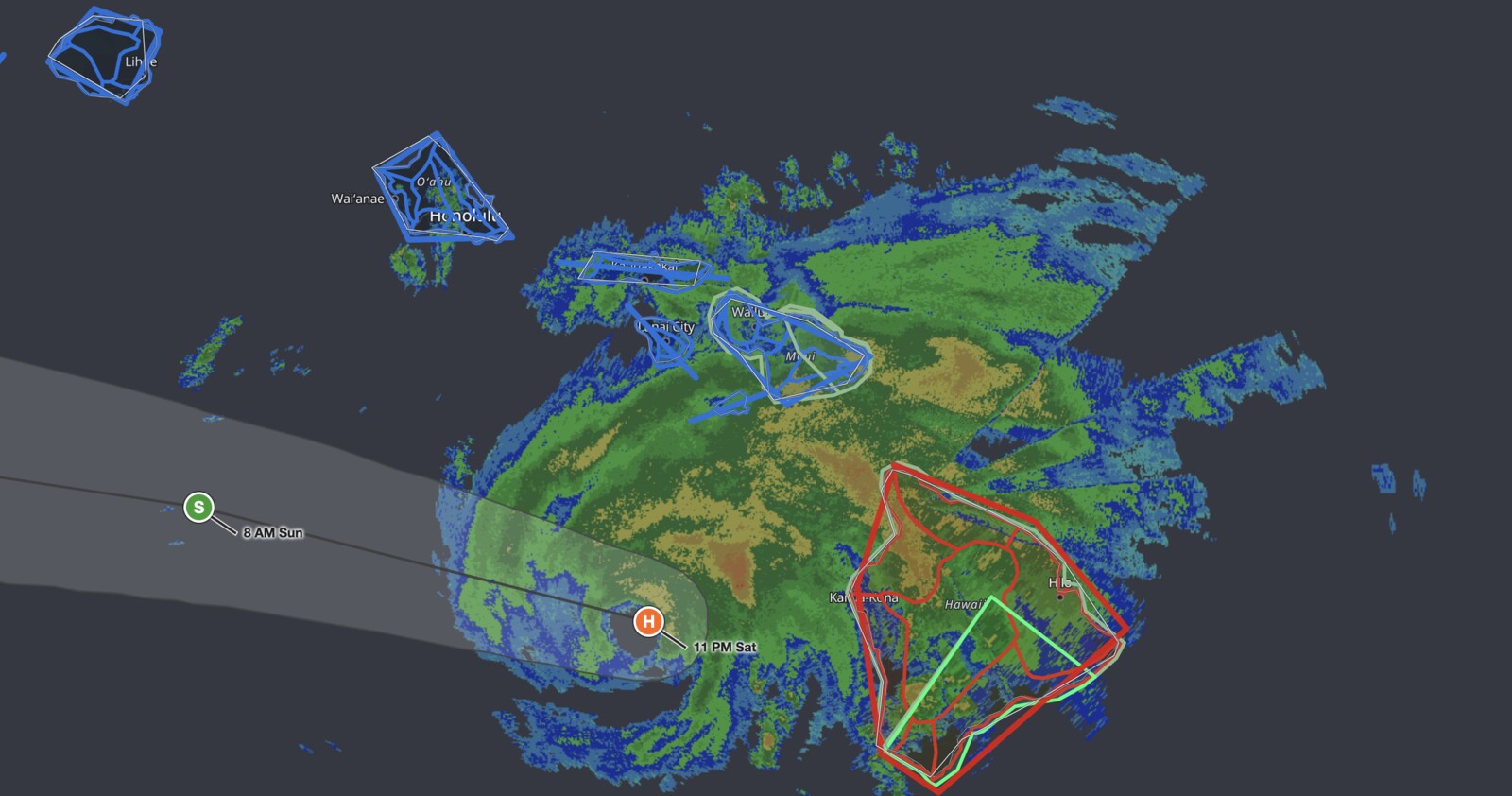
Hawaii Hurricane Lala passed the Big Island offshore overnight and is now weakening as it pulls away to the west, but the flooding threat it left behind is still the dangerous part. The storm held 75 mph maximum sustained winds at 8:00 PM HST Saturday, August 15, 2026, with the center about 55 miles west of South Point, according to the National Hurricane Center’s Intermediate Advisory Number 15A. iAlert’s radar and warning analysis at 11:00 PM HST placed the center still offshore southwest of the Big Island, with the official track carrying Lala back below hurricane strength by 8:00 AM Sunday as damaging winds and heavy rain spread west toward Oahu and Kauai County.
Key points:
- Hurricane Warning in effect for Hawaii County; Tropical Storm Warnings cover Maui, Oahu, and Kauai County.
- Maximum sustained winds near 75 mph at the 8:00 PM advisory, with the forecast track dropping Lala back to tropical storm strength by Sunday morning.
- Rainfall of 10 to 20 inches forecast for the Big Island, with isolated totals up to 25 inches possible.
- Life-threatening flooding, mudslides, and dangerous surf and rip currents expected across the island chain.
- Storm surge of 1 to 3 feet above ground possible along Hawaii County coastlines.
- Hawaii Hurricane Lala tracked offshore and is not forecast to make landfall on any Hawaiian island.
Get Severe Weather Alerts for Your Location
When any NWS watch, warning, or advisory is issued for your area, iAlert sends you an immediate notification by email, text message, or phone call, 24 hours a day, 7 days a week.
Sign Up for Severe Weather Alerts →Hawaii Hurricane Lala: Warnings, Location, and Track
At 8:00 PM HST Saturday, the NHC placed the center of Hawaii Hurricane Lala at approximately 19.1°N, 156.5°W, moving northwest at 10 mph. That position is consistent with the 55-mile figure in the advisory, and the storm’s average motion since the 5:00 AM bulletin works out to roughly 10 mph toward the west-northwest. A gradual westward turn with an increase in forward speed was forecast for Sunday, with the core of the storm expected to remain south of the smaller main Hawaiian Islands and the easternmost Northwestern Hawaiian Islands through the early part of next week.
Hurricane-force winds were extending outward up to 45 miles from the center, and tropical-storm-force winds were reaching out to 175 miles. Earlier Saturday morning, at 5:00 AM HST, NHC Advisory Number 13 had placed Lala about 110 miles southeast of South Point as a tropical storm with 65 mph winds, noting erratic short-term motion as the circulation interacted with the island and that some strengthening was possible before and during passage near the Big Island. By the 8:00 PM advisory, that strengthening had occurred, with Hawaii Hurricane Lala confirmed as a hurricane.
A Hurricane Warning remains in effect for Hawaii County. Tropical Storm Warnings cover Maui County, including the islands of Maui, Lanai, Molokai, and Kahoolawe; Oahu; and Kauai County, including the islands of Kauai and Niihau. The NHC noted that preparations to protect life and property on the Big Island should already be complete.
One point matters for how the rest of Sunday plays out: the center never came ashore. At 11:00 PM HST the circulation was still over open water southwest of the Big Island, and the forecast track keeps it offshore as it accelerates west. Hawaii Hurricane Lala delivered hurricane conditions to parts of Hawaii County without a landfall. That distinction matters for what comes next: the strongest winds stayed over water, but the rainfall totals do not care whether the center crossed the coast.
Rainfall, Flooding, Storm Surge, and Surf Hazards from Hawaii Hurricane Lala
The NHC forecast 10 to 20 inches of rainfall across the Big Island, with isolated maximum totals up to 25 inches possible. Windward Maui could see an additional 8 to 12 inches, with 4 to 6 inches and maximum amounts up to 8 inches forecast for the rest of the island chain. The NHC stated this rainfall will produce life-threatening flooding and mudslides, especially in areas of steep terrain.
Earlier Saturday morning, NWS Honolulu issued a Flash Flood Warning for the island of Hawaii in Hawaii County, with Doppler radar indicating heavy rain bands from Hawaii Hurricane Lala moving onshore across windward and southeast portions of the Big Island. Rain was falling at a rate of 1 to 2.5 inches per hour, with additional heavy bands anticipated over the Kau and Puna Districts. That warning was still plotted over the southeast Big Island on the 11:00 PM HST iAlert analysis above, well after the center had moved past.
Along the coast, storm surge of 1 to 3 feet above ground is possible for Hawaii County, with the deepest inundation expected along the immediate shoreline, where surge will be accompanied by large and dangerous waves. Swells generated by Hawaii Hurricane Lala are building westward across exposed windward and southern shores and are likely to cause life-threatening surf and rip current conditions.
Meteorologist’s Take
The interaction between Hawaii Hurricane Lala and the Big Island’s terrain is a textbook case of orographic amplification, meaning rainfall is intensified when air is forced up a mountainside. The NHC advisories explicitly noted that wind speeds atop mountains and on windward and leeward slopes are often up to 30 percent stronger than the near-surface winds in the advisory, and can be even greater in some elevated locations. With peaks like Mauna Kea and Mauna Loa rising above 13,000 feet, the Big Island essentially acts as a wall that forces storm winds and moisture sharply upward, concentrating rainfall on windward slopes.
The erratic short-term motion during the closest approach reflects a well-documented phenomenon: large volcanic islands can temporarily disrupt a tropical cyclone’s low-level circulation, causing wobbles in the track. The forecast westward acceleration on Sunday, with the storm remaining south of the smaller islands, is consistent with the storm clearing the terrain influence of the Big Island and responding more directly to the large-scale flow. Weakening back below hurricane strength by Sunday morning does not end the threat, because the rainfall and surf hazards travel with the circulation regardless of whether the peak wind is 75 mph or 65 mph.
The BBC framed Lala ahead of time as a potential first direct hurricane hit on Hawaii in 34 years, a reference to Hurricane Iniki, which struck Kauai in September 1992. That outcome did not happen. The center tracked offshore, and the hurricane-force wind field never fully covered a populated island. It is worth being precise about that, because “first hurricane strike since Iniki” and “first hurricane to bring hurricane conditions to the state since Iniki” are different claims and only the second one holds up. The Central Pacific still sees far fewer landfalling hurricanes than the Atlantic or Gulf Coast, so preparedness and infrastructure face a steep test whenever a storm of this intensity gets close.
How to Stay Safe During Hawaii Hurricane Lala
If you are on the Big Island, the wind threat from Hawaii Hurricane Lala is easing but the water threat is not. Flooding and debris flows routinely peak hours after a tropical system’s closest approach, once saturated slopes give way and streams crest. Do not drive through flooded roads: the NWS reports that more than half of flood-related drownings involve a vehicle driven into hazardous water. If you live near a stream, drainage channel, or steep slope, move to higher ground without waiting for water to rise.
Residents on Maui, Oahu, and Kauai still have time to prepare as tropical storm conditions from Hawaii Hurricane Lala spread westward through Sunday. Secure loose outdoor items, charge devices, and store enough water and supplies for several days. Stay away from beaches and coastal areas: the NHC has flagged life-threatening surf and rip current conditions across exposed shores. Monitor the latest advisories through your active weather alerts on iAlert and your local NWS forecast office.
Hawaii Hurricane Lala FAQ
Did Hurricane Lala make landfall in Hawaii?
No. The center of Hawaii Hurricane Lala tracked offshore, passing about 55 miles west of South Point at 8:00 PM HST Saturday and remaining over open water as it moved away to the west. Parts of Hawaii County still experienced hurricane conditions, but the storm did not come ashore.
When does Hurricane Lala weaken to a tropical storm?
The official track carries Hawaii Hurricane Lala back below hurricane strength by 8:00 AM HST Sunday, August 16, as it accelerates west and away from the island chain. The NHC noted the possibility of some restrengthening over open water early the following week.
Where is the highest risk from Hurricane Lala right now?
Where is the highest risk from Hurricane Lala right now?
The Big Island of Hawaii remains the highest-risk area from Hawaii Hurricane Lala. It is under a Hurricane Warning, and flash flooding, mudslides, storm surge, and dangerous surf continue there even as the center pulls away and winds ease.
How much rain could Hurricane Lala drop on the Big Island?
The NHC forecast 10 to 20 inches of rainfall for the Big Island, with isolated maximum totals up to 25 inches possible, enough to produce life-threatening flooding and mudslides in steep terrain.
Is Oahu under a hurricane warning?
No. Oahu is under a Tropical Storm Warning, not a Hurricane Warning. Tropical storm conditions are expected on Oahu overnight Saturday and into Sunday.
When will Hurricane Lala affect Kauai?
According to the 8:00 PM HST Saturday NHC advisory, tropical storm conditions from Hawaii Hurricane Lala are expected to reach Kauai County through the day Sunday as the storm moves westward past the island chain.
Sources:
- NOAA NHC: Hurricane Lala Intermediate Advisory Number 15A, 8:00 PM HST August 15, 2026
- NWS Honolulu: Flash Flood Warning for Hawaii County, August 15, 2026
- NOAA NHC: Tropical Storm Lala Advisory Number 13, 5:00 AM HST August 15, 2026
- NOAA Central Pacific Hurricane Center: Central North Pacific Tropical Weather Outlook, August 15, 2026
- NOAA NHC: Eastern North Pacific Tropical Weather Outlook, August 15, 2026
- BBC News: Storm Lala: Hawaii braces for potential first direct hit by a hurricane in 34 years
- PBS NewsHour: Hawaii’s Big Island lashed by rain and wind as Tropical Storm Lala closes in
Get Severe Weather Alerts for Your Location
When any NWS watch, warning, or advisory is issued for your area, iAlert sends you an immediate notification by email, text message, or phone call, 24 hours a day, 7 days a week.
Sign Up for Severe Weather Alerts →

