
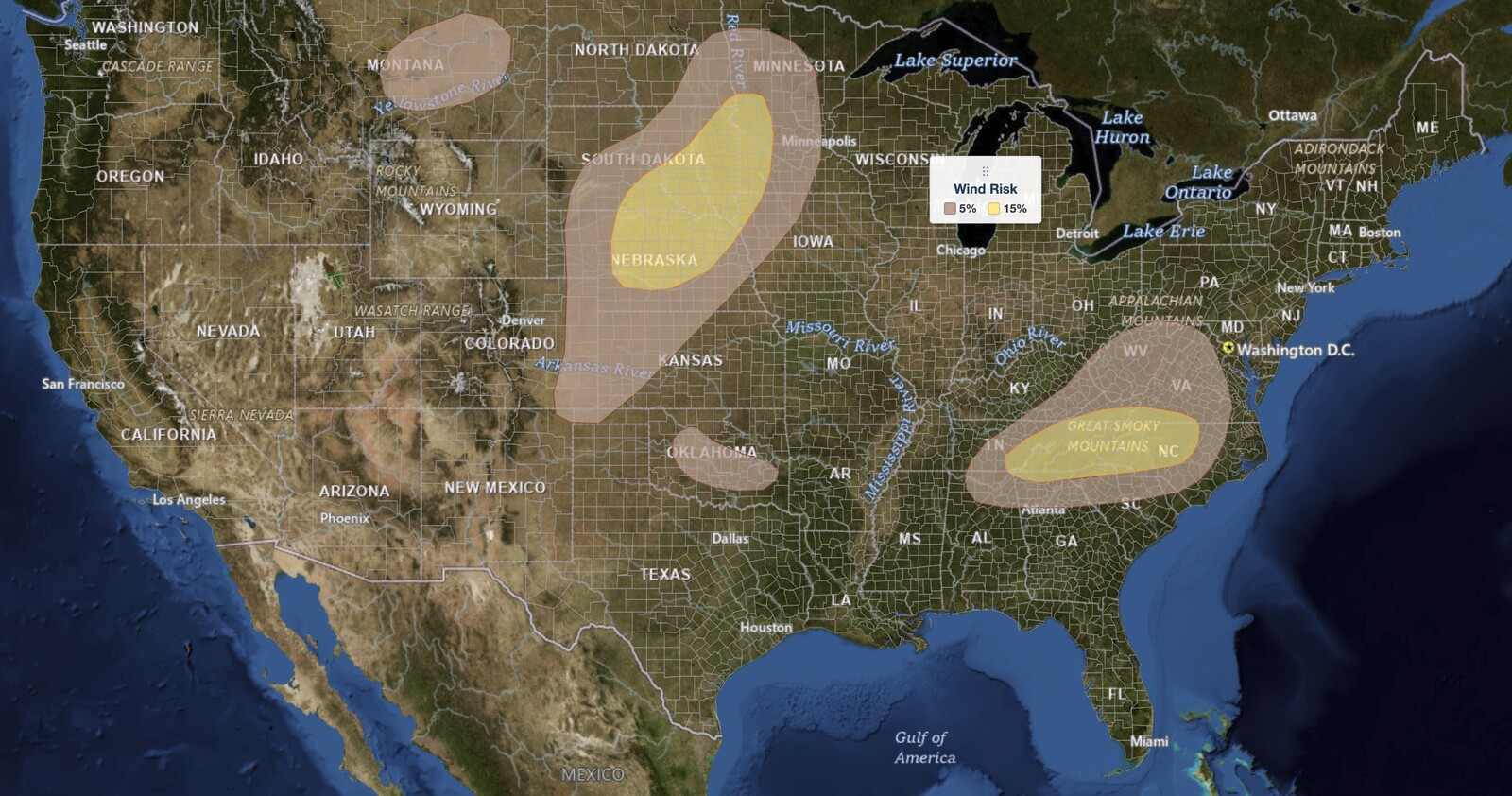
Plains severe thunderstorms are forecast to bring large hail and damaging wind gusts to parts of Nebraska and South Dakota this afternoon and evening, August 17, 2026, according to the NOAA Storm Prediction Center’s Day 1 Convective Outlook issued at 06:02 UTC. A Slight Risk (level 2 of 5) covers two separate areas: one running from central Nebraska northeast into eastern South Dakota, and a second across the Southern Appalachians from eastern Tennessee into central North Carolina.
Key points:
- Two separate Slight Risk (2 of 5) areas are drawn: the Plains severe thunderstorms corridor in central Nebraska and eastern South Dakota, plus the Southern Appalachians.
- Large hail probability reaches 15% only in the Plains area, near North Platte, Norfolk, Sioux Falls, Mitchell, Huron, and Watertown.
- Damaging wind probability reaches 15% in both Slight Risk areas, including Charlotte, Asheville, Knoxville, and Chattanooga.
- A 2% tornado probability is drawn over North Platte, Norfolk, Valentine, Sioux Falls, Mitchell, Huron, Yankton, and Brookings.
- Isolated severe gusts are also possible in southern and western Oklahoma and across central Montana.
Get Lightning Detection Alerts for Your Location
When dangerous lightning is detected near your area, iAlert sends you an immediate notification by email or text message so you know when to seek shelter and when it is safe to head back outside.
Sign Up for Lightning Detection Alerts →Where Plains Severe Thunderstorms Pose the Greatest Threat
The SPC places the core of the Plains severe thunderstorms threat in a corridor running from North Platte and Valentine, Nebraska, northeast through Norfolk into Sioux Falls, Mitchell, Huron, Brookings, and Watertown, South Dakota.
North Platte, Norfolk, Valentine, Sioux Falls, Mitchell, Huron, Yankton, and Brookings each carry the full set of hazards: a 15% large hail probability, a 15% damaging wind probability, and a 2% tornado probability. Watertown, South Dakota, carries the 15% hail and 15% wind probabilities but sits outside the tornado outline.
Two cities on the eastern flank of the Plains severe thunderstorms risk area face a narrower threat. Sioux City and Le Mars, Iowa, are inside the Slight Risk and carry the 15% damaging wind probability, but only a 5% hail probability. Their hail threat is meaningfully lower than the corridor to their west.
A separate Slight Risk covers the Southern Appalachians. Asheville, Charlotte, Winston-Salem, Greensboro, Hickory, Boone, Statesville, and Raleigh in North Carolina, along with Knoxville, Chattanooga, Johnson City, and Bristol in Tennessee, and Spartanburg, South Carolina, all carry a 15% damaging wind probability.
Unlike the Plains severe thunderstorms corridor, none of those Southeast cities carry a hail or tornado probability. The SPC drew no hail outline and no tornado outline anywhere east of the Plains in this issuance, so damaging wind is the single hazard across the Appalachian zone.
Greenville, South Carolina, sits roughly 200 feet outside the Slight Risk outline and inside the 15% damaging wind area. Treat Greenville as inside the Slight Risk. The categorical outline and the wind outline are drawn at slightly different resolutions, and a gap that small is a drafting difference rather than a real change in the threat.
A broader Marginal Risk wraps the core Plains severe thunderstorms zone. Omaha, Lincoln, Grand Island, Kearney, Columbus, Fremont, and Chadron, Nebraska; Pierre and Aberdeen, South Dakota; Council Bluffs and Spencer, Iowa; Minneapolis, Mankato, and St. Cloud, Minnesota; and Fargo and Grand Forks, North Dakota all carry a 5% damaging wind probability.
Within that Marginal zone, Lincoln, Grand Island, Kearney, Columbus, Fremont, Chadron, Pierre, Aberdeen, Spencer, and Fargo also carry a 5% large hail probability. Omaha, Council Bluffs, Minneapolis, Mankato, St. Cloud, and Grand Forks sit outside the hail outline and face a wind threat only.
A third Marginal area covers the central Appalachians and mid-Atlantic. Richmond, Roanoke, Charlottesville, Lynchburg, and Blacksburg, Virginia; Charleston and Morgantown, West Virginia; and Huntsville, Alabama each carry a 5% damaging wind probability with no hail or tornado probability attached.
Two smaller Marginal areas round out the outlook. Oklahoma City sits in its own 5% damaging wind area, and a fourth Marginal zone covers central and northeastern Montana, including Lewistown, Roundup, Winnett, and Glasgow, also at 5% damaging wind.
SPC uses a five-tier system to communicate severe weather potential; see the iAlert guide to SPC outlook risk categories for a full breakdown of what each level means.
Meteorologist’s Take on Plains Severe Thunderstorms
A subtle shortwave trough at mid-levels will move across the northern Plains today within west-northwesterly flow. Ahead of it, a broad corridor of low-level moisture is in place, with a moist axis of surface dewpoints in the upper 60s to lower 70s F setting up from northwest Kansas north-northeast into central Nebraska and eastern South Dakota.
Moderate to strong instability will develop along that axis by midday, with MLCAPE climbing into the 2,000 to 3,000 J/kg range. At the surface, a cold front will move southeast across the Dakotas through the day.
Low-level convergence maximizes ahead of that front over central Nebraska and southeast South Dakota, and that is where scattered convective initiation is expected. Storms will then track southeast into stronger instability during the late afternoon and early evening.
RAP forecast soundings valid at 00Z (8:00 pm EDT, 7:00 pm CDT) near the instability axis from northeastern Nebraska into eastern South Dakota show 0-6 km shear near 40 knots, with low to mid-level lapse rates of 7 to 7.5 degrees C per kilometer. That combination supports supercells and isolated large hail where the environment is best.
A mixed storm mode is expected across the Plains severe thunderstorms corridor, though. Both supercells and multicells will be capable of severe wind gusts. The severe threat should continue into the mid evening as a large convective cluster moves southeast into the mid Missouri and upper Mississippi Valleys.
The Southern Appalachians run on a different setup from the Plains severe thunderstorms corridor. A separate mid-level shortwave trough will track east-southeast across the Ohio and Tennessee Valleys today, reaching the southern Appalachians by early evening, with a moist and unstable airmass ahead of it.
Surface dewpoints in the 70s F will build moderate to strong instability there by midday. A cold front advancing southeast into the mountains will combine with topographic forcing to produce scattered afternoon thunderstorm development.
Those storms will move east-southeast across the higher terrain and into the lower elevations by early evening. Deep-layer shear in the Appalachians is weaker than in the Plains, in the 20 to 30 knot range, so the SPC expects severe gusts to come mainly from short organized line segments. Shear in that range rarely sustains the rotating supercells that produce large hail, which fits with the SPC drawing no hail probability across the Southeast.
Across southern and western Oklahoma, a quasi-stationary front will stay in place. Post-frontal surface dewpoints from the mid 60s to mid 70s F, moderate to strong instability, and 0-3 km lapse rates exceeding 8 degrees C per kilometer favor isolated severe wet downbursts.
Over the northern High Plains, west-northwest mid-level flow will ride over a post-frontal airmass, with surface dewpoints near 50 F across central and eastern Montana. MLCAPE only reaches the 500 to 1,000 J/kg range, but very steep low to mid-level lapse rates could support isolated severe wind gusts from storms forming over the higher terrain of central Montana and drifting east across the upper Missouri Valley late in the day.
How to Stay Safe During Plains Severe Thunderstorms
If you are in or near the Plains severe thunderstorms risk area, prepare for large hail and damaging wind gusts, with a tornado possible in the Nebraska and South Dakota corridor. Get vehicles under cover before storms arrive.
The SPC does not forecast a maximum hail size in this issuance. “Large hail” means at least one inch in diameter, roughly quarter size, which is the National Weather Service threshold for a severe thunderstorm.
Secure anything outdoors that a gust could turn into a projectile. If a tornado warning is issued for your county, move to an interior room on the lowest floor of a sturdy building, away from windows, and stay there until the warning expires.
In the Southern Appalachians and across the broader Marginal zones, the hazard is wind. Watch for falling trees and downed power lines after storms pass, and treat every downed line as energized.
Check active weather alerts for your area and enable wireless emergency alerts on your phone before Plains severe thunderstorms develop this afternoon. You can also track storm movement on live radar as the event unfolds.
Plains Severe Thunderstorms FAQ
Where is the highest risk on August 17, 2026?
The highest categorical risk for Plains severe thunderstorms is a Slight Risk (level 2 of 5), covering a corridor from North Platte and Norfolk, Nebraska, through Sioux Falls, Mitchell, and Huron, South Dakota, plus a separate area across the Southern Appalachians that includes Charlotte, Asheville, and Raleigh, NC, and Knoxville and Chattanooga, TN.
How large could hail get in the Plains severe thunderstorms area?
The SPC assigns a 15% large hail probability to North Platte, Norfolk, Valentine, Sioux Falls, Mitchell, Huron, and Watertown, meaning large hail is possible where supercells develop. The SPC does not specify a maximum diameter in this issuance. Large hail begins at one inch, and the 15% probability targets the best-environment corridor.
Is a tornado possible with today’s Plains severe thunderstorms?
Yes. A 2% tornado probability applies to North Platte, Norfolk, and Valentine in Nebraska, and to Sioux Falls, Mitchell, Huron, Yankton, and Brookings in South Dakota. The tornado threat is narrower than the wind and hail threat and is focused on the highest-shear part of the Plains severe thunderstorms risk area.
When will Plains severe thunderstorms develop and how long will they last?
The SPC expects scattered storm initiation during the late afternoon and early evening. The severe threat is forecast to continue into the mid evening as a convective cluster moves southeast into the mid Missouri and upper Mississippi Valleys. In the Appalachians, the threat could persist into the early evening as storms reach the lower elevations.
Sources:
Get Severe Weather Alerts for Your Location
When any NWS watch, warning, or advisory is issued for your area, iAlert sends you an immediate notification by email, text message, or phone call, 24 hours a day, 7 days a week.
Sign Up for Severe Weather Alerts →

