
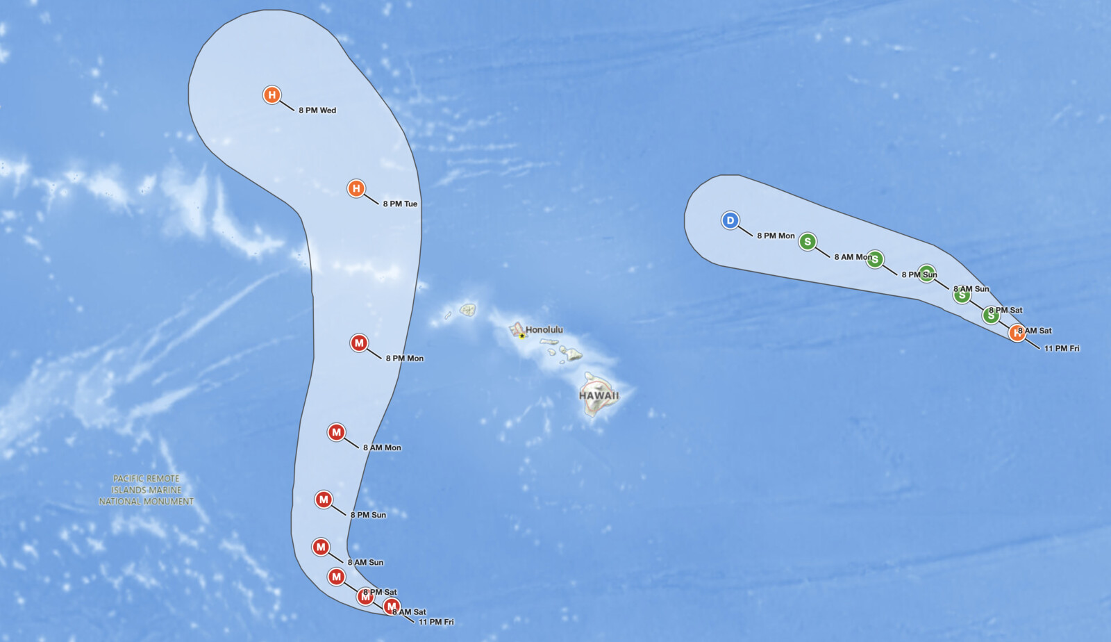
Hawaii Hurricane Lowell peaked at Category 5 strength Friday afternoon, September 4, 2026, then eased to a Category 4 hurricane with 155 mph sustained winds by 11 PM HST as it moved west about 610 miles south-southwest of Honolulu. The National Hurricane Center, which is issuing the Central Pacific Hurricane Center advisories on Lowell, expects a sharp turn to the north on Sunday that would carry the hurricane close to the westernmost main Hawaiian Islands Monday and Monday night. Forecasters say watches will likely be issued Saturday, with Kauai County facing the greatest risk of wind and storm surge impacts.
Key points:
- Hawaii Hurricane Lowell held 155 mph sustained winds and a 925 mb central pressure at 11 PM HST Friday, down slightly from its 160 mph Category 5 peak at 5 PM.
- The center was about 610 miles south-southwest of Honolulu and 625 miles south-southwest of Lihue, moving west at 7 mph.
- A sharp turn to the north or north-northeast is forecast Sunday, bringing Lowell close to the westernmost main islands Monday and Monday night near major hurricane strength.
- Watches will likely be issued Saturday. The NHC flags a risk of storm surge and wind impacts, particularly for Kauai County.
- Kauai and the Big Island face 3 to 6 inches of rain with isolated totals over 10 inches, beginning Sunday afternoon.
- Life-threatening surf and rip currents are already reaching Hawaiian shores and will increase early next week.
Get Severe Weather Alerts for Your Location
When any NWS watch, warning, or advisory is issued for your area, iAlert sends you an immediate notification by email, text message, or phone call, 24 hours a day, 7 days a week.
Sign Up for Severe Weather Alerts →How Hawaii Hurricane Lowell Reached Category 5 Twice
Lowell first reached Category 5 at 11 AM HST Wednesday, September 2, when the NHC raised its maximum sustained winds to 160 mph with a central pressure of 927 mb. Six hours earlier the storm had been a rapidly intensifying Category 4 with 155 mph winds about 455 miles south-southeast of Hilo. The peak did not hold. By 5 AM HST Thursday the winds had fallen to 140 mph with the center about 450 miles south-southwest of Hilo, and by 5 AM HST Friday Lowell was a Category 3 with 125 mph winds and a 947 mb central pressure.
The rebound was fast. Air Force Hurricane Hunters found 150 mph winds and a 930 mb pressure in an off-schedule 8:30 AM HST Friday advisory. By 5 PM HST Friday a NOAA Hurricane Hunter aircraft measured a 922 mb central pressure, the lowest of the storm to date, as Hawaii Hurricane Lowell regained Category 5 status with 160 mph winds. A 35 mph gain in 12 hours meets the definition of rapid intensification (an increase of at least 35 mph in 24 hours).
The 11 PM HST Friday advisory trimmed the intensity to 155 mph and 925 mb based on Air Force Reserve Hurricane Hunter data. Forecasters noted the eye had become slightly more ragged and cloud tops had warmed in the eastern eyewall. Hurricane-force winds extend up to 60 miles from the center and tropical-storm-force winds up to 160 miles. Lowell was moving west near 7 mph with a gradual slowdown expected before the turn.
Forecast Track: Sharp Turn Toward Kauai County
Hawaii Hurricane Lowell is being steered west by a mid-level ridge to its north. NHC forecasters expect that pattern to break down Sunday as a mid- to upper-level low drops south-southeastward north of the Hawaiian Islands and weakens the ridge. That should force a sharp turn to the north or north-northeast and an acceleration, bringing the hurricane close to the westernmost main Hawaiian Islands Monday and Monday night.
The official forecast places Lowell near 21.1°N, 162.9°W at 8 PM HST Monday with 130 mph winds. By iAlert’s calculation from those NHC coordinates, that point is roughly 235 miles west of Lihue and 185 miles west of Niihau. The forecast cone passes just west of Niihau and Kauai, but the wind field is far larger than the cone: tropical-storm-force winds currently reach 160 miles from the center, so a modest eastward shift in the track would bring tropical-storm conditions to Kauai County.
The NHC is explicit that uncertainty remains in where and how sharply the turn occurs, because it depends on the position and strength of the upper low relative to the hurricane. Gradual weakening should begin Sunday as wind shear increases and dry mid-level air works into the circulation, with faster weakening by Monday. Even so, forecasters expect Lowell to remain a powerful hurricane near major hurricane strength as it approaches the western islands.
Hazards Threatening the Hawaiian Islands
Rainfall is a primary concern across the island chain. The NHC expects Hawaii Hurricane Lowell to produce 3 to 6 inches of rain on Kauai and the Big Island, with isolated maximum totals exceeding 10 inches possible in both locations. Maui should expect 2 to 4 inches, with isolated totals up to 8 inches. The remaining islands could see 1 to 2 inches, with maximum amounts of 4 inches. Heavy rain is expected to begin Sunday afternoon and continue into early next week, and it may produce flash flooding and mudslides, especially in areas of steep terrain.
Surf is an immediate and ongoing threat. Swells from Hawaii Hurricane Lowell are already spreading northward and are likely to cause life-threatening surf and rip current conditions across many of the Hawaiian islands over the next several days, with the largest swells arriving early next week. This hazard applies regardless of where the center makes its closest approach.
Wind and storm surge are the newer concerns. The NHC’s key messages flag a risk of storm surge and wind impacts for portions of Hawaii, particularly Kauai County, early next week. No coastal watches or warnings were in effect as of 11 PM HST Friday, but forecasters expect watches will likely be issued Saturday for portions of the westernmost islands. Residents and visitors should stay current with active weather alerts for Hawaii as the situation evolves.
Context: A Busy Central Pacific Season
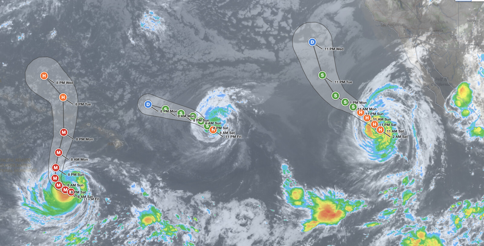
Hawaii Hurricane Lowell is one of three hurricanes under NHC advisories. Hurricane Karina, about 825 miles east of Hilo at 11 PM HST Friday, has weakened to 75 mph and is forecast to become post-tropical by Monday as it turns west-northwest and passes northeast of the islands. On Wednesday morning, Karina had been a 145 mph Category 4 hurricane about 1,455 miles east of Hilo. Hurricane Marie, with 90 mph winds about 635 miles west of the southern tip of the Baja California Peninsula at 2 AM PDT Saturday, is moving northwest and gradually weakening.
The Central Pacific outlook issued at 2 AM HST Saturday calls for no new tropical cyclone formation over the next seven days. The Eastern Pacific outlook gives a 60 percent chance over seven days that an area of low pressure forecast to develop well offshore of southwestern Mexico early next week becomes a tropical depression.
Meteorologist’s Take
Two Category 5 peaks separated by a drop to Category 3 is the signature of a mature hurricane cycling through internal structural changes, most often eyewall replacement cycles (a new outer eyewall forms, chokes off the inner one, and winds dip until the new eyewall contracts). The NHC cites internal structure as the reason further fluctuations are possible over the next day. The 922 mb pressure measured Friday evening, the lowest of the storm to date, shows the core is as deep as it has ever been even if peak winds wobble.
The turn is the entire story for Hawaii, and its timing is sensitive. If the upper low arrives later or weaker than modeled, Lowell continues farther west before turning and the track ends up farther from Kauai. If the low arrives sooner or stronger, the turn comes earlier and closer to the islands. Both outcomes sit inside the current cone, which is why the NHC’s own discussion keeps repeating the uncertainty. Residents should not fixate on the center line. The zone of potential impact is the full cone plus the 160-mile tropical-storm wind radius around it.
The rainfall threat from Hawaii Hurricane Lowell deserves particular attention on Kauai and the Big Island, where steep terrain wrings extra water out of tropical moisture. The forecast acceleration Monday limits how long the core lingers near the islands, which caps the duration of the heaviest rain, but the moisture plume arrives Sunday afternoon well ahead of the center. Flash flooding can develop before the wind ever becomes a factor.
How to Prepare for Hawaii Hurricane Lowell
If you are in Hawaii, and especially Kauai County, now is the time to prepare, not to wait for a watch or warning. Gather enough supplies, including water, food, medications, and phone chargers, to sustain your household for several days. Identify a sturdy interior shelter location in your home in case winds and debris become a threat, and follow the iAlert hurricane tracker for the live NHC cone and forecast points.
Stay off beaches and out of the ocean. Life-threatening surf and rip currents driven by Hawaii Hurricane Lowell are already arriving along Hawaiian shores and will build through the weekend. No swim or surf session is worth the risk while this storm remains active. Monitor your local weather forecast for the latest timing and track updates, and sign up for official alerts so you receive warning the moment watches or warnings are issued for your area.
If local officials issue evacuation orders, follow them promptly. Have a plan for where you will go, how you will get there, and how you will communicate with family members.
Hawaii Hurricane Lowell FAQ
How strong is Hurricane Lowell right now?
As of 11 PM HST Friday, September 4, Hawaii Hurricane Lowell had maximum sustained winds of 155 mph and a central pressure of 925 mb, making it a Category 4 hurricane on the Saffir-Simpson scale. It peaked at 160 mph and 922 mb as a Category 5 at 5 PM HST Friday.
Where is Hurricane Lowell located and where is it headed?
At the 11 PM HST Friday advisory, the center of Hawaii Hurricane Lowell was about 610 miles south-southwest of Honolulu and 625 miles south-southwest of Lihue, moving west near 7 mph. A sharp turn to the north or north-northeast is forecast Sunday, bringing the storm close to the westernmost main Hawaiian Islands Monday and Monday night.
Will Hurricane Lowell hit Hawaii?
The current NHC forecast keeps the center of Hawaii Hurricane Lowell west of Niihau and Kauai, passing roughly 185 to 235 miles offshore Monday night, with no landfall on the main islands. Tropical-storm-force winds extend 160 miles from the center and the track could still shift, so Kauai County faces a real risk of wind, storm surge, and heavy rain impacts. Watches will likely be issued Saturday.
When will watches or warnings be issued for Hawaii?
The NHC stated that watches will likely be issued Saturday, September 5, for portions of the westernmost Hawaiian Islands. No coastal watches or warnings were in effect as of the 11 PM HST Friday advisory.
What rainfall totals are expected for Hawaii?
Kauai and the Big Island face 3 to 6 inches, with isolated totals exceeding 10 inches possible. Maui should expect 2 to 4 inches, with isolated totals up to 8 inches, and other islands could see 1 to 2 inches with up to 4 inches in localized areas. Heavy rain begins Sunday afternoon.
Sources:
- NHC/CPHC Hurricane Lowell Advisory Number 37, 11 PM HST September 4, 2026
- NHC/CPHC Hurricane Lowell Forecast Discussion Number 37 and Key Messages, 11 PM HST September 4, 2026
- NHC/CPHC Hurricane Lowell Advisory Number 36, 5 PM HST September 4, 2026
- NHC/CPHC Hurricane Lowell Advisory Number 33, 5 AM HST September 4, 2026
- NHC/CPHC Hurricane Lowell Advisory Number 29, 5 AM HST September 3, 2026
- NHC/CPHC Hurricane Lowell Advisory Number 26, 11 AM HST September 2, 2026
- NHC/CPHC Hurricane Lowell Advisory Number 25, 5 AM HST September 2, 2026
- NHC Hurricane Lowell Advisory Archive (EP122026)
- NHC/CPHC Hurricane Karina Advisory Number 36, 11 PM HST September 4, 2026
- NHC Hurricane Karina Advisory Number 25, 5 AM HST September 2, 2026
- NHC Hurricane Marie Advisory Number 17, 2 AM PDT September 5, 2026
- NHC Eastern North Pacific Tropical Weather Outlook, 5 AM PDT September 5, 2026
- CPHC Central North Pacific Tropical Weather Outlook, 2 AM HST September 5, 2026
Get Severe Weather Alerts for Your Location
When any NWS watch, warning, or advisory is issued for your area, iAlert sends you an immediate notification by email, text message, or phone call, 24 hours a day, 7 days a week.
Sign Up for Severe Weather Alerts →

