
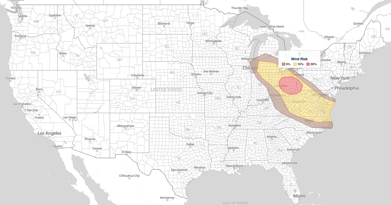
Great Lakes Mid-Atlantic severe thunderstorms are the main weather story on September 4, 2026. The NOAA Storm Prediction Center’s Day 1 Convective Outlook, issued at 12:55 UTC (8:55 am EDT / 7:55 am CDT), places a corridor from southern Michigan and Ohio through Pittsburgh, Charleston, and Washington D.C. to the Virginia and North Carolina coast under a Slight Risk (level 2 of 5). Damaging wind gusts are the primary threat, and the highest probability, 30%, is centered on Columbus, Akron, Canton, and Pittsburgh.
Key points:
- Slight Risk (level 2 of 5) covers the southern Great Lakes into the Mid-Atlantic. The outlook is valid from 13Z (9:00 am EDT / 8:00 am CDT) September 4 through 12Z (8:00 am EDT / 7:00 am CDT) September 5.
- A 30% damaging wind probability, the highest for Great Lakes Mid-Atlantic severe thunderstorms today, covers 20,713 square miles and about 6 million people across central and eastern Ohio into western Pennsylvania, including Columbus, Akron, Canton, and Pittsburgh.
- A 15% damaging wind probability covers 117,491 square miles and 26 million people, including Detroit, Cleveland, Toledo, Charleston, Washington D.C., Richmond, and Norfolk.
- Bowing line segments are the expected storm mode. No tornado probability is drawn anywhere in the outlook.
- Two Marginal Risk bands flank the Slight Risk: one from Flint and Cincinnati to Raleigh, and one from the Lake Erie shore through western Pennsylvania to Baltimore and Annapolis.
Get Severe Weather Alerts for Your Location
When any NWS watch, warning, or advisory is issued for your area, iAlert sends you an immediate notification by email, text message, or phone call, 24 hours a day, 7 days a week.
Sign Up for Severe Weather Alerts →Where Great Lakes Mid-Atlantic Severe Thunderstorms Are Most Likely
The Slight Risk for Great Lakes Mid-Atlantic severe thunderstorms runs from southwest Michigan and northern Indiana across Ohio and West Virginia to the Chesapeake Bay and the North Carolina Outer Banks. Cities inside it include Detroit, Ann Arbor, Lansing, Grand Rapids, Kalamazoo, South Bend, Fort Wayne, Toledo, Cleveland, Akron, Youngstown, Columbus, Lima, Findlay, Pittsburgh, Morgantown, Charleston, Roanoke, Richmond, Norfolk, Virginia Beach, Washington D.C., and Salisbury, Maryland. The Slight Risk outline matches the combined 15% and 30% wind polygons to within 0.2% of its area, so the wind threat alone earned the category.
The core of the threat from Great Lakes Mid-Atlantic severe thunderstorms is a 30% damaging wind probability over central and eastern Ohio into western Pennsylvania and the northern West Virginia panhandle. The SPC puts that area at 20,713 square miles and 5,988,149 people and names Columbus, Pittsburgh, Akron, Canton, and Cuyahoga Falls inside it. Point-in-polygon checks against the frozen outlook also place Mansfield, Marion, Wooster, Newark, Zanesville, Cambridge, Steubenville, Wheeling, and Parkersburg in the 30% area. Youngstown sits about 3 miles outside the 30% line and Cleveland about 17 miles outside, so both carry the 15% probability.
The broader 15% damaging wind probability covers 117,491 square miles and 25,967,296 people. The SPC names Detroit, Washington D.C., Cleveland, Virginia Beach, and Toledo, and the polygon also takes in Fort Wayne, Grand Rapids, Lansing, Kalamazoo, Ann Arbor, South Bend, Lima, Findlay, Charleston, Huntington, Beckley, Roanoke, Lynchburg, Richmond, Fredericksburg, Norfolk, and Salisbury. Every Slight Risk city carries at least a 15% wind probability from Great Lakes Mid-Atlantic severe thunderstorms.
Large hail is a secondary hazard with Great Lakes Mid-Atlantic severe thunderstorms. A 5% large hail probability covers 137,103 square miles and 31,906,068 people, nearly the whole Slight Risk, with the SPC naming Detroit, Columbus, Washington D.C., Cleveland, and Virginia Beach. A few Slight Risk cities on the polygon’s edge carry no hail probability: Grand Rapids (less than a mile outside the hail line), Pontiac, Michigan, Salisbury and Ocean City, Maryland, and Kitty Hawk, North Carolina. For those cities, damaging wind is the only outlined hazard.
Two separate Marginal Risk bands, the first of five SPC severe categories, wrap the Slight Risk for Great Lakes Mid-Atlantic severe thunderstorms, and each traces a 5% damaging wind line. The western and southern band arcs from Muskegon, Saginaw, and Flint in Michigan through Dayton and Cincinnati, southern Ohio, eastern Kentucky, and southwest Virginia to Winston-Salem, Greensboro, Durham, Raleigh, Rocky Mount, and Greenville, North Carolina, ending on the Outer Banks near Cape Hatteras. No hail probability is drawn in that band.
The northeastern band runs from Ashtabula and Painesville on the Lake Erie shore through Sharon, Butler, Kittanning, Indiana, Johnstown, Altoona, Bedford, and Chambersburg, Pennsylvania, to Hagerstown, Frederick, Westminster, Baltimore, Columbia, Annapolis, and Easton, Maryland. Hagerstown, Frederick, Johnstown, and Sharon also sit inside the 5% hail probability, which spills over the Slight Risk line there. The SPC puts the total 5% wind area at 67,685 square miles and 13,449,219 people, naming Baltimore, Raleigh, Cincinnati, Greensboro, and Durham.
Cities in a General Thunderstorms area with no severe probability include Erie, State College, Harrisburg, York, Lancaster, Philadelphia, Wilmington, Delaware, Lexington, Louisville, Indianapolis, Chicago, Milwaukee, and Charlotte. Buffalo, Rochester, Syracuse, Binghamton, Scranton, Allentown, and New York City are outside any thunderstorm area for this outlook period.
Meteorologist’s Take on Great Lakes Mid-Atlantic Severe Thunderstorms
The setup for Great Lakes Mid-Atlantic severe thunderstorms begins with a deep cyclone over the Pacific Northwest and upper-level ridging across most of the country east of the Rockies. A belt of enhanced mid-level flow arcs between those two features from southern California through the central Rockies and northern Plains into the Upper Midwest and eventually the Northeast. South and east of that belt, a reservoir of low-level moisture sits beneath the ridge. A weak front runs from southern New England through southern New York, central Lower Michigan, and central Wisconsin to a weak low over southern Minnesota.
A large cluster of showers and thunderstorms, initiated by warm-air advection across Minnesota and Wisconsin, was already in progress early this morning from southern Wisconsin into southern Lower Michigan. The SPC expects that cluster to continue southeastward today into an airmass destabilized by daytime heating. Steeper mid-level lapse rates stay displaced west of the region, but dewpoints in the upper 60s to low 70s and afternoon temperatures from the mid 80s to mid 90s will still support moderate to strong instability for Great Lakes Mid-Atlantic severe thunderstorms.
Reintensification of the ongoing cluster or new development is expected as it tracks southeast. Most of the region sits on the southern fringe of the stronger deep-layer shear, so bowing line segments are the predominant storm mode in the forecast. The best overlap of instability and shear is expected across central and eastern Ohio, which is why the 30% wind corridor is drawn there. The SPC summary describes a couple of organized clusters across the southern Great Lakes and the mid and upper Ohio Valley today through tonight.
In the Mid-Atlantic, the damaging gust threat arrives this afternoon and evening in a very warm and moist airmass. Vertical wind shear is weak
In the Mid-Atlantic, the damaging gust threat arrives this afternoon and evening in a very warm and moist airmass. Vertical wind shear is weak there, but precipitable water values of 1.8 to 2 inches, strong instability, and steep low-level lapse rates support strong outflow capable of wind damage. Bowing line segments are again the expected mode. The SPC gives no clock times beyond “this afternoon and evening” for the Mid-Atlantic, and it describes the storms east of the Blue Ridge as more widely scattered than the Ohio Valley clusters.
A separate, lower-confidence storm area exists across the Central Plains, where weak lee troughing could focus low-level convergence from western Kansas across western and central Nebraska into southwest South Dakota. Warm mid-levels, leftover convective inhibition, and large-scale height rises cast doubt on whether storms initiate at all, so the SPC drew no severe probabilities there.
How to Stay Safe During Great Lakes Mid-Atlantic Severe Thunderstorms
Damaging wind is the lead hazard in Great Lakes Mid-Atlantic severe thunderstorms today. Damaging wind means a gust of 58 mph or greater, the National Weather Service severe threshold. Large hail, at least one inch in diameter, is possible across most of the Slight Risk as well. Move indoors and away from windows when storms approach, and secure or bring inside outdoor furniture and anything else strong wind can lift. Keep a close watch on active weather alerts so you know the moment a Severe Thunderstorm Warning is issued for your county.
If you are driving when a storm moves through, pull off the road and park away from trees and utility poles. Fallen trees and downed power lines are the most common sources of injury in wind damage events like the ones expected with Great Lakes Mid-Atlantic severe thunderstorms.
The storm clusters are expected to track through the region from this morning into tonight, so stay weather-aware through the evening, especially in the Mid-Atlantic where the arrival is later. SPC uses a five-tier system to communicate severe weather potential; see the iAlert guide to SPC outlook risk categories for a full explanation. You can also check your local weather forecast for the latest storm timing in your area.
Great Lakes Mid-Atlantic Severe Thunderstorms FAQ
Where is the highest risk for damaging wind today?
The 30% damaging wind probability over central and eastern Ohio into western Pennsylvania is the highest for Great Lakes Mid-Atlantic severe thunderstorms today. It covers Columbus, Akron, Canton, Cuyahoga Falls, Pittsburgh, Mansfield, Zanesville, Steubenville, Wheeling, and Parkersburg, and it means a 30% chance of a damaging wind report within 25 miles of any point in that area. The SPC ties it to the best overlap of instability and deep-layer shear across central and eastern Ohio.
How large could hail get in Great Lakes Mid-Atlantic severe thunderstorms?
The SPC draws a 5% large hail probability across nearly the whole Slight Risk and into the northeastern Marginal band, but the discussion does not name a hail size for this event. The National Weather Service definition of large hail is at least one inch in diameter. The discussion focuses on damaging wind, and the hail probability is the lowest tier the SPC draws.
Are tornadoes expected with Great Lakes Mid-Atlantic severe thunderstorms today?
No. The SPC drew no tornado probability anywhere in this outlook, and the tornado risk table reads “No Risk Areas Forecast.” The discussion describes bowing line segments as the storm mode, with the Great Lakes region on the southern fringe of the stronger shear and vertical shear weak across the Mid-Atlantic.
When will storms arrive in the Mid-Atlantic?
The SPC says the damaging gust threat extends into the Mid-Atlantic, including Washington D.C., Richmond, and Norfolk, this afternoon and evening. It does not give a specific arrival hour. The outlook is valid from 9:00 am EDT September 4 through 8:00 am EDT September 5, and the Ohio Valley clusters are expected today through tonight, so Great Lakes Mid-Atlantic severe thunderstorms can continue after dark.
Sources:
Get Severe Weather Alerts for Your Location
When any NWS watch, warning, or advisory is issued for your area, iAlert sends you an immediate notification by email, text message, or phone call, 24 hours a day, 7 days a week.
Sign Up for Severe Weather Alerts →

