
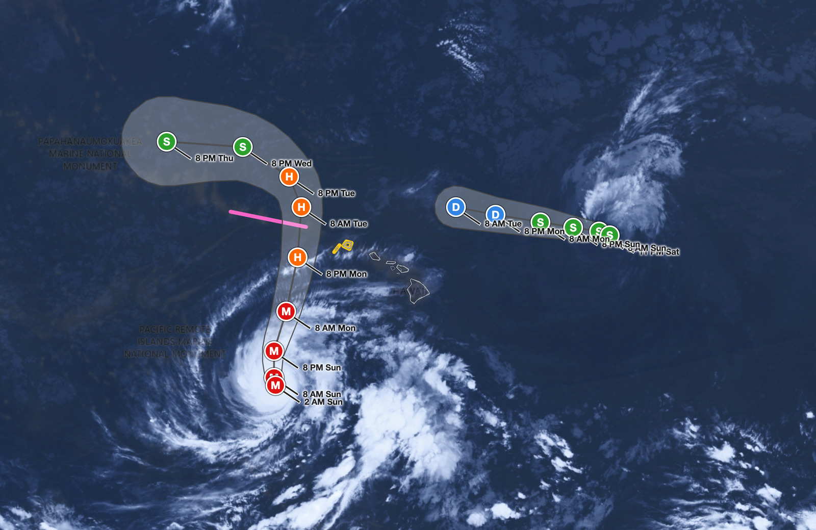
Hawaii Hurricane Lowell is a dangerous Category 3 storm with maximum sustained winds of 125 mph as of 2:00 AM HST Sunday, September 6, 2026, located about 595 miles south-southwest of Lihue. A Tropical Storm Watch is in effect for Kauai County, including Kauai and Niihau, while a Hurricane Watch covers the Papahanaumokuakea Marine National Monument from Nihoa to French Frigate Shoals, with tropical storm conditions possible on Kauai by late Monday or Monday night.
Key points:
- Hawaii Hurricane Lowell carries 125 mph sustained winds as a Category 3 storm with a 943 mb central pressure.
- Tropical Storm Watch issued for Kauai County; Hurricane Watch for Papahanaumokuakea from Nihoa to French Frigate Shoals.
- Storm center expected to move across Papahanaumokuakea just west of the main islands Monday night.
- Kauai faces up to 12+ inches of rain; significant flash flooding and mudslides are possible on Kauai and parts of the Big Island.
- Life-threatening surf and rip currents possible across many Hawaiian islands in coming days.
Get Severe Weather Alerts for Your Location
When any NWS watch, warning, or advisory is issued for your area, iAlert sends you an immediate notification by email, text message, or phone call, 24 hours a day, 7 days a week.
Sign Up for Severe Weather Alerts →Hawaii Hurricane Lowell Track and Timing
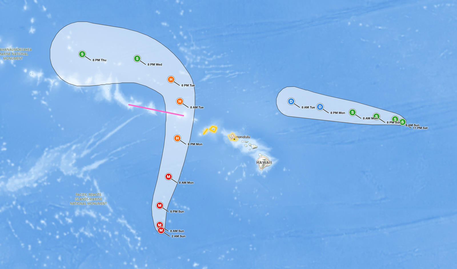
Hawaii Hurricane Lowell was moving north-northwest at about 6 mph at the time of the 2:00 AM advisory. The National Hurricane Center expects a turn toward the north later Sunday, followed by a north-northeastward motion with increasing forward speed Sunday night and Monday. On that forecast track, the center of Hawaii Hurricane Lowell will move across portions of the Papahanaumokuakea Marine National Monument, just west of the main Hawaiian Islands, Monday night.
Air Force Reserve Hurricane Hunters confirmed the storm’s intensity during their overnight reconnaissance mission. Hurricane-force winds currently extend outward up to 45 miles from the center, while tropical-storm-force winds reach up to 175 miles. The minimum central pressure stands at 943 mb based on aircraft dropsonde data, consistent with a strong Category 3 system.
The NHC notes that some fluctuations in intensity remain possible through Sunday morning, followed by gradual weakening later Sunday and Monday. Even with weakening, residents across Kauai County and interests throughout the rest of the Hawaiian Islands should closely monitor advisories, as warnings are likely to be issued later Sunday, according to the NHC advisory. The next complete advisory is scheduled for 5:00 AM HST Sunday.
A second system, Tropical Storm Karina, was about 715 miles east-northeast of Hilo with 60 mph winds at 11:00 PM HST Saturday. Karina poses no threat to land and is forecast to become a post-tropical low within the next day or two as it passes northeast of the islands.
Rainfall, Surge, and Surf Hazards from Hawaii Hurricane Lowell
The rainfall threat from Hawaii Hurricane Lowell is substantial, especially for Kauai. The NHC projects 4 to 8 inches island-wide, with isolated maximum totals exceeding 12 inches. This level of rainfall can trigger significant flash flooding and mudslides, especially on Kauai and portions of the Big Island. The Big Island can expect 2 to 6 inches with isolated totals up to 10 inches, and Maui faces 2 to 4 inches with isolated maximums up to 8 inches. The remaining islands could see 2 to 4 inches.
Storm surge is an additional concern for coastal areas. In Kauai County, rising water could reach 1 to 3 feet above ground in vulnerable low-lying coastal zones if the peak surge coincides with high tide. Oahu could see up to 1 foot of surge-related flooding. The deepest surge water is expected along the immediate coast near and to the right of the storm’s center, compounded by large and destructive waves. Swells from Hawaii Hurricane Lowell are also likely to produce life-threatening surf and rip current conditions across many Hawaiian islands over the next several days.
Meteorologist’s Take
A 943 mb central pressure is a hallmark of a well-organized, mature tropical cyclone. At that pressure, Category 3 intensity is physically consistent, and the storm retains a substantial wind field even if the peak intensity fluctuates slightly in the short term. The 175-mile radius of tropical-storm-force winds means hazardous conditions can extend well beyond the core, affecting islands that are not directly in the storm’s path.
The track geometry here is critical. A storm passing just west of the main Hawaiian Islands, rather than making a direct landfall, still poses serious wind, surge, and rainfall threats to the northwestern end of the island chain, especially Kauai. Orographic enhancement, where moist air is forced upward over mountainous terrain, can concentrate rainfall totals far above the island-wide averages the NHC projects, making flash flooding a primary life-safety concern even though the center is forecast to stay offshore.
You can track the latest watches and warnings as they are updated by monitoring active weather alerts at iAlert, follow the storm on the iAlert hurricane tracker, and check your local weather forecast for conditions specific to your location.
How to Stay Safe During Hawaii Hurricane Lowell
If you are in Kauai County or elsewhere in the Hawaiian Islands, now is the time to act before conditions deteriorate. Residents in coastal or flood-prone areas should follow any evacuation orders issued by local officials without delay. Move to higher ground well ahead of anticipated surge or flood conditions, as flash flooding from 12-inch rainfall totals can develop with little warning on steep island terrain.
Secure loose outdoor items that could become projectiles in tropical storm force winds. Charge devices, gather medications, and assemble a go-bag in case you need to shelter at a designated emergency facility. Avoid streams, drainage channels, and coastal areas during and immediately after the storm, as floodwaters can rise rapidly and rip currents will remain dangerous for several days. Monitor advisories from the National Hurricane Center and your local National Weather Service office frequently, as warnings and watch upgrades are expected later Sunday.
Hawaii Hurricane Lowell FAQ
Where is Hawaii Hurricane Lowell right now?
As of 2:00 AM HST Sunday, September 6, 2026, Hawaii Hurricane Lowell was located about 595 miles south-southwest of Lihue and about 610 miles southwest of Honolulu, moving north-northwest at 6 mph.
What watch or warning is in effect for Kauai?
A Tropical Storm Watch is in effect for Kauai County, including the islands of Kauai and Niihau. This means tropical storm conditions are possible there, generally within 48 hours.
Is Oahu or Honolulu under a watch for Hawaii Hurricane Lowell?
No tropical storm or hurricane watch was in effect for Oahu as of the 2:00 AM HST advisory. The NHC lists up to 1 foot of storm surge for Oahu and says interests elsewhere in the Hawaiian Islands should monitor the storm, with warnings likely later Sunday.
How much rain could Kauai receive from Hawaii Hurricane Lowell?
The NHC projects 4 to 8 inches of rainfall for Kauai, with isolated maximum totals exceeding 12 inches possible. This level of rainfall may produce significant flash flooding and mudslides.
Is Hawaii Hurricane Lowell expected to weaken before reaching the islands?
The NHC forecasts gradual weakening later Sunday and Monday. However, Hawaii Hurricane Lowell remains a Category 3 storm, and even a weakening system can bring dangerous wind, surge, and rainfall impacts to Kauai and nearby islands.
Sources:
- National Hurricane Center, Hurricane Lowell Intermediate Advisory Number 41A, 2:00 AM HST September 6, 2026
- National Hurricane Center, Tropical Storm Karina Advisory Number 40, 11:00 PM HST September 5, 2026
Sources:
Get Severe Weather Alerts for Your Location
When any NWS watch, warning, or advisory is issued for your area, iAlert sends you an immediate notification by email, text message, or phone call, 24 hours a day, 7 days a week.
Sign Up for Severe Weather Alerts →

