
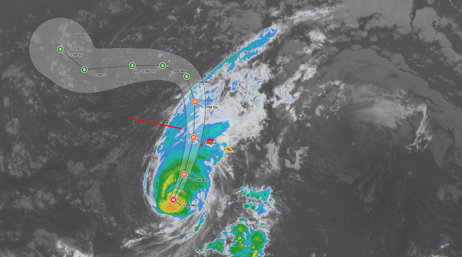
Hawaii Hurricane Lowell is bearing down on the Hawaiian Islands as a Category 3 hurricane with maximum sustained winds of 115 mph, and the National Hurricane Center issued a Tropical Storm Watch for Oahu with its 5:00 AM HST advisory on Monday, September 7, 2026. A Hurricane Warning remains in effect for Kauai County. At 5 AM the center was about 375 miles southwest of Lihue and 405 miles southwest of Honolulu, moving north-northeast at 14 mph. The core of Lowell is forecast to pass near or just west of Niihau tonight and early Tuesday, still at hurricane strength, before turning northwest and slowing by early Wednesday.
Key points:
- Hawaii Hurricane Lowell holds 115 mph sustained winds and a 950 mb central pressure as a Category 3 storm as of 5 AM HST September 7, 2026.
- A Hurricane Warning is in effect for Kauai County, including Kauai and Niihau, and for Papahanaumokuakea from Nihoa to French Frigate Shoals.
- A Tropical Storm Watch is now in effect for Oahu. Any further eastward shift in the forecast would require a Tropical Storm Warning for Oahu.
- Hurricane conditions are expected in Kauai County beginning this afternoon or evening. Tropical storm conditions are possible on Oahu beginning this afternoon.
- Kauai faces an additional 6 to 10 inches of rain with up to 16 inches possible. Significant flash flooding and mudslides are likely on Kauai and parts of the Big Island.
- Storm surge of 2 to 4 feet is possible along the south coast of Kauai and around Niihau, and several tornadoes are possible near Kauai and Niihau this afternoon through tonight.
Get Severe Weather Alerts for Your Location
When any NWS watch, warning, or advisory is issued for your area, iAlert sends you an immediate notification by email, text message, or phone call, 24 hours a day, 7 days a week.
Sign Up for Severe Weather Alerts →Hawaii Hurricane Lowell: Current Track and Watches in Effect
Hawaii Hurricane Lowell remains a Category 3 storm on the Saffir-Simpson Hurricane Wind Scale with a minimum central pressure of 950 mb. Hurricane-force winds extend outward up to 60 miles from the center, and tropical-storm-force winds reach out up to 175 miles. Forecasters at the National Hurricane Center, which is issuing the Central Pacific Hurricane Center advisories on Lowell, describe a well-organized hurricane with a distinct eye and cold cloud tops in the eyewall. An Air Force Hurricane Hunter aircraft is scheduled to fly into the storm later this morning for a better wind estimate.
The Oahu watch follows a track change. The northward turn that forecasters expected has been delayed, and the model guidance shifted about 30 nautical miles east of the previous forecast. The new NHC track follows that trend and brings the hurricane closer to the western Hawaiian Islands. A north-northeastward to northward motion at a faster forward speed is expected through Tuesday, with the core passing near or just west of Niihau tonight and early Tuesday.
Gradual weakening is expected today and Tuesday as Lowell encounters increasing wind shear and cooler water, but the NHC forecast keeps Hawaii Hurricane Lowell at hurricane strength as it passes the islands: 110 mph at 2 PM Monday and 100 mph at 2 AM Tuesday. Rapid weakening is forecast once the storm moves north of the main Hawaiian Islands, with Lowell dropping to a tropical storm by Wednesday and turning west as it merges with an upper-level low a few hundred miles north of the northwestern Hawaiian Islands.
Interests elsewhere in the Hawaiian Islands and the Papahanaumokuakea Marine National Monument should monitor the progress of Hawaii Hurricane Lowell closely. Hurricane conditions are expected in Papahanaumokuakea between Nihoa and French Frigate Shoals tonight, with tropical storm conditions there beginning this afternoon.
Hawaii Hurricane Lowell Hazards: Wind, Rainfall, Storm Surge, and Tornadoes
Wind is the headline hazard for Kauai County. Damaging hurricane conditions are expected to begin in Kauai County tonight and continue through Tuesday morning, with tropical storm conditions arriving later today. Wind speeds atop hills and mountains and on windward and leeward slopes are often up to 30 percent stronger than near-surface winds, a serious concern for residents and visitors in elevated terrain on Kauai. Tropical storm conditions are possible on Oahu beginning this afternoon.
Rainfall from Hawaii Hurricane Lowell will increase in coverage across the islands today and continue through Wednesday. The NHC forecasts additional totals of 6 to 10 inches on Kauai with maximum totals of 16 inches possible. The Big Island can expect 4 to 8 inches with isolated totals of 12 inches, and Oahu and Maui County 4 to 8 inches with isolated totals of 10 inches. This rainfall may produce significant flash flooding and mudslides, especially across Kauai County and portions of the Big Island.
Storm surge along the south coast of Kauai and around Niihau could reach 2 to 4 feet above ground level if the peak surge coincides with high tide, with up to 1 foot on Oahu. The deepest water is expected along the immediate coast near and to the right of the center, where large and tide, with up to 1 foot on Oahu. The deepest water is expected along the immediate coast near and to the right of the center, where large and destructive waves will accompany the surge. Large damaging waves are expected on exposed portions of Kauai County and are likely to produce coastal flooding and inundation of low-lying areas through early Tuesday. Swells from Lowell will also cause life-threatening surf and rip currents across many of the Hawaiian Islands over the next several days.
Tornadoes are possible near Kauai and Niihau this afternoon through tonight, and a few tornadoes are possible across the remainder of the Hawaiian Islands as the outer bands move through.
Meteorologist’s Take
A 30 nautical mile shift sounds small, but it is the whole story this morning. Hawaii Hurricane Lowell has a tropical-storm-force wind field 350 miles across, and its track runs nearly parallel to the island chain. Every eastward nudge trades a near miss for a direct hit. The NHC has already said one more adjustment of the same size would put Oahu under a Tropical Storm Warning, which is why the watch deserves to be treated as a preparation deadline rather than a heads-up.
Kauai adds its own multiplier. The island’s steep volcanic terrain forces moist air upward and wrings out far more rain than the same storm would drop over open ocean, which is how 6 to 10 inches becomes 16. On those slopes, flash flooding and debris flows can develop with very little warning, sometimes before the strongest winds arrive. A weakening hurricane is still a wet one, and the rain threat outlasts the wind threat by a full day.
The tornado threat in the outer rainbands is the hazard most likely to be overlooked. Tropical cyclones spawn tornadoes well away from the core, and with Lowell tracking past populated islands, even a brief tornado in a neighborhood can be dangerous. It is not the headline wind number, but it belongs on the list.
How to Stay Safe During Hawaii Hurricane Lowell
If you are in Kauai County under the Hurricane Warning, the NHC says preparations to protect life and property should be rushed to completion. Move to a sturdy interior room away from windows and doors before winds increase this afternoon. Do not attempt to travel once winds pick up, as debris and flooding will make roads dangerous. Heed all evacuation orders from local emergency management officials immediately.
Flash flooding and mudslides are the hazards most likely to catch residents off guard during Hawaii Hurricane Lowell. Never walk, swim, or drive through floodwaters. Six inches of moving water can knock a person down, and two feet can carry away most vehicles. Stay away from streams, drainage channels, and low-lying coastal areas through Wednesday, and stay off exposed shorelines where damaging waves and surge are expected through early Tuesday.
On Oahu, treat the Tropical Storm Watch as a call to act now. Secure outdoor furniture and loose items, charge devices, stock emergency supplies, and monitor official guidance closely. If a Tropical Storm Warning or Hurricane Warning is issued for Oahu, be prepared to act quickly. Monitor your active weather alerts through iAlert so you receive immediate notification of any change to the watches or warnings affecting your area, and follow the storm on the iAlert hurricane tracker.
Hawaii Hurricane Lowell FAQ
Where is the highest risk from Hawaii Hurricane Lowell?
Kauai County faces the highest risk. Hurricane conditions are expected to begin this afternoon or evening on September 7, 2026, and damaging hurricane conditions continue through Tuesday morning. Kauai and Niihau are under a Hurricane Warning, with storm surge of 2 to 4 feet and rainfall up to 16 inches forecast.
How strong are Hurricane Lowell’s winds?
Maximum sustained winds are 115 mph with higher gusts as of the 5 AM HST advisory on September 7. The NHC forecasts 110 mph at 2 PM Monday and 100 mph at 2 AM Tuesday as the core passes near Niihau. Winds atop hills and mountains can run up to 30 percent stronger.
Are tornadoes expected from Hawaii Hurricane Lowell?
Yes. Tornadoes are possible near Kauai and Niihau this afternoon through tonight. A few tornadoes are also possible across the remainder of the Hawaiian Islands as outer rainbands move through.
When will Hawaii Hurricane Lowell affect Oahu?
Tropical storm conditions are possible on Oahu beginning this afternoon on September 7, 2026. The NHC says any additional eastward shift in the forecast would require a Tropical Storm Warning for Oahu, possibly as soon as later today.
How did Hawaii Hurricane Lowell get here?
Lowell reached Category 5 twice last week before weakening and turning north toward the islands. See the earlier iAlert coverage: Lowell at 155 mph turning toward Kauai and Lowell holding Category 3 as watches were issued.
Sources:
- NWS National Hurricane Center, Hurricane Lowell Advisory Number 46, 5:00 AM HST September 7, 2026
- NWS National Hurricane Center, Hurricane Lowell Forecast Discussion and Key Messages Number 46, 5:00 AM HST September 7, 2026
- NWS National Hurricane Center, Hurricane Lowell advisory archive
Get Severe Weather Alerts for Your Location
When any NWS watch, warning, or advisory is issued for your area, iAlert sends you an immediate notification by email, text message, or phone call, 24 hours a day, 7 days a week.
Sign Up for Severe Weather Alerts →

